地学前缘 ›› 2024, Vol. 31 ›› Issue (3): 245-259.DOI: 10.13745/j.esf.sf.2023.6.8
谷浩1,2( ), 杨泽强1,2, 高猛3(), 唐相伟1, 王东晓1, 刘奎松1,2, 杨树人3, 郭跃闪1, 王云1,2, 王功文3,4,5,*()
收稿日期:2022-11-19
修回日期:2023-06-12
出版日期:2024-05-25
发布日期:2024-05-25
通信作者:
*王功文(1972—),男,教授,博士生导师,主要从事矿产普查与勘探、地球探测与信息技术研究。E-mail: 作者简介:谷浩(1982—),男,高级工程师,主要从事地质矿产勘查与找矿预测研究。E-mail: 879861310@qq.com基金资助:
GU Hao1,2(), YANG Zeqiang1,2, GAO Meng3(), TANG Xiangwei1, WANG Dongxiao1, LIU Kuisong1,2, YANG Shuren3, GUO Yueshan1, WANG Yun1,2, WANG Gongwen3,4,5,*()
Received:2022-11-19
Revised:2023-06-12
Online:2024-05-25
Published:2024-05-25
摘要:
三维建模与成矿预测已成为当前国内外十分流行且较成熟的技术方法。通过研究银洞坡金矿和破山银矿成矿地质特征,对围山城矿集区开展三维可视化模型构建及深部成矿预测。利用82条地质剖面建立了地质体(地层、岩体、矿体)、构造模型,利用1:5万重磁数据和63条电测深数据建立了密度、磁化率、电阻率等地球物理模型,利用52条岩石剖面、614个钻孔、117个探槽、56个浅井及94个平硐数据建立了地球化学模型,实现了地、物、化数据的综合集成。以“三位一体”找矿预测理论为指导,建立了研究区岩浆热液型Au、Ag矿床三维定量预测模型,确定了Au、Ag矿床成矿有利信息变量;采用证据权法提取了预测变量的权重值和相关程度,选择合适的变量进行成矿预测,利用C-V分形确定阈值,圈定了6个找矿靶区,选择新庄预测靶区(A1)进行钻孔验证,发现金矿体6条,充分证明了利用证据权法进行三维成矿预测具有可行性与科学性,圈定的靶区对矿山进行深边部隐伏矿体找矿具有重要的实践意义。
中图分类号:
谷浩, 杨泽强, 高猛, 唐相伟, 王东晓, 刘奎松, 杨树人, 郭跃闪, 王云, 王功文. 河南围山城金银矿集区三维地质建模与成矿预测[J]. 地学前缘, 2024, 31(3): 245-259.
GU Hao, YANG Zeqiang, GAO Meng, TANG Xiangwei, WANG Dongxiao, LIU Kuisong, YANG Shuren, GUO Yueshan, WANG Yun, WANG Gongwen. Three-dimensional geological modeling and mineral prospectivity mapping in the Weishancheng gold-silver district, Henan, China[J]. Earth Science Frontiers, 2024, 31(3): 245-259.

图1 围山城矿集区地质简图 a—矿集区大地构造位置;b—矿集区地质简图。
Fig.1 Geological rough sketch of ore concentration area in Weishancheng. A—the geotectonic location of the ore-concentrated area; B—geological sketch map of ore-concentrated area.

图2 围山城矿集区金、银矿床成矿模式
Fig.2 Metallogenic model of gold and silver deposits in Weishancheng Mining Area
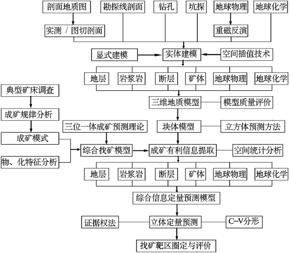
图3 三维地质建模及定量预测技术流程
Fig.3 3D geological modeling and quantitative prediction technology process
| 数据来源 | 磁测总 精度/nT | 野外观测均方误差/nT | 基点、高程及正常场改正误差/nT | |||||||
|---|---|---|---|---|---|---|---|---|---|---|
| 总计 | 操作及 点位差 | 仪器一 致性差 | 仪器噪 声误差 | 日变改 正误差 | 总计 | 正常场 改正差 | 高程改 正误差 | 总基点 改正差 | ||
| 本次测量 | 2.02 | 1.551 | 1.241 | 0.872 | 0.24 | 0.216 | 1.293 | 0.3 | 0.788 | 0.98 |
| DZ/T 0071—1993 | 5 | 4.36 | 2.65 | 2.0 | 2.0 | 2.0 | 2.45 | 1.0 | 1.0 | 2.0 |
表1 磁法实测误差统计结果表
Table 1 Statistical results of errors in magnetic measurement
| 数据来源 | 磁测总 精度/nT | 野外观测均方误差/nT | 基点、高程及正常场改正误差/nT | |||||||
|---|---|---|---|---|---|---|---|---|---|---|
| 总计 | 操作及 点位差 | 仪器一 致性差 | 仪器噪 声误差 | 日变改 正误差 | 总计 | 正常场 改正差 | 高程改 正误差 | 总基点 改正差 | ||
| 本次测量 | 2.02 | 1.551 | 1.241 | 0.872 | 0.24 | 0.216 | 1.293 | 0.3 | 0.788 | 0.98 |
| DZ/T 0071—1993 | 5 | 4.36 | 2.65 | 2.0 | 2.0 | 2.0 | 2.45 | 1.0 | 1.0 | 2.0 |

图4 三维地质模型与矿体关系
Fig.4 Relationship between 3D geological model and orebody

图5 三维地球物理模型
Fig.5 Three-dimensional geophysics model
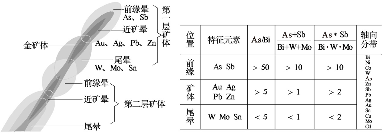
图6 银洞坡金矿床成矿元素垂向与轴向分带特征
Fig.6 Vertical and axial zoning characteristics of ore-forming elements in Yindongpo gold deposit

图7 不同地球化学元素DSI插值模型
Fig.7 DSI interpolation model for different geochemical elements
| 矿床类型 | 控矿因素 | 定量化预测要素 | 矿床实例 | |
|---|---|---|---|---|
| 岩浆热 液型 | 地层 | 歪头山组为赋矿岩层,特别是碳质 绢云石英片岩为主要赋矿围岩 | 二段第一岩性层  | 银洞坡金矿、 破山银矿 |
二段第二岩性层  | ||||
| 三段第二岩性层 | ||||
| 碳质层 | ||||
| 构造 | 朱庄背形构造层间破碎带 | 断裂带 | ||
| 岩浆岩 | 隐伏酸性岩体 | 岩体 | ||
| 地球 物理 | 矿床出现在负重力异常带上 | 低密度 | ||
| 矿床分布在低缓磁异常内 | 低磁化率 | |||
| 矿床显示低电阻率、高激化率 | 低电阻率、高激化率 | |||
| 地球 化学 | 主要元素组合为Au、Ag、Pb、Zn、As、Sb | Au | ||
| Ag | ||||
| Pb | ||||
| Zn | ||||
| As | ||||
| Sb | ||||
表2 综合找矿模型
Table 2 Comprehensive information quantitative prediction model
| 矿床类型 | 控矿因素 | 定量化预测要素 | 矿床实例 | |
|---|---|---|---|---|
| 岩浆热 液型 | 地层 | 歪头山组为赋矿岩层,特别是碳质 绢云石英片岩为主要赋矿围岩 | 二段第一岩性层 | 银洞坡金矿、 破山银矿 |
| 二段第二岩性层 | ||||
| 三段第二岩性层 | ||||
| 碳质层 | ||||
| 构造 | 朱庄背形构造层间破碎带 | 断裂带 | ||
| 岩浆岩 | 隐伏酸性岩体 | 岩体 | ||
| 地球 物理 | 矿床出现在负重力异常带上 | 低密度 | ||
| 矿床分布在低缓磁异常内 | 低磁化率 | |||
| 矿床显示低电阻率、高激化率 | 低电阻率、高激化率 | |||
| 地球 化学 | 主要元素组合为Au、Ag、Pb、Zn、As、Sb | Au | ||
| Ag | ||||
| Pb | ||||
| Zn | ||||
| As | ||||
| Sb | ||||
| 矿种 | 赋矿地层 | 矿体编号 | 矿体规模 | 占比/ % |
|---|---|---|---|---|
| 银多 金属 矿 |  | A7 | 薄层状延伸短 | 2.5 |
| | A8 | 薄层状延伸短 | 2.5 | |
 | A1,A2,A3,A4,A5, A6,A9,A6-2 | 厚层状断续 分布延长远 | 20 | |
 | A10,A10-2 | 薄层状延伸短 | 5 | |
| | A11,A12 | 薄层状延伸短 | 5 | |
| 铅锌矿 |  | A68,A70 | 薄层状延伸短 | 5 |
 | A73,A75 | 薄层状延伸短 | 5 | |
| 金多 金属 矿 |  | 51,51-1 | 薄层状延伸短 | 5 |
| | 52,52-1,52-2,52-3, 53,54,54-1,55,55-1, 56,57,3,3-1,3-2 | 厚层状断续 分布延长远 | 35 | |
 | 1,1-1,1-2,1-3 | 厚层状断续 分布延长远 | 10 | |
 | Au-15 | 薄层状延伸短 | 2.5 | |
| | Au-5 | 薄层状延伸短 | 2.5 |
表3 不同赋矿地层含矿性统计表
Table 3 Statistical table of ore-bearing property of different ore-bearing strata
| 矿种 | 赋矿地层 | 矿体编号 | 矿体规模 | 占比/ % |
|---|---|---|---|---|
| 银多 金属 矿 | | A7 | 薄层状延伸短 | 2.5 |
| | A8 | 薄层状延伸短 | 2.5 | |
| | A1,A2,A3,A4,A5, A6,A9,A6-2 | 厚层状断续 分布延长远 | 20 | |
| | A10,A10-2 | 薄层状延伸短 | 5 | |
| | A11,A12 | 薄层状延伸短 | 5 | |
| 铅锌矿 | | A68,A70 | 薄层状延伸短 | 5 |
| | A73,A75 | 薄层状延伸短 | 5 | |
| 金多 金属 矿 | | 51,51-1 | 薄层状延伸短 | 5 |
| | 52,52-1,52-2,52-3, 53,54,54-1,55,55-1, 56,57,3,3-1,3-2 | 厚层状断续 分布延长远 | 35 | |
| | 1,1-1,1-2,1-3 | 厚层状断续 分布延长远 | 10 | |
| | Au-15 | 薄层状延伸短 | 2.5 | |
| | Au-5 | 薄层状延伸短 | 2.5 |

图8 密度体、低磁体与赋矿地层关系
Fig.8 The relationship between density body, low magnet, and ore-bearing strata
| 信息类型 | 特征变量 | 描述 | 类型 | 值域 | 单元数量 | |
|---|---|---|---|---|---|---|
| 地质 实体 信息 量 |  | 歪头山组上部二岩段 | 二值型 | 0,1 | 39 317 | |
 | 歪头山组中部二岩段 | 二值型 | 0,1 | 120 615 | ||
 | 歪头山组中部一岩段 | 二值型 | 0,1 | 130 777 | ||
| SC | 碳质绢云石英片岩 | 二值型 | 0,1 | 103 537 | ||
| ηγ | 隐伏酸性岩体 | 二值型 | 0,1 | 72 868 | ||
| F | 断裂 | 二值型 | 0,1 | 147 807 | ||
| Au找 矿属 性信 息量 | EH4_ρs | EH4_视电阻率 | 连续型 | 94.751 4,2 724.098 9 | 149 865 | |
| 磁化率 | 磁化率 | 连续型 | 0.004 7,0.011 8 | 418 361 | ||
| 密度 | 密度 | 连续型 | 2.373 7,2.438 9 | 376 736 | ||
| Au | Ag品位插值 | 连续型 | 0.237 7,10.099 6 | 31 946 | ||
| As | As品位插值 | 连续型 | 0.016 1,0.625 8 | 31 652 | ||
| Sb | Sb品位插值 | 连续型 | 0.000 1,0.000 8 | 137 683 | ||
| Ag找 矿属 性信 息量 | EH4_ρs | EH4_视电阻率 | 连续型 | 94.751 4,2 079.913 4 | 594 854 | |
| 磁化率 | 磁化率 | 连续型 | 0.004 7,0.019 2 | 157 569 | ||
| 密度 | 视密度 | 连续型 | 2.413 9,2.489 0 | 487 082 | ||
| Ag | Ag品位插值 | 连续型 | 16.174 9,442.751 3 | 47 590 | ||
| As | As品位插值 | 连续型 | 0.016 1,0.625 8 | 31 652 | ||
| Sb | Sb品位插值 | 连续型 | 0.000 1,0.000 8 | 137 683 | ||
表4 综合信息定量预测模型
Table 4 Comprehensive information quantitative prediction model
| 信息类型 | 特征变量 | 描述 | 类型 | 值域 | 单元数量 | |
|---|---|---|---|---|---|---|
| 地质 实体 信息 量 | | 歪头山组上部二岩段 | 二值型 | 0,1 | 39 317 | |
| | 歪头山组中部二岩段 | 二值型 | 0,1 | 120 615 | ||
| | 歪头山组中部一岩段 | 二值型 | 0,1 | 130 777 | ||
| SC | 碳质绢云石英片岩 | 二值型 | 0,1 | 103 537 | ||
| ηγ | 隐伏酸性岩体 | 二值型 | 0,1 | 72 868 | ||
| F | 断裂 | 二值型 | 0,1 | 147 807 | ||
| Au找 矿属 性信 息量 | EH4_ρs | EH4_视电阻率 | 连续型 | 94.751 4,2 724.098 9 | 149 865 | |
| 磁化率 | 磁化率 | 连续型 | 0.004 7,0.011 8 | 418 361 | ||
| 密度 | 密度 | 连续型 | 2.373 7,2.438 9 | 376 736 | ||
| Au | Ag品位插值 | 连续型 | 0.237 7,10.099 6 | 31 946 | ||
| As | As品位插值 | 连续型 | 0.016 1,0.625 8 | 31 652 | ||
| Sb | Sb品位插值 | 连续型 | 0.000 1,0.000 8 | 137 683 | ||
| Ag找 矿属 性信 息量 | EH4_ρs | EH4_视电阻率 | 连续型 | 94.751 4,2 079.913 4 | 594 854 | |
| 磁化率 | 磁化率 | 连续型 | 0.004 7,0.019 2 | 157 569 | ||
| 密度 | 视密度 | 连续型 | 2.413 9,2.489 0 | 487 082 | ||
| Ag | Ag品位插值 | 连续型 | 16.174 9,442.751 3 | 47 590 | ||
| As | As品位插值 | 连续型 | 0.016 1,0.625 8 | 31 652 | ||
| Sb | Sb品位插值 | 连续型 | 0.000 1,0.000 8 | 137 683 | ||
| 序号 | Layer | W+ | s(W+) | W- | s(W-) | C | s(C) | t-value |
|---|---|---|---|---|---|---|---|---|
| 1 |  | 2.113 1 | 0.013 5 | -0.869 0 | 0.016 6 | 2.982 1 | 0.021 4 | 139.264 8 |
| 2 | EH4_ρs | 1.875 8 | 0.014 0 | -0.748 1 | 0.015 7 | 2.623 9 | 0.021 0 | 124.690 5 |
| 3 | As | 2.669 2 | 0.020 9 | -0.291 2 | 0.012 1 | 2.960 4 | 0.024 1 | 122.697 1 |
| 4 | SC | 1.993 3 | 0.015 5 | -0.557 7 | 0.014 1 | 2.551 0 | 0.021 0 | 121.621 9 |
| 5 | F | 1.774 0 | 0.014 4 | -0.673 4 | 0.015 2 | 2.447 4 | 0.020 9 | 117.109 4 |
| 6 | Sb | 2.412 5 | 0.023 3 | -0.216 8 | 0.011 6 | 2.629 3 | 0.026 0 | 100.935 0 |
| 7 | Au | 2.341 4 | 0.024 0 | -0.199 7 | 0.011 5 | 2.541 1 | 0.026 7 | 95.290 7 |
| 8 | 密度 | 1.099 4 | 0.012 4 | -0.973 3 | 0.019 3 | 2.072 7 | 0.022 9 | 90.606 0 |
| 9 |  | 1.429 5 | 0.017 9 | -0.333 9 | 0.012 8 | 1.763 4 | 0.022 0 | 80.310 0 |
| 10 | 磁化率 | 0.747 3 | 0.014 1 | -0.489 2 | 0.015 3 | 1.236 5 | 0.020 8 | 59.395 0 |
| 11 | | -5.458 9 | 1.000 0 | 0.025 2 | 0.010 4 | -5.484 1 | 1.000 1 | -5.483 7 |
表5 Au证据权法各预测变量权重表
Table 5 Weight table of each predictive variable of Au evidence weight method
| 序号 | Layer | W+ | s(W+) | W- | s(W-) | C | s(C) | t-value |
|---|---|---|---|---|---|---|---|---|
| 1 | | 2.113 1 | 0.013 5 | -0.869 0 | 0.016 6 | 2.982 1 | 0.021 4 | 139.264 8 |
| 2 | EH4_ρs | 1.875 8 | 0.014 0 | -0.748 1 | 0.015 7 | 2.623 9 | 0.021 0 | 124.690 5 |
| 3 | As | 2.669 2 | 0.020 9 | -0.291 2 | 0.012 1 | 2.960 4 | 0.024 1 | 122.697 1 |
| 4 | SC | 1.993 3 | 0.015 5 | -0.557 7 | 0.014 1 | 2.551 0 | 0.021 0 | 121.621 9 |
| 5 | F | 1.774 0 | 0.014 4 | -0.673 4 | 0.015 2 | 2.447 4 | 0.020 9 | 117.109 4 |
| 6 | Sb | 2.412 5 | 0.023 3 | -0.216 8 | 0.011 6 | 2.629 3 | 0.026 0 | 100.935 0 |
| 7 | Au | 2.341 4 | 0.024 0 | -0.199 7 | 0.011 5 | 2.541 1 | 0.026 7 | 95.290 7 |
| 8 | 密度 | 1.099 4 | 0.012 4 | -0.973 3 | 0.019 3 | 2.072 7 | 0.022 9 | 90.606 0 |
| 9 | | 1.429 5 | 0.017 9 | -0.333 9 | 0.012 8 | 1.763 4 | 0.022 0 | 80.310 0 |
| 10 | 磁化率 | 0.747 3 | 0.014 1 | -0.489 2 | 0.015 3 | 1.236 5 | 0.020 8 | 59.395 0 |
| 11 | | -5.458 9 | 1.000 0 | 0.025 2 | 0.010 4 | -5.484 1 | 1.000 1 | -5.483 7 |
| 序号 | Layer | W+ | s(W+) | W- | s(W-) | C | s(C) | t-value |
|---|---|---|---|---|---|---|---|---|
| 1 |  | 2.582 8 | 0.031 6 | -0.362 5 | 0.021 4 | 2.945 3 | 0.038 2 | 77.105 3 |
| 2 | SC | 1.989 7 | 0.025 9 | -0.575 1 | 0.024 4 | 2.564 8 | 0.035 5 | 72.196 7 |
| 3 | Ag | 2.385 9 | 0.031 6 | -0.355 0 | 0.021 4 | 2.740 9 | 0.038 2 | 71.779 8 |
| 4 | Sb | 1.164 8 | 0.021 6 | -0.874 2 | 0.030 8 | 2.039 0 | 0.037 6 | 54.209 4 |
| 5 | 磁化率 | 1.369 3 | 0.028 4 | -0.391 0 | 0.022 6 | 1.760 3 | 0.036 3 | 48.495 5 |
| 6 | 密度 | 0.913 1 | 0.020 2 | -1.100 5 | 0.036 8 | 2.013 7 | 0.042 0 | 47.931 1 |
| 7 | As | 2.114 1 | 0.044 1 | -0.158 2 | 0.019 3 | 2.272 3 | 0.048 2 | 47.186 2 |
| 8 | F | 1.106 3 | 0.033 3 | -0.233 7 | 0.020 9 | 1.340 0 | 0.039 3 | 34.063 9 |
| 9 | EH4_ρs | 1.247 2 | 0.038 9 | -0.171 3 | 0.019 9 | 1.418 5 | 0.043 7 | 32.482 2 |
| 10 |  | -4.495 2 | 0.577 4 | 0.086 6 | 0.017 7 | -4.581 8 | 0.577 6 | -7.932 1 |
| 11 |  | -1.402 8 | 0.128 1 | 0.061 3 | 0.017 9 | -1.464 2 | 0.129 3 | -11.323 0 |
表6 Ag证据权法各预测变量权重表
Table 6 Weight table of each predictive variable of Ag evidence weight method
| 序号 | Layer | W+ | s(W+) | W- | s(W-) | C | s(C) | t-value |
|---|---|---|---|---|---|---|---|---|
| 1 | | 2.582 8 | 0.031 6 | -0.362 5 | 0.021 4 | 2.945 3 | 0.038 2 | 77.105 3 |
| 2 | SC | 1.989 7 | 0.025 9 | -0.575 1 | 0.024 4 | 2.564 8 | 0.035 5 | 72.196 7 |
| 3 | Ag | 2.385 9 | 0.031 6 | -0.355 0 | 0.021 4 | 2.740 9 | 0.038 2 | 71.779 8 |
| 4 | Sb | 1.164 8 | 0.021 6 | -0.874 2 | 0.030 8 | 2.039 0 | 0.037 6 | 54.209 4 |
| 5 | 磁化率 | 1.369 3 | 0.028 4 | -0.391 0 | 0.022 6 | 1.760 3 | 0.036 3 | 48.495 5 |
| 6 | 密度 | 0.913 1 | 0.020 2 | -1.100 5 | 0.036 8 | 2.013 7 | 0.042 0 | 47.931 1 |
| 7 | As | 2.114 1 | 0.044 1 | -0.158 2 | 0.019 3 | 2.272 3 | 0.048 2 | 47.186 2 |
| 8 | F | 1.106 3 | 0.033 3 | -0.233 7 | 0.020 9 | 1.340 0 | 0.039 3 | 34.063 9 |
| 9 | EH4_ρs | 1.247 2 | 0.038 9 | -0.171 3 | 0.019 9 | 1.418 5 | 0.043 7 | 32.482 2 |
| 10 | | -4.495 2 | 0.577 4 | 0.086 6 | 0.017 7 | -4.581 8 | 0.577 6 | -7.932 1 |
| 11 | | -1.402 8 | 0.128 1 | 0.061 3 | 0.017 9 | -1.464 2 | 0.129 3 | -11.323 0 |
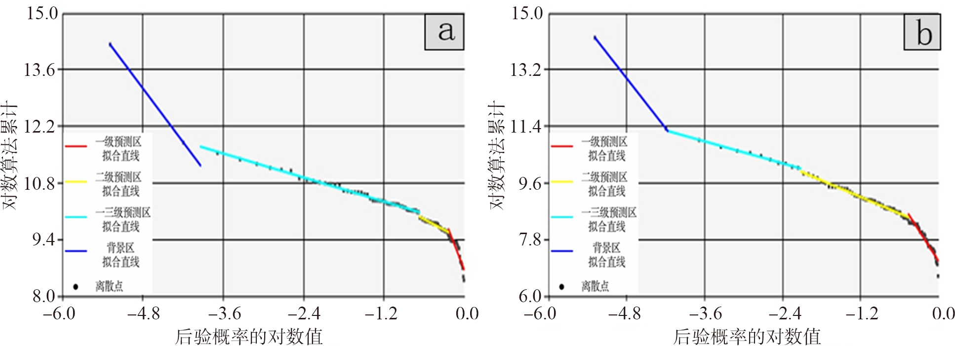
图9 Au、Ag证据权法分形分段拟合直线
Fig.9 Fractal piecewise fitting line of Au, Ag evidence weight method

图10 Au、Ag证据权法预测结果 a—Au预测模型;b—Ag预测模型。
Fig.10 The predicts result of Au, Ag evidence weight method. a—Au prediction model; b—Ag prediction model.

图11 找矿靶区圈定
Fig.11 Delineation of prospecting targets

图12 靶区钻孔验证成果图
Fig.12 Target area drilling verification results map
| [1] | 侯翠霞, 刘向冲, 张文斌, 等. 成矿预测理论与方法新进展[J]. 地质通报, 2010, 29(6): 953-960. |
| [2] | CARLSON E. Three dimensional conceptual modeling of subsurface structures[C]//Proceedings of American congress on surveying and mapping annual convention. Baltimore: American Society for Photogrammetry and Remote Sensing, 1987: 188-200. |
| [3] | SIMON W H. 3D Geoscience modeling: computer techniques for geological characterization[M]. Berlin: Springer-Verlag, 1994. |
| [4] | 赵鹏大. “三联式”资源定量预测与评价: 数字找矿理论与实践探讨[J]. 地球科学: 中国地质大学学报, 2002, 27(5): 482-489. |
| [5] | 赵鹏大, 陈建平, 张寿庭. “三联式”成矿预测新进展[J]. 地学前缘, 2003, 10(2): 455-463. |
| [6] | 王世称, 陈水良, 夏立显. 综合信息矿产预测理论与方法[M]. 北京: 科学出版社, 2002: 1-337. |
| [7] | 陈毓川、 裴荣富, 宋天锐, 等. 中国矿床成矿系列初论[M]. 北京: 地质出版社, 1998: 1-104. |
| [8] | 侯景儒, 黄竟先. 地质统计学的理论与方法[M]. 北京: 地质出版社, 1990: 1-353. |
| [9] | 余先川, 胡丹. 盲源分离理论与应用[M]. 北京: 科学出版社, 2011: 1-336. |
| [10] | 余先川, 俞晨, 侯景儒, 等. 析取克立格理论及其在品位估计中的应用[J]. 北京师范大学学报(自然科学版), 2006, 42(5): 495-497. |
| [11] | 田景文, 高美娟. 人工神经网络算法研究及应用[M]. 北京: 北京理工大学出版社, 2006: 1-283. |
| [12] | 叶天竺, 吕志成, 庞振山, 等. 勘查区找矿预测理论与方法总论[M]. 北京: 地质出版社, 2017: 1-703. |
| [13] | 叶天竺. 矿床模型综合地质信息预测技术方法理论框架[J]. 吉林大学学报(地球科学版), 2013, 43(4): 1053-1072. |
| [14] | 成秋明. 非线性成矿预测理论: 多重分形奇异性-广义自相似性-分形谱系模型与方法[J]. 地球科学: 中国地质大学学报, 2006, 31(3): 337-348. |
| [15] | WANG G W, ZHU Y Y, ZHANG S T, et al. 3D geological modeling based on geological knowledge and gravity and magnetic data inversion in Luanchuan ore region, Henan Province, China[J]. Journal of Applied Geophysics, 2012, 80: 1-11. |
| [16] | WANG G W, ZHU Y Y, ZHANG S T, et al. Application of the multifractal singular value decomposition for delineating geophysical anomalies associated with molybdenum occurrences in the Luanchuan ore field (China)[J]. Journal of Applied Geophysics, 86: 109-119. |
| [17] | 伏雄, 门道改, 李娜, 等. 河南省桐柏围山城金银矿田地质特征及找矿远景分析[J]. 矿产与地质, 2012, 26(3): 198-204. |
| [18] | 张聚. 显式模型预测控制理论与应用[M]. 北京: 电子工业出版社, 2015: 1-256. |
| [19] | MALLET J L. Discrete smooth interpolation in geometric modeling[J]. Computer-aided Design, 1992, 24(4): 178-191. |
| [20] | 孟小红, 侯建全, 梁宏英, 等. 离散光滑插值方法在地球物理位场中的快速实现[J]. 物探与化探, 2002, 26(4): 302-306. |
| [21] | 周军霞, 杨钦, 蔡强. 离散光滑插值方法在多值曲面中的应用[J]. 微计算机信息(管控一体化), 2008, 24(30): 191-192, 174. |
| [22] | OLDENBURG D W. The inversion and interpretation of gravity anomalies[J]. Geophysics, 1974, 39(4): 526-536. |
| [23] | NABIGHIAN M N. The analytic signal of two-dimensional magnetic bodies with polygonal cross-section: its properties and use for automated anomaly interpretation[J]. Geophysics, 1972, 37(3): 507-517. |
| [24] | PDLISECKY A, KNIGHT R. FW2-5D: a MATLAB 2.5-D electrical resistivity modeling code[J]. Computers and Geosciences, 2008, 34(12): 1645-1654. |
| [25] | ABUBKAR A, HABASHY T, DRUSKIN V, et al. 2.5D forward and inverse modeling for interpreting low-frequency electromagnetic measurements[J]. Geophysics, 2008, 73(4): 165-177. |
| [26] | PORTNIAGUINE O, ZHDANOV M S. 3-D magnetic inversion with data compression and image focusing[J]. Geophysics, 2002, 67(5): 1532-1541. |
| [27] | LI Y, OLDENBURG D W. 3-D inversion of magnetic data[J]. Geophysics, 1996, 61(2): 394-408. |
| [28] | LI Y, OLDENBURG D W. 3-D inversion of gravity data[J]. Geophysics, 1998, 63(1): 109-119. |
| [29] | 陈召曦, 孟小红, 郭良辉. 重磁数据三维物性反演方法进展[J]. 地球物理学进展, 2012, 27(2): 503-511. |
| [30] |
AGTERBERG F P. Computer programs for mineral exploration[J]. Science, 1989, 245(4913): 76-81.
PMID |
| [31] | BONHAM-CARTER G F, AGTERBERG F P, WRIGHT D F. Weights of evidence modeling: a new approach to mapping mineral potential[M]//AGTERBERG F P, BONHAM-CARTER G F. Statistical applications in the Earth sciences. Vancouver: Geological Survey of Canada, 1989: 171-183. |
| [32] | MANDELBROT B. The fractal geometry of nature: updated and augmented[M]. New York: Freeman and Company, 1983: 1-468. |
| [33] | CHENG Q M, AGTERBERG F P, BALLANTYNE S B. The separation of geochemical anomalies from background by fractal methods[J]. Journal of Geochemical Exploration, 1994, 51(2): 109-130. |
| [34] | 成秋明. 成矿过程奇异性与矿床多重分形分布[J]. 矿物岩石地球化学通报, 2008, 27(3): 298-305. |
| [35] | 陈志军. 多重分形局部奇异性分析方法及其在矿产资源信息提取中的应用[D]. 武汉: 中国地质大学(武汉), 2007. |
| [36] | 成秋明. 空间自相似性与地球物理和地球化学场的分解方法[J]. 地球物理学进展, 2001, 16(2): 8-17. |
| [37] | 王琨, 肖克炎, 丛源. 对数比变换和偏最小二乘法在地球化学组合异常提取中的应用: 以湘西北铅锌矿为例[J]. 物探与化探, 2015, 39(1): 141-148. |
| [38] | 董梅, 慎乃齐, 胡辉, 等. 基于GOCAD的三维地质模型构建方法[J]. 桂林工学院学报, 2008, 28(2): 188-192. |
| [39] | 张燕飞, 朱杰勇, 张威. 基于GOCAD的三维地质模型构建[J]. 河北工程大学学报(自然科学版), 2011, 28(4): 69-73. |
| [40] | 卢欣详. 河南省秦岭—大别山地区燕山期中酸性小岩体的基本地质特征及成矿专属性[J]. 河南地质, 1983, 1(1): 49-55. |
| [1] | 邓军, 王长明, 李文昌, 杨立强, 王庆飞. 三江特提斯复合造山与成矿作用研究态势及启示[J]. 地学前缘, 20140101, 21(1): 52-64. |
| [2] | 周永章, 肖凡. 管窥人工智能与大数据地球科学研究新进展[J]. 地学前缘, 2024, 31(4): 1-6. |
| [3] | 袁峰, 李晓晖, 田卫东, 周官群, 汪金菊, 葛粲, 国显正, 郑超杰. 三维成矿预测关键问题[J]. 地学前缘, 2024, 31(4): 119-128. |
| [4] | 张前龙, 周永章, 郭兰萱, 原桂强, 虞鹏鹏, 王汉雨, 朱彪彪, 韩枫, 龙师尧. 找矿知识图谱的智能化应用:以钦杭成矿带斑岩铜矿为例[J]. 地学前缘, 2024, 31(4): 7-15. |
| [5] | 廖舟, 李梅. 基于开源GemPy的城市地下空间三维隐式势场建模方法研究[J]. 地学前缘, 2024, 31(3): 482-497. |
| [6] | 王子烨, 左仁广. 基于多源数据融合的喜马拉雅淡色花岗岩识别[J]. 地学前缘, 2023, 30(5): 216-226. |
| [7] | 薛涛, 包训栓, 朱小弟, 黄骁. 多源数据三维地质结构模型约束的属性建模方法:以北京市通州城市副中心为例[J]. 地学前缘, 2023, 30(3): 529-536. |
| [8] | 薛涛, 史玉金, 朱小弟, 王军, 刘婷. 城市地下空间资源评价三维建模方法研究与实践:以上海市为例[J]. 地学前缘, 2021, 28(4): 373-382. |
| [9] | 唐利, 张寿庭, 王亮, 裴秋明, 方乙, 曹华文, 邹灏, 尹少波. 浅覆盖区隐伏萤石矿找矿预测:以内蒙古赤峰俄力木台为例[J]. 地学前缘, 2021, 28(3): 208-220. |
| [10] | 李楠, 曹瑞, 叶会寿, 李强, 王义天, 吕喜平, 郭娜, 苏元祥, 郝建瑞, 肖扬, 张帅, 楚文楷. 内蒙古浩尧尔忽洞金矿三维建模与深部成矿预测[J]. 地学前缘, 2021, 28(3): 170-189. |
| [11] | 贾然, 王浩然, 王功文, 王皓, 许荣达, 冯占奎, 宋要武, 王肖凌, 庞宗. 河南栾川西沟铅锌银金矿床三维地质建模与深部找矿预测评价[J]. 地学前缘, 2021, 28(3): 156-169. |
| [12] | 方贵聪,赵正,陈伟,王登红,陈毓川,刘善宝,罗泽,陆炫臣,冯昌瑞,张宇杰. 赣南长流坑钨矿年代学与原生晕地球化学[J]. 地学前缘, 2017, 24(5): 149-158. |
| [13] | 薛长军,吕古贤,高伟利,杨阳. 湘西花垣李梅矿田含矿层清虚洞期岩相古地理分析及成矿预测[J]. 地学前缘, 2017, 24(2): 159-175. |
| [14] | 向中林, 顾雪祥, 章永梅, 杨伟龙, 张岩, 杨光, 孙玄. 基于三维地质建模及可视化的大比例尺深部找矿预测研究及应用:以内蒙古柳坝沟矿区为例[J]. 地学前缘, 2014, 21(5): 227-235. |
| [15] | 邓军, 王长明, 李文昌, 杨立强, 王庆飞. 三江特提斯复合造山与成矿作用研究态势及启示[J]. 地学前缘, 2014, 21(1): 52-64. |
| 阅读次数 | ||||||
|
全文 |
|
|||||
|
摘要 |
|
|||||