地学前缘 ›› 2021, Vol. 28 ›› Issue (2): 46-57.DOI: 10.13745/j.esf.sf.2020.9.4
殷志强1( ), 魏刚2,3,*(), 秦小光4, 李文娟1, 赵无忌5
收稿日期:2020-06-17
修回日期:2020-08-25
出版日期:2021-03-25
发布日期:2021-04-03
通讯作者:
魏刚
作者简介:殷志强(1980—),男,博士,正高级工程师,主要从事第四纪地质环境演变研究。E-mail: Yinzq@cigem.cn
基金资助:
YIN Zhiqiang1(), WEI Gang2,3,*(), QIN Xiaoguang4, LI Wenjuan1, ZHAO Wuji5
Received:2020-06-17
Revised:2020-08-25
Online:2021-03-25
Published:2021-04-03
Contact:
WEI Gang
摘要:
随着黄河流域生态保护与高质量发展上升为国家战略,滑坡灾害防治成为迫切需要攻克的基础性问题。另外,黄河上游地区因地形高差大、古地震及强降雨事件频繁,诱发的滑坡及滑坡堰塞湖数量多、分布广、危害重,是近年来滑坡发育和演化机制以及滑坡堰塞湖溃决效应研究的热点。本文在综合整理该地区已有研究工作的基础上,结合笔者研究团队近20年来所获得的滑坡调查评价、测试分析和防灾减灾研究成果,系统归纳了黄河上游地区滑坡调查与风险评价、滑坡时空展布规律及主控因素研究、典型滑坡堰塞湖的续存时长及溃决危害、古滑坡堆积体开发利用及防灾减灾等方面的研究进展和成果,提出了未来在该地区研究古滑坡、堰塞湖沉积与河流阶地以及堰塞湖溃决效应等应关注的4个科学问题。研究结果对于揭示黄河上游地质历史时期滑坡发育和堰塞湖形成的主控因素,探讨滑坡发育的动力机制对地震和降雨的响应过程,拓展第四纪地质学在古滑坡形成演变方面的应用研究等具有重要参考价值。
中图分类号:
殷志强, 魏刚, 秦小光, 李文娟, 赵无忌. 青藏高原东北缘黄河上游滑坡与堰塞湖研究进展[J]. 地学前缘, 2021, 28(2): 46-57.
YIN Zhiqiang, WEI Gang, QIN Xiaoguang, LI Wenjuan, ZHAO Wuji. Research progress on landslides and dammed lakes in the upper reaches of the Yellow River, northeastern Tibetan Plateau[J]. Earth Science Frontiers, 2021, 28(2): 46-57.
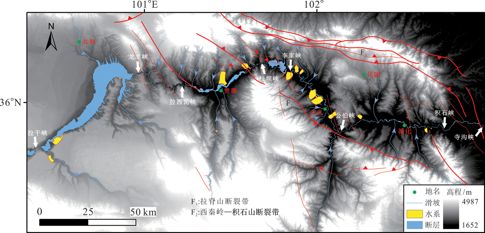
图1 青藏高原东北缘黄河上游地区滑坡空间展布图(据文献[25]修改)
Fig.1 Spatial distribution of landslides in the upper reaches of the Yellow River on the northeast margin of the Tibetan Plateau. Modified after [25].
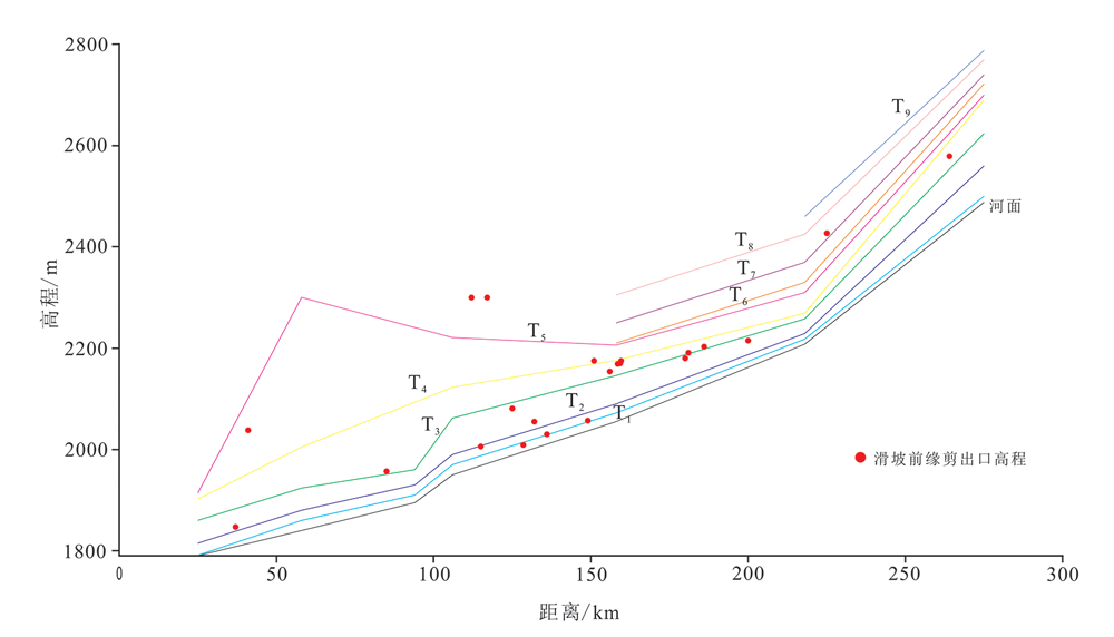
图2 黄河上游河流阶地与巨型滑坡前缘高程分布关系图(T1-T9为河流阶地级数)
Fig.2 Relationship between the elevation profiles of the river terraces and the elevation distribution of the front edge of the super large landslides in the upper reaches of the Yellow River. T1-T9 are the orders of river terraces.
| 序号 | 样品编号 | 滑坡名称 | 滑坡年龄/a | 测年方法 | 资料来源 |
|---|---|---|---|---|---|
| 1 | SGT | 参果滩滑坡 | 24 000±2 000 | ESR | [2] |
| 2 | XZT-1 | 夏藏滩滑坡Ⅰ期 | 49 000±5 000 | ESR | [11] |
| 3 | XZT-2 | 夏藏滩滑坡Ⅱ期 | 28 000±3 000 | ESR | |
| 4 | ASG-1 | 阿什贡滑坡Ⅰ期 | 16 040~15 765 | 14C | [26] |
| 5 | ASG-2 | 阿什贡滑坡Ⅱ期 | 4 490±30 | 14C | [29] |
| 6 | GZ | 革匝滑坡 | 16 040~15 765 | 14C | |
| 7 | SBX | 松坝峡滑坡 | 4 030±30 | 14C | |
| 8 | MRP-3 | 马尔坡滑坡 | 9 100±40 | 14C | [2] |
| 9 | CN | 查纳滑坡 | 1 943 | ||
| 10 | 白刺滩滑坡 | 5 000 | OSL | [4] | |
| 11 | 八大山滑坡 | 4 600±400 | OSL | [3] | |
| 12 | 康杨滑坡前缘 | 33 200±2 500 | OSL | ||
| 13 | 蓆芨滩滑坡Ⅱ期 | 4 900±400 | OSL | ||
| 14 | 唐色村滑坡 | 32 900±2 400 | OSL | ||
| 15 | 察里岗滑坡 | 53 000±4 000 | OSL | ||
| 16 | 扎吉昂滑坡 | 4 572±29 | 14C | ||
| 17 | 支乎且东滑坡 | 9 711±35 | 14C | ||
| 18 | 孟达乡滑坡 | 3 700 | [30] | ||
| 19 | 马尔坡滑坡早期 | 500 000 | [15] | ||
| 20 | 马尔坡滑坡晚期 | 30 000 | |||
| 21 | 虎跳峡巨型滑坡 | 8 250±390 | [16] | ||
| 22 | 锁子滑坡 | 71 000±6 000 | [6] | ||
| 23 | 德恒隆滑坡 | 89 000±8 000 | |||
| 24 | 麦加滑坡 | 38 000±4 000 | [7] |
表1 黄河上游古(老)滑坡发育年代统计表
Table 1 Statistical table of ages of ancient and old landslides in the upper reaches of the Yellow River
| 序号 | 样品编号 | 滑坡名称 | 滑坡年龄/a | 测年方法 | 资料来源 |
|---|---|---|---|---|---|
| 1 | SGT | 参果滩滑坡 | 24 000±2 000 | ESR | [2] |
| 2 | XZT-1 | 夏藏滩滑坡Ⅰ期 | 49 000±5 000 | ESR | [11] |
| 3 | XZT-2 | 夏藏滩滑坡Ⅱ期 | 28 000±3 000 | ESR | |
| 4 | ASG-1 | 阿什贡滑坡Ⅰ期 | 16 040~15 765 | 14C | [26] |
| 5 | ASG-2 | 阿什贡滑坡Ⅱ期 | 4 490±30 | 14C | [29] |
| 6 | GZ | 革匝滑坡 | 16 040~15 765 | 14C | |
| 7 | SBX | 松坝峡滑坡 | 4 030±30 | 14C | |
| 8 | MRP-3 | 马尔坡滑坡 | 9 100±40 | 14C | [2] |
| 9 | CN | 查纳滑坡 | 1 943 | ||
| 10 | 白刺滩滑坡 | 5 000 | OSL | [4] | |
| 11 | 八大山滑坡 | 4 600±400 | OSL | [3] | |
| 12 | 康杨滑坡前缘 | 33 200±2 500 | OSL | ||
| 13 | 蓆芨滩滑坡Ⅱ期 | 4 900±400 | OSL | ||
| 14 | 唐色村滑坡 | 32 900±2 400 | OSL | ||
| 15 | 察里岗滑坡 | 53 000±4 000 | OSL | ||
| 16 | 扎吉昂滑坡 | 4 572±29 | 14C | ||
| 17 | 支乎且东滑坡 | 9 711±35 | 14C | ||
| 18 | 孟达乡滑坡 | 3 700 | [30] | ||
| 19 | 马尔坡滑坡早期 | 500 000 | [15] | ||
| 20 | 马尔坡滑坡晚期 | 30 000 | |||
| 21 | 虎跳峡巨型滑坡 | 8 250±390 | [16] | ||
| 22 | 锁子滑坡 | 71 000±6 000 | [6] | ||
| 23 | 德恒隆滑坡 | 89 000±8 000 | |||
| 24 | 麦加滑坡 | 38 000±4 000 | [7] |
| 滑坡主控因素 | 滑坡类型 | 滑体形态和堆积体特征 | 力学变形模式 | 代表性滑坡 |
|---|---|---|---|---|
| 地震触发 | 以基岩滑坡为主,数量较多 | 滑体较松散,滑体抛掷效应明显,平面形态不规则,岩石块体(土石混合体)有滑动和滚动特征 | 构造控制,滑坡主要沿断裂带展布,且以断裂上盘分布数量居多 | 孟达滑坡、戈龙布滑坡、锁子滑坡、德恒隆滑坡、加仓滑坡、官亭北山滑坡等 |
| 降水诱发 | 黄土滑坡、泥岩滑坡、半固结成岩滑坡、堆积层滑坡 | 滑体表面表现褶皱,多级阶梯状,有明显的水流痕迹,往往能够转化为滑坡碎屑流,在较缓的地形上滑动更远的距离,表面形态较完整 | 降水诱发,与滑动面贯通、堆积体饱和程度密切相关 | 夏藏滩滑坡、夏琼寺滑坡、参果滩滑坡、康杨滑坡、烂泥滩滑坡、支乎具滑坡、阿什贡滑坡、山根滑坡等 |
表2 黄河上游巨型滑坡主控因素分类表
Table 2 Classification of main controlling factors of super large-scale landslides in the upper reaches of the Yellow River
| 滑坡主控因素 | 滑坡类型 | 滑体形态和堆积体特征 | 力学变形模式 | 代表性滑坡 |
|---|---|---|---|---|
| 地震触发 | 以基岩滑坡为主,数量较多 | 滑体较松散,滑体抛掷效应明显,平面形态不规则,岩石块体(土石混合体)有滑动和滚动特征 | 构造控制,滑坡主要沿断裂带展布,且以断裂上盘分布数量居多 | 孟达滑坡、戈龙布滑坡、锁子滑坡、德恒隆滑坡、加仓滑坡、官亭北山滑坡等 |
| 降水诱发 | 黄土滑坡、泥岩滑坡、半固结成岩滑坡、堆积层滑坡 | 滑体表面表现褶皱,多级阶梯状,有明显的水流痕迹,往往能够转化为滑坡碎屑流,在较缓的地形上滑动更远的距离,表面形态较完整 | 降水诱发,与滑动面贯通、堆积体饱和程度密切相关 | 夏藏滩滑坡、夏琼寺滑坡、参果滩滑坡、康杨滑坡、烂泥滩滑坡、支乎具滑坡、阿什贡滑坡、山根滑坡等 |
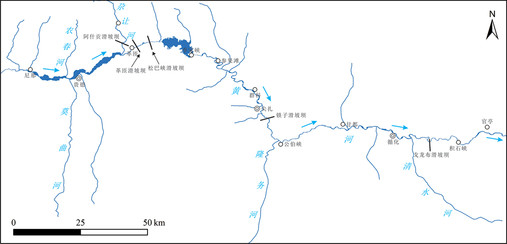
图3 黄河上游古滑坡坝和堰塞湖分布位置图
Fig.3 Distribution of ancient landslide dams and dammed-lakes in the upper reaches of the Yellow River

图4 戈龙布晚期滑坡堰塞坝残留体(a)和上游湖相沉积剖面(b)
Fig.4 Residual masses (a) and upstream lacustrine sedimentary section (b) of the late Gelongbu landslide
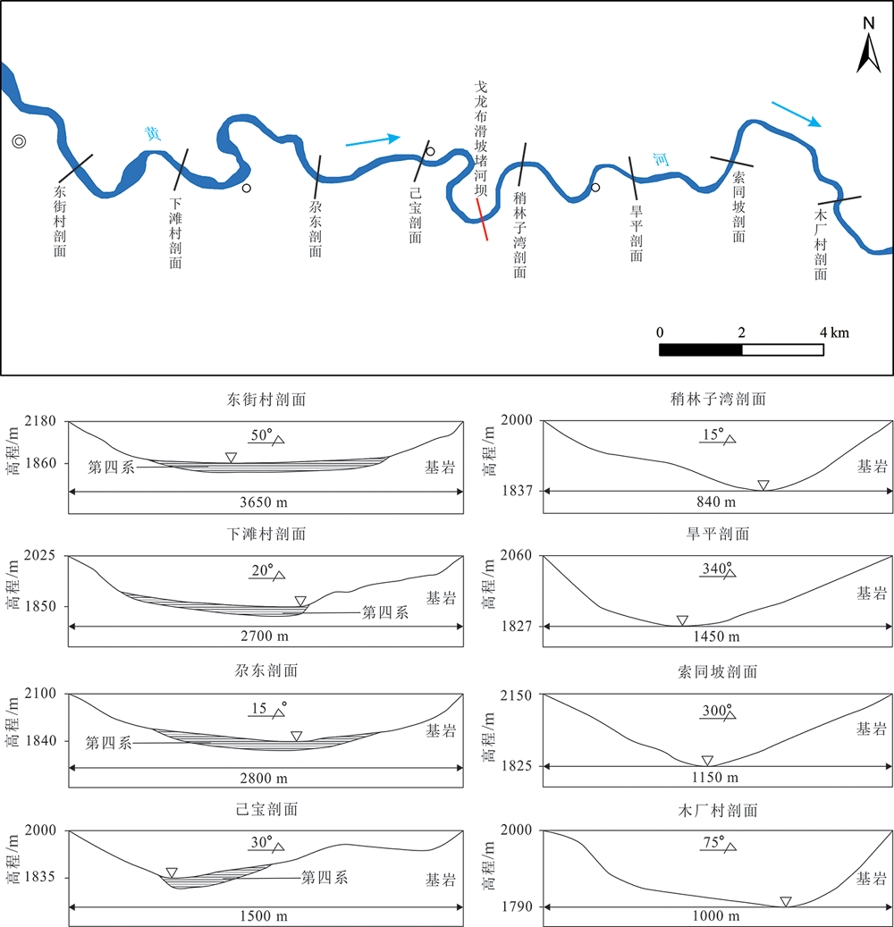
图5 戈龙布晚期滑坡堰塞坝上下游沉积剖面对比图
Fig.5 Comparison of sedimentation profiles in the upper and lower reaches of the late Gelongbu landslide dam

图6 锁子滑坡全貌(a)和次级解体滑坡图(b)
Fig.6 General landform of the Suozi ancient landslide (a) and the secondary disintegration masses (b)

图7 锁子滑坡堰塞坝上下游沉积剖面对比图
Fig.7 Comparison of sedimentation profiles in the upper and lower reaches of the Suozi landslide dam

图8 尖扎盆地锁子滑坡堰塞湖范围与盆地内特大型-巨型滑坡分布图(据文献[10]修改)
Fig.8 The range of the Suozi landslide-dammed lake and distribution of the super-large landslides in the area. Modified after [10].
| [1] | 黄润秋. 中国西部地区典型岩质滑坡机理研究[J]. 第四纪研究, 2003,23(6):640-647. |
| [2] | YIN Z Q, QIN X G, YIN Y P, et al. Landslide developmental characteristics and response to climate change since the last Glacial in the upper reaches of the Yellow River, NE Tibetan Plateau[J]. Acta Geologica Sinica (English edition), 2014,88(2):635-646. |
| [3] | 周保. 黄河上游(拉干峡—寺沟峡段)特大型滑坡发育特征与群发机理研究[D]. 西安: 长安大学, 2010. |
| [4] | 李小林, 郭小花, 李万花. 黄河上游龙羊峡—刘家峡河段巨型滑坡形成机理分析[J]. 工程地质学报, 2011,19(4):516-529. |
| [5] | 殷志强, 程国明, 胡贵寿, 等. 晚更新世以来黄河上游巨型滑坡特征及形成机理初步研究[J]. 工程地质学报, 2010,18(1):41-51. |
| [6] |
GUO X H, LAI Z P, LU Y D, et al. Optically stimulated luminescence (OSL) chronology of the Dehenglong landslide from Longyang gorge to Liujia gorge along Upper Yellow River, China[J]. Acta Geologica Sinica (English Edition), 2015,89(1):242-250.
DOI URL |
| [7] | 赵瑞欣, 周保, 李滨. 黄河上游龙羊峡至积石峡段巨型滑坡OSL测年[J]. 地质通报, 2013,32(12):1943-1951. |
| [8] | 魏刚. 黄河上游龙羊峡至寺沟峡段巨型滑坡分布特征及风险评价研究[D]. 北京: 中国地质大学(北京), 2013. |
| [9] | 张志刚, 白世彪, 王建, 等. 全新世早期黄河上游积石峡大型滑坡堵江事件研究[J]. 干旱区资源与环境, 2013,27(7):102-106. |
| [10] | 殷志强, 许强, 赵无忌, 等. 黄河上游夏藏滩巨型滑坡形成机制及演化过程研究[J]. 第四纪研究, 2016,36(2):474-483. |
| [11] | 赵无忌, 殷志强, 马吉福, 等. 黄河上游贵德盆地席芨滩巨型滑坡发育特征及地貌演化[J]. 地质论评, 2016,62(3) : 709-721. |
| [12] | 殷志强, 秦小光, 赵无忌, 等. 黄河上游官亭盆地红粘土层成因机制再探讨[J]. 第四纪研究, 2013,33(5):995-1004. |
| [13] | 殷志强, 秦小光, 魏刚, 等. 末次冰期以来夏藏滩滑坡湖湖相沉积粒度特征及古气候意义[J]. 第四纪研究, 2017,37(3):624-632. |
| [14] | 郭海婷. 黄河上游戈龙布滑坡及其堰塞湖沉积物光释光年代研究[D]. 南京: 南京师范大学, 2015. |
| [15] | 肖美美. 黄河积石峡堰塞湖与喇家遗址灾难事件的关系研究[D]. 西宁: 青海师范大学, 2018. |
| [16] | 张玉柱, 黄春长, 周亚利, 等. 黄河上游积石峡史前滑坡堰塞湖形成年代与发展演变研究[J]. 中国科学: 地球科学, 2017,47(11):1357-1370. |
| [17] | 郑紫星. 青海喇家遗址全新世气候变化与史前灾难事件研究[D]. 西安: 陕西师范大学, 2018. |
| [18] |
HUANG C C, PANG J L, ZHOU Y L, et al. Palaeoenvironmental implications of the prehistorical catastrophes in relation to the Lajia Ruins within the Guanting basin along the Upper Yellow River, China[J]. The Holocene, 2013,23(11):1584-1595.
DOI URL |
| [19] |
WU Q L, ZHAO Z J, LIU L, et al. Outburst flood at 1920 BCE supports historicity of China’s Great Flood and the Xia dynasty[J]. Science, 2016,353(6299):579-582.
DOI URL |
| [20] |
DONG G H, JIA X, ELSTON R, et al. Spatial and temporal variety of prehistoric human settlement and its influencing factors in the Upper Yellow River valley, Qinghai Province, China[J]. Journal of Archaeological Science, 2013,40(5):2538-2546.
DOI URL |
| [21] | 董广辉, 张帆宇, 刘峰文, 等. 喇家遗址史前灾害与黄河大洪水无关[J]. 中国科学: 地球科学, 2018,48(4):467-475. |
| [22] | 李珅熠. 黄河峡谷龙羊峡—拉西瓦段右岸坡稳定性研究[D]. 西安: 西安工业大学, 2018. |
| [23] |
ZHANG D X, WANG G H, YANG T, et al. Satellite remote sensing-based detection of the deformation of a reservoir bank slope in Laxiwa Hydropower Station, China[J]. Landslides, 2013,10(2):231-238.
DOI URL |
| [24] | 史立群, 魏刚, 殷志强, 等. 青海尖扎盆地寺门村滑坡发育特征及成因分析[J]. 中国地质灾害与防治学报, 2020,31(5):15-21. |
| [25] | 殷志强, 秦小光, 赵无忌, 等. 基于多元遥感影像数据的黄河上游滑坡发育特征研究[J]. 工程地质学报, 2013,21(5):779-787. |
| [26] | 魏刚, 殷志强, 马吉福, 等. 黄河上游阿什贡滑坡群发育期次及演化过程分析[J]. 水文地质工程地质, 2016,43(6):133-140, 153. |
| [27] | 殷志强. 黄河上游中段巨型滑坡时空分布、演化过程与主控因素研究[D]. 北京: 中国科学院大学, 2014. |
| [28] | 陈剑, 李晓, 杨志法. 三峡库区滑坡的时空分布特征与成因探讨[J]. 工程地质学报, 2005,13(3):305-309. |
| [29] | 魏占玺, 马文礼, 肖建兵, 等. 黄河上游松坝峡特大型滑坡堰塞湖及地貌效应研究[J]. 中国地质灾害与防治学报, 2017,28(3):16-23. |
| [30] | 刘高, 刘从友, 王有林, 等. 黄河某水电站顺层岩质滑坡形成机理与演化过程[J]. 西北地震学报, 2008,30(3):249-254. |
| [31] | 彭建兵, 马润勇, 卢全中, 等. 青藏高原隆升的地质灾害效应[J]. 地球科学进展, 2004,19(3):457-466. |
| [32] | 赵振明, 刘百篪. 青海共和至甘肃兰州黄河河谷地貌的形成与青藏高原东北缘隆升的关系[J]. 西北地质, 2003,36(2):1-12. |
| [33] | 殷志强. 黄河上游滑坡泥石流时空演化及触发机制[M]. 北京: 科学出版社, 2016. |
| [34] | 郭小花. 龙羊峡—刘家峡河段巨型滑坡堵河事件与黄河演化之间的关系[D]. 西安: 长安大学, 2017. |
| [35] | 郭小花. 黄河上游龙羊峡—刘家峡河段巨型滑坡光释光测年[D]. 兰州: 兰州大学, 2012. |
| [36] |
YIN Z Q, QIN X Q, ZHAO W J. Distribution characteristics of geohazards induced by the Lushan earthquake and their comparisons with the Wenchuan earthquake[J]. Journal of Earth Science, 2014,25(5):912-923.
DOI URL |
| [37] | 周洪福, 韦玉婷, 聂德新. 黄河上游戈龙布滑坡高速下滑成因机制及堵江分析[J]. 工程地质学报, 2009,17(4):483-488. |
| [38] | 殷志强, 赵无忌, 李小林, 等. 黄河上游戈龙布滑坡堵河事件及堰塞湖沉积物研究[J]. 地质学报, 2013,87(增刊):311-313. |
| [39] | 吴庆龙, 张培震, 张会平, 等. 黄河上游积石峡古地震堰塞溃决事件与喇家遗址异常古洪水灾害[J]. 中国科学: D 辑, 2009,39(8):1148-1159. |
| [40] |
ZHANG F Y, LIU G, CHEN W W, et al. Engineering geology and stability of the Jishixia landslide, Yellow River, China[J]. Bulletin of Engineering Geology and the Environment, 2010,69:99-103.
DOI URL |
| [41] |
ZHANG Y Z, HUANG C C, SHULMEISTER J, et al. Formation and evolution of the Holocene massive landslide-dammed lakes in the Jishixia gorges along the upper Yellow River: no relation to China’s Great Flood and the Xia dynasty[J]. Quaternary Science Reviews, 2019,218:267-280.
DOI URL |
| [42] |
ZHANG Y Z, HUANG C C, PANG J L, et al. OSL dating of the massive landslide damming event in the Jishixia gorge, on the upper Yellow River, NE Tibetan Plateau[J]. The Holocene, 2015,25(5):745-757.
DOI URL |
| [43] | QIN X G, YIN Z Q, ZHAO W J. Xijitan landslide in Guide Basin in the upper reaches of the Yellow River and its dammed lakes[J]. Journal of Geophysics Remote Sensing, 2015,4(3):1000147. |
| [44] | 李乾坤, 徐则民, 张家明. 永胜金沙江寨子村古滑坡和古堰塞湖的发现[J]. 山地学报, 2011,29(6):729-737. |
| [45] | 徐则民. 金沙江寨子村滑坡坝堰塞湖沉积及其对昔格达组地层成因的启示[J]. 地质论评, 2011,57(5):675-686. |
| [46] |
ZHAO W J, YIN Z Q, XU Q, et al. Formation mechanism and their geomorphic evolution process of Erlian Mudflow fans in eastern Guide Basin of the upper reaches of Yellow River[J]. Acta Geologica Sinica, 2016,90(2):578-589.
DOI URL |
| [47] | 殷志强, 魏刚, 秦小光, 等. 青藏高原东北缘循化—官亭地区2.6万年以来气候变化研究[J]. 第四纪研究, 2019,39(5):1181-1190. |
| [48] | 秦小光, 殷志强, 汪美华, 等. 青藏高原东北缘共和—贵德盆地全新世气候变化[J]. 地质学报, 2017,91(1):266-286. |
| [49] | 鹿化煜, 王先彦, 孙雪峰, 等. 钻探揭示的青藏高原东北部黄土地层与第四纪气候变化[J]. 第四纪研究, 2007,27(2):230-241. |
| [50] | 潘保田, 王建民. 末次间冰期以来青藏高原东部季风演化的黄土沉积记录[J]. 第四纪研究, 1999,19(4):330-335. |
| [51] | 谢远云, 李长安, 张序强, 等. 青藏高原东北缘黄土的气候演化与高原隆升的耦合[J]. 中国地质, 2003,30(4):436-441. |
| [52] |
TAN L C, SHEN C C, CAI Y J, et al. Great flood in the middle-lower Yellow River reaches at 4000 a BP inferred from accurately-dated stalagmite records[J]. Science Bulletin, 2018,63(4):206-208.
DOI URL |
| [1] | 陈剑, 陈瑞琛, 崔之久. 高速远程滑坡的地貌学与沉积学研究进展[J]. 地学前缘, 2021, 28(4): 349-360. |
| [2] | 白世彪, 崔鹏, 葛永刚, 王昊. 古滑坡测年方法与定年精度的提高途径[J]. 地学前缘, 2021, 28(2): 19-34. |
| [3] | 范宣梅, 戴岚欣, 钟育瑾, 李婧娟, 王兰生. 岷江上游叠溪古滑坡坝-堰塞湖研究进展[J]. 地学前缘, 2021, 28(2): 71-84. |
| [4] | 陈剑, 崔之久, 陈瑞琛, 郑欣欣. 金沙江上游特米古滑坡堰塞湖成因与演化[J]. 地学前缘, 2021, 28(2): 85-93. |
| [5] | 张永双, 刘筱怡, 吴瑞安, 郭长宝, 任三绍. 青藏高原东缘深切河谷区古滑坡:判识、特征、时代与演化[J]. 地学前缘, 2021, 28(2): 94-105. |
| [6] | 王玉峰, 程谦恭, 林棋文, 李坤, 史安文. 青藏高原古高速远程滑坡沉积学特征研究[J]. 地学前缘, 2021, 28(2): 106-124. |
| [7] | 黄小龙, 吴中海, 刘锋, 田婷婷, 黄小巾, 张铎. 滇西北程海断裂带主要古地震滑坡及其分布特征的构造解释[J]. 地学前缘, 2021, 28(2): 125-139. |
| [8] | 孙启良, 解习农, 吴时国. 南海北部海底滑坡的特征、灾害评估和研究展望[J]. 地学前缘, 2021, 28(2): 258-270. |
| [9] | 彭博, 刘成林, 祁柯宁, 刘大鹏, 王嘉琦, 李宗星, 马寅生, 胡俊杰. 柴达木盆地东部上泥盆统—下石炭统沉积分异特征及其主控因素讨论[J]. 地学前缘, 2021, 28(1): 104-114. |
| [10] | 张满郎, 郭振华, 张林, 付晶, 郑国强, 谢武仁, 马石玉. 四川安岳气田龙王庙组颗粒滩岩溶储层发育特征及主控因素[J]. 地学前缘, 2021, 28(1): 235-248. |
| [11] | 唐华风, 王寒非, BenKENNEDY, 张芯语, MarcosROSSETTI, AlanPatrickBISCHOFF, AndrewNICOL. 水下喷发火山碎屑岩储层特征及主控因素:以新西兰Taranaki盆地中新世Kora火山为例[J]. 地学前缘, 2021, 28(1): 375-387. |
| [12] | 曾维特,丁文龙,张金川,李玉喜,王濡岳,久凯. 渝东南—黔北地区牛蹄塘组页岩微纳米级孔隙发育特征及主控因素分析 [J]. 地学前缘, 2019, 26(3): 220-235. |
| [13] | 陈晓利, 单新建, 张凌, 刘春国, 韩娜娜, 兰剑. 地震诱发滑坡的快速评估方法研究:以2017年MS7.0级九寨沟地震为例[J]. 地学前缘, 2019, 26(2): 312-320. |
| [14] | 肖萌,袁选俊,吴松涛,曹正林,唐勇,谢宗瑞,王瑞菊. 准噶尔盆地玛湖凹陷百口泉组砾岩储层特征及其主控因素[J]. 地学前缘, 2019, 26(1): 212-224. |
| [15] | 田雨,徐洪,张兴阳,王红军,张良杰,张宏伟,郭同翠,尉晓玮. 碳酸盐岩台内滩储层沉积特征、分布规律及主控因素研究:以阿姆河盆地台内滩气田为例[J]. 地学前缘, 2017, 24(6): 312-321. |
| 阅读次数 | ||||||
|
全文 |
|
|||||
|
摘要 |
|
|||||