地学前缘 ›› 2022, Vol. 29 ›› Issue (2): 402-415.DOI: 10.13745/j.esf.sf.2022.2.2
所属专题: 印度-欧亚大陆碰撞及其远程效应
• “印度-欧亚大陆碰撞及其远程效应”专栏之四 • 上一篇 下一篇
吴国炜1( ), 熊小松1,2,*(), 高锐3, 陈宣华1, 李英康4, 王冠2, 王小成5, 任海东6
收稿日期:2022-01-30
修回日期:2022-02-08
出版日期:2022-03-25
发布日期:2022-03-31
通信作者:
熊小松
作者简介:吴国炜(1995—),男,硕士研究生,主要从事大陆岩石圈的结构与演化研究。E-mail: wuguowei19@mails.ucas.ac.cn
基金资助:
WU Guowei1(), XIONG Xiaosong1,2,*(), GAO Rui3, CHEN Xuanhua1, LI Yingkang4, WANG Guan2, WANG Xiaocheng5, REN Haidong6
Received:2022-01-30
Revised:2022-02-08
Online:2022-03-25
Published:2022-03-31
Contact:
XIONG Xiaosong
摘要:
花海盆地—北山构造带南部位于青藏高原东北缘以北地区,是特提斯洋和古亚洲洋两大构造域的交接部位,自新元古代晚期以来经历了多期次、多阶段的板块裂解-俯冲-碰撞-拼合的演化历史,尤其是中生代以来的逆冲推覆和走滑作用,以及受新生代以来印度板块和欧亚板块碰撞的远程效应影响,导致青藏高原东北缘的向北扩展,形成了现今复杂的地质地貌结构。其地壳结构记录了多期构造作用的叠加,上地壳结构更是促进我们理解青藏高原东北缘向外的扩展机制及其对周缘块体的改造作用的天然记录本。本文利用2018年中国地质科学院在北山构造带南部完成的180 km深反射地震剖面的初至波(Pg震相)数据,通过层析成像反演方法,获得了花海盆地—北山构造带4 km深度范围内的上地壳P波速度结构。其主要特征为:花海盆地、总口子盆地和扎格高脑盆地均表现为较低的速度和较小的垂向速度梯度;研究区内的晚古生代花岗岩体具有明显的高速异常和较大的垂向速度梯度特征;左行走滑的阿尔金断裂带在花海盆地内表现为向北倾的高角度走滑性质,深度至少切穿花海盆地基底;北山南缘断裂带的推测隐伏区呈现速度等值线下凹的低速异常特征。同时,反演揭示的多处低速异常区指示了北山构造带南部的多处断层发育情况。
中图分类号:
吴国炜, 熊小松, 高锐, 陈宣华, 李英康, 王冠, 王小成, 任海东. 北山构造带南部上地壳二维初至波层析成像[J]. 地学前缘, 2022, 29(2): 402-415.
WU Guowei, XIONG Xiaosong, GAO Rui, CHEN Xuanhua, LI Yingkang, WANG Guan, WANG Xiaocheng, REN Haidong. 2D Tomographic imaging of the P-wave velocity structure in the upper crust beneath the southern Beishan tectonic belt[J]. Earth Science Frontiers, 2022, 29(2): 402-415.
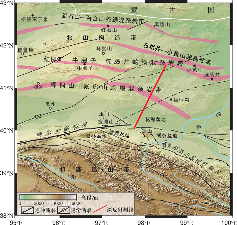
图1 深反射地震测线位置图及研究区主要地质构造(据文献[1]修改)
Fig.1 Geological map of the study area showing the location of the deep seismic reflection profile (survey line in red line)and the geological structure of the area. Modified after [1].

图2 花海盆地—北山构造带地质简图 图中蓝色线为花海—北山深反射剖面,黑色数字为对应白色点至剖面南端的距离。
Fig.2 Simplified geological map of the Huahai Basin-Beishan tectonic belt. Blue line is the survey line of the deep reflection profile, where the numbers indicate the distance between the sampling points and the south end of the profile.
图3 初至波走时层析成像数据处理的基本流程
Fig.3 Flowchart of seismic wave travel tomography data processing
| 震源类型 | 炸药量/kg | 炮间距/m | 井深/m | 井数 | 道间距/m | 接收道数 |
|---|---|---|---|---|---|---|
| 中炮 | 150 | 960 | 45 | 2 | 40 | 960 |
| 小炮 | 48 | 240 | 33 | 1 | 40 | 960 |
表1 采集参数表
Table 1 Data sampling parameters
| 震源类型 | 炸药量/kg | 炮间距/m | 井深/m | 井数 | 道间距/m | 接收道数 |
|---|---|---|---|---|---|---|
| 中炮 | 150 | 960 | 45 | 2 | 40 | 960 |
| 小炮 | 48 | 240 | 33 | 1 | 40 | 960 |

图4 单炮记录初至拾取 图中红色线为拾取的初至到时。
Fig.4 First arrival pickup of single shot records. Red line indicates the first arrival time of the pickup for all channels
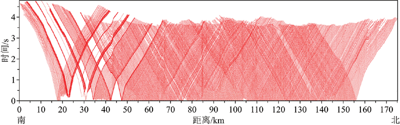
图5 所有单炮记录的初至拾取结果
Fig.5 First-arrival pickup results of all single-shot records
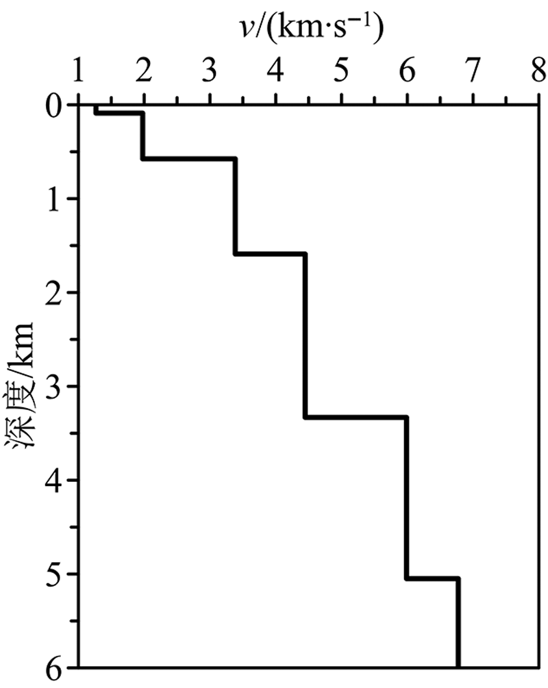
图6 初始一维速度模型
Fig.6 Initial 1D velocity model
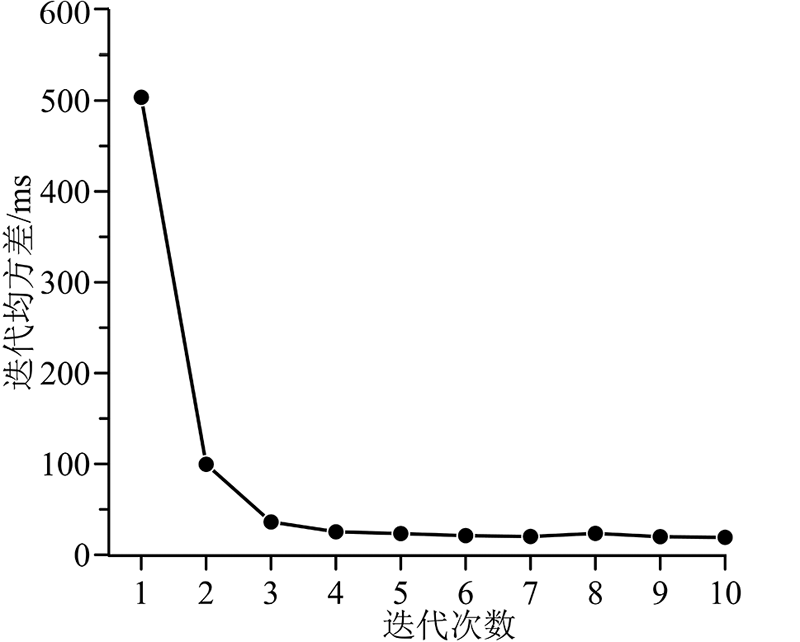
图7 层析反演的迭代收敛曲线
Fig.7 Iterative convergence curve for tomographic inversion
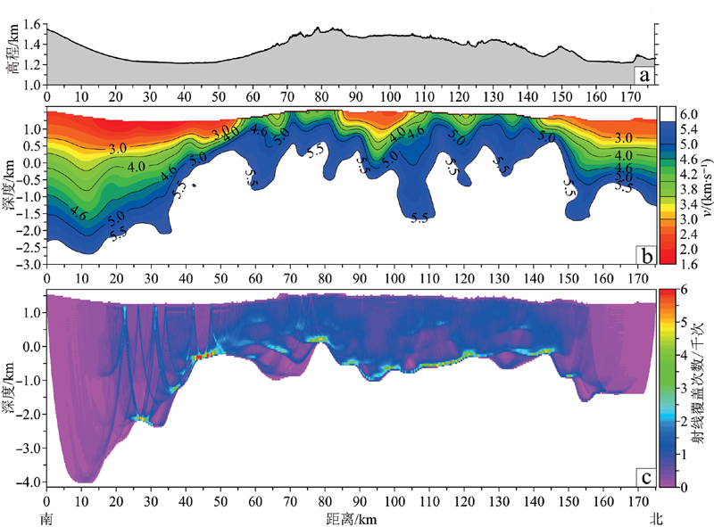
图8 沿测线高程(a)、层析反演的速度结构(b)和层析反演的射线密度分布图(c)
Fig.8 Plot of the elevation along the survey line (a), the velocity structure of the tomographic inversion (b) and the ray density distribution map of the tomographic inversion (c)

图9 拾取初至走时(a)、最终模型的拟合走时(b)和拾取走时与拟合走时对比图(c) 图中红色线为拾取走时,蓝色线为最终模型拟合走时。
Fig.9 Plots of first arrival travel time (a) and fitted travel time from the final model (b) vs. survey distance, and superposition of the two plots (c)
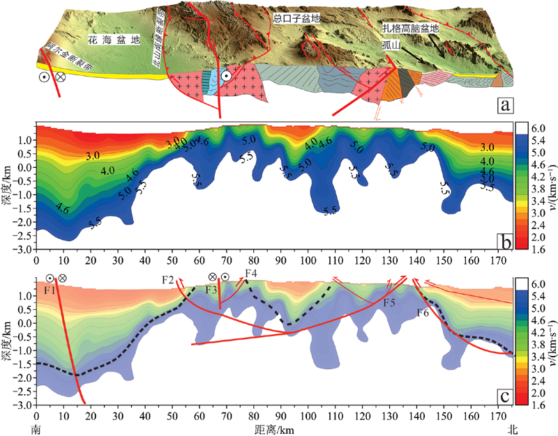
图10 沿测线地形图(a)、反演得到的速度剖面图(b)和速度剖面解释图(c) 图中黑色虚线为推测的盆地结晶基底顶部位置,红色实线和为推测的断层。
Fig.10 (a) Topographic map along the survey line, (b) velocity profile obtained by inversion, and (c) interpretation of the velocity profile. In c the black dotted line indicates the inferred position of the top of the crystalline basement in the basin, and red solid line the inferred fault.
| [1] |
XIAO W, MAO Q G, WINDLEY B F, et al. paleozoic multiple accretionary and collisional processes of the beishan orogenic collage[J]. American Journal of Science, 2010, 310:1553-1594.
DOI URL |
| [2] | 郑荣国, 吴泰然, 肖文交, 等. 北山北部双井子复式岩体年代学、地球化学及其大地构造意义[J]. 地质学报, 2016, 90(11):3153-3172. |
| [3] |
MOLNAR P, ENGLAND P, MARTINOD J. Mantle dynamics, uplift of the Tibetan Plateau, and the Indian Monsoon[J]. Reviews of Geophysics, 1993, 31(4):357-396.
DOI URL |
| [4] |
MOLNAR P, TAPPONNIER P. Cenozoic Tectonics of Asia:effects of a continental collision[J]. Science, 1975, 189(4201):419-426.
DOI URL |
| [5] |
TAPPONNIER P, XU Z, FRANCOISE R, et al. Oblique stepwise rise and growth of the Tibet Plateau[J]. Science, 2001, 294(5547):1671-1677.
DOI URL |
| [6] |
YIN A, RUMELHART P E, BUTLER R, et al. Tectonic history of the Altyn Tagh fault system in northern Tibet inferred from Cenozoic sedimentation[J]. Geological Society of America Bulletin, 2002, 114(10):1257-1295.
DOI URL |
| [7] | 张进, 李锦轶, 李彦峰, 等. 阿拉善地块新生代构造作用: 兼论阿尔金断裂新生代东向延伸问题[J]. 地质学报, 2007, 81(11):1481-1497. |
| [8] | 郑亚东, 张青, 王玉芳, 等. 北山-南戈壁地区侏罗纪巨型逆冲推覆体[J]. 内蒙古地质, 1998(4):1-12. |
| [9] | 左国朝, 冯永忠, 刘春燕, 等. 内蒙古北山中南新发现燕山早期走滑挤压推覆构造带[J]. 地质科学, 1992(4):309-316. |
| [10] |
XIAO Q, SHAO G, ZENG J, et al. Eastern termination of the Altyn Tagh Fault, western China: constraints from a magnetotelluric survey[J]. Journal of Geophysical Research: Solid Earth, 2015, 120:2838-2858.
DOI URL |
| [11] | BROWN L, BARAZANGI M, KAUFMAN S, et al. The first decade of COCORP: 1974-1984[J]. Reflection Seismology: A Global Perspective, 1986, 13:107-120. |
| [12] | 卢占武, 高锐, 李秋生, 等. 中国青藏高原深部地球物理探测与地球动力学研究[J]. 地球物理学报, 2006, 49(3):753-770. |
| [13] | 高锐, 熊小松, 李秋生, 等. 由地震探测揭示的青藏高原莫霍面深度[J]. 地球学报, 2009, 30(6):761-773. |
| [14] | 熊小松, 高锐, 李秋生, 等. 深地震探测揭示的西北地区莫霍面深度[J]. 地球学报, 2010, 31(1):23-31. |
| [15] |
HOU H, WANG H, GAO R, et al. Fine crustal structure and deformation beneath the Great Xing’an Ranges, CAOB: revealed by deep seismic reflection profile[J]. Journal of Asian Earth Sciences, 2015, 113:491-500.
DOI URL |
| [16] |
XIONG X, GAO R, LI Y, et al. The lithosphere structure of the Great Xing’an Range in the eastern Central Asian Orogenic Belt: constrains from the joint geophysical profiling[J]. Journal of Asian Earth Sciences, 2015, 113:481-490.
DOI URL |
| [17] | 常旭, 王辉. 地震法隐伏矿脉空间定位研究[J]. 地球物理学报, 1998, 41(3):408-415. |
| [18] | 林伯香, 孙晶梅, 刘清林. 层析成像低速带速度反演和静校正方法[J]. 石油物探, 2002, 41(2):136-140. |
| [19] | 史大年, 吕庆田, 徐明才, 等. 铜陵矿集区地壳浅表结构的地震层析研究[J]. 矿床地质, 2004, 23(3):383-389. |
| [20] | 宋桂桥, 尹天奎, 刘连升. 关于塔里木沙漠区低速带调查重新定位的思考[J]. 石油物探, 2008, 47(4):372-375. |
| [21] | 张先康, 杨卓欣, 徐朝繁, 等. 阿尼玛卿缝合带东段上地壳结构: 马尔康—碌曲—古浪深地震测深剖面结果[J]. 地震学报, 2007, 29(6):592-604. |
| [22] | 嘉世旭, 张先康. 青藏高原东北缘深地震测深震相研究与地壳细结构[J]. 地球物理学报, 2008, 51(5):1431-1443. |
| [23] | 徐涛, 张明辉, 田小波, 等. 丽江—清镇剖面上地壳速度结构及其与鲁甸Ms6.5级地震孕震环境的关系[J]. 地球物理学报, 2014, 57(9):3069-3079. |
| [24] | 林吉焱, 段永红. 海原构造区及其周缘上部地壳结构研究[J]. 地震学报, 2016, 38(2):179-187. |
| [25] | 张明辉, 刘有山, 侯爵, 等. 近地表地震层析成像方法综述[J]. 地球物理学进展, 2019, 34(1):48-63. |
| [26] | 林吉焱, 唐国彬, 徐涛, 等. 钦杭—武夷山成矿带上地壳速度结构与基底特征: 万载—惠安宽角反射/折射地震剖面约束[J]. 地球物理学报, 2020, 63(12):4396-4409. |
| [27] | 吕庆田, 姜枚, 许志琴, 等. 印度板块俯冲仅到特提斯喜马拉雅之下的地震层析证据[J]. 科学通报, 1998, 43(12):1308-1311. |
| [28] | 吴建平, 明跃红, 叶太兰, 等. 体波波形反演对青藏高原上地幔速度结构的研究[J]. 地球物理学报, 1998, 41(增刊):15-25. |
| [29] | 郑洪伟, 李廷栋, 高锐, 等. 印度板块岩石圈地幔向北俯冲到羌塘地体之下的远震P波层析成像证据[J]. 地球物理学报, 2007, 50(5):1418-1426. |
| [30] | 王冠, 熊小松, 高锐, 等. 花海盆地深地震反射剖面的最佳采集参数实验和分析[J]. 中国地质, 2019, 46(5):210-224. |
| [31] | 任战利, 张小会, 刘池洋, 等. 花海-金塔盆地生油岩古温度的确定指明了油气勘探方向[J]. 科学通报, 1995, 40(10):921-923. |
| [32] | 李明杰, 郑孟林, 曹春潮, 等. 北山—阿拉善地区侏罗—白垩纪盆地的叠合演化[J]. 石油与天然气地质, 2004, 25(1):54-57. |
| [33] | 党犇, 赵虹. 北山盆地群砂岩储层特征及分类评价[J]. 地球科学与环境学报, 1998, 20(增刊):39-43. |
| [34] | 仁和爱, 李刚. 北山地区总口子盆地油气勘探方向[J]. 海洋地质前沿, 2005, 21(4):24-27. |
| [35] | 吴少波, 白玉宝. 北山盆地群侏罗—白垩系生储盖特征及油气远景[J]. 地质科学, 2006, 41(1):1-9. |
| [36] | 卢进才, 陈高潮, 李玉宏. 银额盆地及部区石炭系—二叠系油气地质条件与资源前景[M]. 北京: 地质出版社, 2012. |
| [37] | 毛启贵. 北山及邻区古生代—早中生代增生与碰撞大地构造格局[D]. 北京: 中国科学院地质与地球物理研究所, 2008. |
| [38] | 彭楠, 柳永清, 旷红伟, 等. 北祁连—北山地区早白垩世盆地物源分析: 来自古水流、砾石组分、砂岩组分和碎屑锆石年龄的证据[J]. 地质通报, 2003, 32(2/3):456-475. |
| [39] | 王国强. 北山古生代蛇绿岩、火山岩研究与构造演化[D]. 西安: 长安大学, 2015: 1-124. |
| [40] | 王国强, 李向民, 徐学义. 甘肃北山红石山蛇绿岩锆石U-Pb年代学研究及构造意义[J]. 岩石学报, 2004, 30(6):1685-1694. |
| [41] | 左国朝, 何国琦. 北山板块构造及成矿规律[M]. 北京: 北京大学出版社, 1990: 1-226. |
| [42] | 何世平, 周会武, 任秉琛, 等. 甘肃内蒙古北山地区古生代地壳演化[J]. 西北地质, 2005, 38(3):6-15. |
| [43] | 杨合群, 李英, 赵国斌, 等. 北山蛇绿岩特征及构造属性[J]. 西北地质, 2010, 43(1):26-36. |
| [44] | 李向民, 余吉远, 王国强, 等. 甘肃北山地区芨芨台子蛇绿岩LA-ICP-MS锆石U-Pb测年及其地质意义[J]. 地质通报, 2012, 31(12):2025-2031. |
| [45] |
SONG D, XIAO W, WINDLEY B F, et al. A Paleozoic Japan-type subduction-accretion system in the Beishan orogenic collage, southern Central Asian Orogenic Belt[J]. Lithos, 2015, 224/225:195-213.
DOI URL |
| [46] |
SHI Y, LI L, KRONER A, et al. Carboniferous Alaskan-type complex along the Sino-Mongolian boundary, southern margin of the Central Asian Orogenic Belt[J]. Acta Geochimica, 2017, 36(2):276-290.
DOI URL |
| [47] | 孙立新, 张家辉, 任邦方, 等. 北山造山带白云山蛇绿混杂岩的地球化学特征、时代及地质意义[J]. 岩石矿物学杂志, 2017, 36(2):131-147. |
| [48] |
AO S J, XIAO W, HAN C, et al. Cambrian to early Silurian ophiolite and accretionary processes in the Beishan collage, NW China: implications for the architecture of the Southern Altaids[J]. Geological Magazine, 2012, 149(4):606-625.
DOI URL |
| [49] | 宋东方, 肖文交, 韩春明, 等. 北山中部增生造山过程: 构造变形40Ar-39Ar年代学制约[J]. 岩石学报, 2018, 34(7):2087-2089. |
| [50] | 魏志军, 黄增保, 金霞, 等. 甘肃红石山地区蛇绿混杂岩地质特征[J]. 西北地质, 2004, 37(1):13-18. |
| [51] | 黄增保, 金霞. 甘肃北山红石山蛇绿混杂岩带中基性火山岩构造环境分析[J]. 中国地质, 2006, 33(5):1030-1037. |
| [52] | 任云伟, 任邦方, 牛文超, 等. 内蒙古哈珠地区石炭纪白山组火山岩: 北山北部晚古生代活动陆缘岩浆作用的产物[J]. 地球科学, 2019, 44(1):312-327. |
| [53] | 赵志雄, 熊煜, 贾元琴, 等. 北山独龙包地区晚石炭世陆缘弧岩浆作用: 花岗闪长岩锆石U-Pb年龄及地球化学证据[J]. 地质论评, 2018, 64(3):579-509. |
| [54] | 张培震, 邓起东, 张国民, 等. 中国大陆的强震活动与活动地块[J]. 中国科学: D辑, 2003, 33(增刊):12-20. |
| [55] | 刘永江, 葛肖虹, GENSER J, 等. 阿尔金断裂带构造活动的40Ar/39Ar年龄证据[J]. 科学通报, 2003, 48(12):1335-1341. |
| [56] | ZHANG P, MOLNAR P, XU X, et al. Late Quaternary and present-day rates of slip along the Altyn Tagh Fault, northern margin of the Tibetan Plateau[J]. Tectonics, 2007, 26(5):1-24. |
| [57] |
ZHENG W, ZHANG P, HE W, et al. Transformation of displacement between strike-slip and crustal shortening in the northern margin of the Tibetan Plateau: evidence from decadal GPS measurements and late Quaternary slip rates on faults[J]. Tectonophysics, 2013, 584:267-280.
DOI URL |
| [58] |
TAPPONNIER P, XU Z, FRANCOISE R, et al. Oblique stepwise rise and growth of the Tibet Plateau[J]. Science, 2001, 294(5547):1671-1677.
DOI URL |
| [59] |
DARBY B J, RITTS B D, YUE Y, et al. Did the Altyn Tagh fault extend beyond the Tibetan Plateau?[J]. Earth and Planetary Science Letters, 2005, 240:425-435.
DOI URL |
| [60] | 陈文彬, 徐锡伟. 阿拉善地块南缘的左旋走滑断裂与阿尔金断裂带的东延[J]. 地震地质, 2006, 28(2):319-324. |
| [61] |
YUE Y, LIOU J G. Two-stage evolution model for the Altyn Tagh fault, China[J]. Geology, 2015, 27(3):227-230.
DOI URL |
| [62] | 李文辉. 深地震反射与深地震测深联合探测及其在地壳结构研究中的应用[D]. 北京: 中国地质科学院, 2013. |
| [63] | 薛为平, 宋阳, 刘居文, 等. 准噶尔盆地石南地区静校正方法应用研究[J]. 石油勘探, 2006, 45(6):615-618. |
| [64] |
CHRISTENSEN N I, MOONEY W D. Seismic velocity structure and composition of the continental crust: a global view[J]. Journal of Geophysical Research Atmospheres, 1995, 100(B6):9761-9788.
DOI URL |
| [65] | 王夫运, 徐锡伟, 刘宝峰, 等. 川西盐源—马边地震带上地壳速度结构和活动断裂研究: 高分辨率地震折射实验结果[J]. 中国科学: D辑, 2008, 38(5):611-621. |
| [66] | 郭文斌, 嘉世旭, 段永红, 等. 青藏高原东北缘基底结构研究: 玛多—共和—雅布赖剖面上地壳地震折射探测[J]. 地球物理学报, 2006, 59(10):3627-3636. |
| [67] | 李培, 蔡辉腾, 金星, 等. 中国大陆东南缘主要构造带基底结构[J]. 地球物理学报, 2019, 62(8):2991-3003. |
| [68] | 聂凤军, 江思宏, 赵省民, 等. 北山地区金属矿床成矿规律及找矿方向[M]. 北京: 地质出版社, 2002. |
| [69] | 李舢, 王涛, 童英, 等. 北山辉铜山泥盆纪钾长花岗岩锆石U-Pb年龄、成因及构造意义[J]. 岩石学报, 2011, 27(10):3055-3070. |
| [70] |
LI S, WANG T, WILDE S A, et al. Geochronology, petrogenesis and tectonic implications of Triassic granitoids from Beishan, NW China[J]. Lithos, 2012, 134/135:123-145.
DOI URL |
| [71] |
MAO Q, XIAO W, FANG T, et al. Late Ordovician to early Devonian adakites and Nb-enriched basalts in the Liuyuan area, Beishan, NW China: implications for early Paleozoic slab-melting and crustal growth in the southern Altaids[J]. Gondwana Research, 2012, 22:534-553.
DOI URL |
| [72] | ZHANG W, PEASE V, WU T, et al. Discovery of an adakite-like pluton near Dongqiyishan (Beishan, NW China): its age and tectonic significance[J]. Lithos, 2012, 142:148-160. |
| [73] |
LI S, WILDE S A, WANG T. Early Permian post-collisional high-K granitoids from Liuyuan area in southern Beishan orogen, NW China: petrogenesis and tectonic implications[J]. Lithos, 2013, 179:99-119.
DOI URL |
| [74] | 何光玉, 韩永科, 李建立, 等. 阿尔金断裂花海段新生代变形特征及时间[J]. 地质科学, 2007, 41(1):84-90. |
| [75] | 云龙, 张进, 徐伟, 等. 甘肃北山南缘断裂的活动特征及其意义[J]. 地质评论, 2019, 65(4):825-838. |
| [1] | 刘晓宇, 杨文采, 陈召曦, 瞿辰, 于常青. 青藏高原东部地块的属性与演化[J]. 地学前缘, 2023, 30(3): 233-241. |
| [2] | 崔鑫, 宋秀青, 石耀霖, 殷海涛, 朱元清, 董腾超. 沂沭断裂带及其邻区地壳P波层析成像研究[J]. 地学前缘, 2023, 30(2): 272-281. |
| [3] | 高福建, 邹志辉, 王永红. 基于地震层析速度模型分析海滩地下结构:以青岛石老人海水浴场为例[J]. 地学前缘, 2022, 29(5): 275-284. |
| [4] | 李文辉, 王海燕, 高锐, 卢占武, 李洪强, 侯贺晟, 熊小松, 叶卓. 秦岭造山带及邻区上地壳精细速度结构研究[J]. 地学前缘, 2022, 29(2): 198-209. |
| [5] | 梁锋,吕庆田,严加永,刘振东. 宁芜盆地深部地壳结构和岩浆侵入体形态特征及其对成矿的启示[J]. 地学前缘, 2017, 24(5): 138-148. |
| [6] | 韦伟,许建东,于红梅. 西昆仑阿什库勒火山的起源:来自地震层析成像的证据[J]. 地学前缘, 2015, 22(6): 227-232. |
| [7] | 徐峣,张贵宾,江国明,索奎,姚永波. 中国东北地区三维速度结构与火山起源的深部机制[J]. 地学前缘, 2014, 21(4): 255-265. |
| [8] | 瞿辰, 杨文采, 于常青. 塔里木盆地地震波速扰动及泊松比成像[J]. 地学前缘, 2013, 20(5): 196-206. |
| [9] | 杨文采,瞿辰,于常青. 华北东部地区地壳泊松比异常及其成因[J]. 地学前缘, 2011, 18(3): 13-21. |
| [10] | 韦伟, 赵大鹏, 石耀霖. 西南日本火山区三维地震成像研究[J]. 地学前缘, 2010, 17(3): 149-157. |
| [11] | 刘丽军, Michael Gurnis. 伴随数据同化方法及其在地幔对流中的应用[J]. 地学前缘, 2010, 17(3): 139-148. |
| [12] | 李志伟 胥颐 郝天珧 徐亚 刘劲松. 南海东北部及其邻近地区地壳上地幔P波速度结构[J]. 地学前缘, 2009, 16(4): 252-260. |
| [13] | 田有 赵大鹏 刘财 滕吉文. 体波走时层析成像方法及其在中国壳幔结构研究中的应用评述[J]. 地学前缘, 2009, 16(2): 347-360. |
| 阅读次数 | ||||||
|
全文 |
|
|||||
|
摘要 |
|
|||||