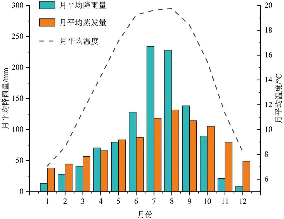
| [1] |
韩旭东. 晚更新世曲龙滑坡堵江事件分析及堵江运动特征数值模拟研究[D]. 长春: 吉林大学, 2018.
|
| [2] |
李永超. 金沙江上游苏洼龙河段早期滑坡堵江事件识别及演化研究[D]. 长春: 吉林大学, 2021.
|
| [3] |
刘传正, 吕杰堂, 童立强, 等. 雅鲁藏布江色东普沟崩滑-碎屑流堵江灾害初步研究[J]. 中国地质, 2019, 46(2): 219-234.
|
| [4] |
许强, 郑光, 李为乐, 等. 2018年10月和11月金沙江白格两次滑坡-堰塞堵江事件分析研究[J]. 工程地质学报, 2018, 26(6): 1534-1551.
|
| [5] |
邓建辉, 高云建, 余志球, 等. 堰塞金沙江上游的白格滑坡形成机制与过程分析[J]. 工程科学与技术, 2019, 51(1): 9-16.
|
| [6] |
胡卸文, 黄润秋, 施裕兵, 等. 唐家山滑坡堵江机制及堰塞坝溃坝模式分析[J]. 岩石力学与工程学报, 2009, 28(1): 181-189.
|
| [7] |
王家柱, 任光明, 葛华. 金沙江上游某特大型滑坡发育特征及堵江机制[J]. 长江科学院院报, 2019, 36(2): 46-51, 57.
|
| [8] |
高云建, 赵思远, 邓建辉. 青藏高原三江并流区重大堵江滑坡孕育规律及其防灾挑战[J]. 工程科学与技术, 2020, 52(5): 50-61.
|
| [9] |
PENG M, ZHANG L M. Breaching parameters of landslide dams[J]. Landslides, 2012, 9(1): 13-31.
|
| [10] |
FAN X M, DUFRESNE A, SIVA SUBRAMANIAN S, et al. The formation and impact of landslide dams-State of the art[J]. Earth-Science Reviews, 2020, 203: 103116.
|
| [11] |
周礼, 范宣梅, 许强, 等. 金沙江白格滑坡运动过程特征数值模拟与危险性预测研究[J]. 工程地质学报, 2019, 27(6): 1395-1404.
|
| [12] |
徐文杰, 陈祖煜, 何秉顺, 等. 肖家桥滑坡堵江机制及灾害链效应研究[J]. 岩石力学与工程学报, 2010, 29(5): 933-942.
|
| [13] |
樊晓一, 黄润秋, 乔建平, 等. 未受河流阻止的滑坡水平运动距离与滑坡堵江判别[J]. 水文地质工程地质, 2014, 41(1): 128-133.
|
| [14] |
王珊珊, 童立强, 郭兆成, 等. 基于河长: 坡降指数的滑坡堵江事件自动识别[J]. 工程地质学报, 2017, 25(2): 511-519.
|
| [15] |
陈语, 李天斌, 魏永幸, 等. 沟谷型滑坡灾害链成灾机制及堵江危险性判别方法[J]. 岩石力学与工程学报, 2016, 35(增刊2): 4073-4081.
|
| [16] |
VAN WESTEN C J, CASTELLANOS E, KURIAKOSE S L. Spatial data for landslide susceptibility, hazard, and vulnerability assessment: an overview[J]. Engineering Geology, 2008, 102(3/4): 112-131.
|
| [17] |
刘文, 王猛, 朱赛楠, 等. 基于光学遥感技术的高山极高山区高位地质灾害链式特征分析: 以金沙江上游典型堵江滑坡为例[J]. 中国地质灾害与防治学报, 2021, 32(5): 29-39.
|
| [18] |
陆会燕, 李为乐, 许强, 等. 光学遥感与InSAR结合的金沙江白格滑坡上下游滑坡隐患早期识别[J]. 武汉大学学报(信息科学版), 2019, 44(9): 1342-1354.
|
| [19] |
蔡耀军, 徐复兴, 朱萌, 等. 金沙江白格滑坡残留体失稳堵江风险分析[J]. 工程科学与技术, 2021, 53(6): 33-42.
|
| [20] |
李高, 谭建民, 王世梅, 等. 滑坡对降雨响应的多指标监测及综合预警探析: 以赣南罗坳滑坡为例[J]. 地学前缘, 2021, 28(6): 283-294.
|
| [21] |
殷志强, 魏刚, 秦小光, 等. 青藏高原东北缘黄河上游滑坡与堰塞湖研究进展[J]. 地学前缘, 2021, 28(2): 46-57.
|
| [22] |
魏云杰, 王俊豪, 胡爱国, 等. 澜沧江拉金神谷滑坡成灾机理分析[J]. 中国地质调查, 2022, 9(4): 19-26.
|
| [23] |
郭方琴. 降雨与水位升降对边坡稳定性影响分析[D]. 南昌: 南昌大学, 2018.
|
| [24] |
马茜. 降雨和水位变化对库岸边坡稳定性影响的数值模拟研究[D]. 南京: 南京大学, 2015.
|
| [25] |
温丽旺. 云南省云龙县果郎沟泥石流危险性评价研究[D]. 成都: 成都理工大学, 2018.
|
| [26] |
鹿守山. 尾矿库漫顶溃坝模型试验及数值模拟[D]. 南昌: 南昌工程学院, 2019.
|
| [27] |
费建波, 介玉新, 张丙印, 等. 颗粒流底部摩擦模型在高速远程滑坡模拟中的运用[J]. 水力发电学报, 2016, 35(1): 104-109.
|
| [28] |
SALM B. Flow, flow transition and runout distances of flowing avalanches[J]. Annals of Glaciology, 1993, 18: 221-226.
|
| [29] |
HUNGR O. A model for the runout analysis of rapid flow slides, debris flows, and avalanches[J]. Canadian Geotechnical Journal, 1995, 32(4): 610-623.
|
| [30] |
HUNGR O, MCDOUGALL S. Two numerical models for landslide dynamic analysis[J]. Computers and Geosciences, 2009, 35(5): 978-992.
|
| [31] |
DI Y, WEI Y J, TAN W J, et al. Research on development characteristics and landslide dam hazard prediction of Zhuangfang landslide in the upper reaches of the Nu river[J]. Sustainability, 2023, 15(20): 15036.
|
| [32] |
张宏蓉, 杜娟, 殷坤龙, 等. 基于DAN-3D模型的滑坡运动特性模拟研究[J]. 甘肃科学学报, 2021, 33(6): 103-108.
|
| [33] |
郑鸿超, 石振明, 彭铭, 等. 崩滑碎屑体堵江成坝研究综述与展望[J]. 工程科学与技术, 2020, 52(2): 19-28.
|
 ), 魏云杰2, 谭维佳1, 徐强1,*(