地学前缘 ›› 2024, Vol. 31 ›› Issue (6): 1-18.DOI: 10.13745/j.esf.sf.2024.10.13
王贵玲1,2( ), 蔺文静1,2,*()
收稿日期:2024-10-15
修回日期:2024-10-28
出版日期:2024-11-25
发布日期:2024-11-25
通信作者:
*蔺文静(1978—),男,研究员,博士生导师,从事地热地质相关研究工作。E-mail: linwenjing@mail.cgs.gov.cn
作者简介:王贵玲(1964—),男,研究员,博士生导师,主要从事水文地质、地热地质相关研究工作。E-mail: guilingw@163.com
基金资助:
WANG Guiling1,2(), LIN Wenjing1,2,*()
Received:2024-10-15
Revised:2024-10-28
Online:2024-11-25
Published:2024-11-25
摘要:
区域热状态代表一个地区大地热流的主要来源,解决了区域热源的基本问题,可为区域地热资源的研究提供基础背景。本文基于我国近年来开展的区域热流测量和深孔测温工作,分析了我国陆区壳幔热流比,并将我国陆区划分为壳源生热高温地热区、幔源生热中低温地热区、壳幔热源平衡低温地热区和壳幔热源平衡中高温地热区4种类型区。其中,壳源生热高温地热区位于藏南、川西、滇西,幔源生热中低温地热区主要位于松辽盆地、华北盆地、长江中下游等我国东部广大地区,壳幔热源平衡中高温地热区分布于东南沿海地区、四川盆地和云贵高原,西北广大内陆地区则属于壳幔热源平衡低温地热区。在此基础上,选择青藏高原东北部、腾冲地区、东南沿海和华北盆地等典型地热区,系统分析了区域地温场特征、热流分布、地壳热结构等盆地尺度的区域热状态和主控因素。青藏高原增厚地壳中的低速体构成了以壳源热为主的高热流异常;腾冲地区深部以局部岩浆囊形式存在的岩浆,则构成了以其为代表的近代火山区地热系统的主要控热要素;东南沿海大面积分布的高产热岩体生热构成了热流中重要的热流分量,而以华北盆地为代表的盆地基底起伏和深大断裂则控制了盆地“坳中凸”地热异常区的地温分布。最后,总结了包括壳幔架构、构造热事件、地层岩性、断裂构造等影响区域热状态的深部—浅部因素,建立了控制我国陆区区域热状态的多级要素体系,为不同地区地热资源勘查和热源条件分析提供了科学依据。
中图分类号:
王贵玲, 蔺文静. 我国陆区热状态及控热要素[J]. 地学前缘, 2024, 31(6): 1-18.
WANG Guiling, LIN Wenjing. The thermal status of China’s land areas and heat-control factors[J]. Earth Science Frontiers, 2024, 31(6): 1-18.

图1 我国陆区地热背景图 I—壳源生热高温地热区; II—幔源生热中低温地热区; III—壳幔热源平衡低温地热区; IV—壳幔热源平衡中高温地热区。
Fig.1 Geothermal equilibrium zones in China’s land area
| 类型 | 主要地热区 | qc/qm | 大地热流值q/ (mW·m-2) | 壳源热流值qc/ (mW·m-2) | 幔源热流值qm/ (mW·m-2) | 主要热储 温度/℃ | 热储分布范围 |
|---|---|---|---|---|---|---|---|
| 沉积盆地 传导型 | 松辽盆地 | 0.6~1.0 | 55~70 | 20~30 | 30~40 | 25~90 | 区内大面积分布, 有多个主要热储层 |
| 华北平原 | 0.6~1.0 | 55~85 | 15~35 | 30~50 | 25~120 | ||
| 关中平原 | 0.8~1.0 | 65~75 | 20~30 | 30~50 | 25~90 | ||
| 下辽河盆地 | 0.4~0.6 | 65~70 | 15~25 | 40~50 | 25~60 | 区内大面积分布, 热储层较单一或非 主要储层面积较小 | |
| 河淮盆地 | 0.6~1.0 | 55~60 | 15~30 | 30~50 | 40~60 | ||
| 苏北盆地 | 0.6~0.8 | 65~75 | 20~30 | 40~50 | 40~60 | ||
| 江汉盆地 | 0.6~1.0 | 50~60 | 25~35 | 20~40 | 25~90 | ||
| 隆起山地 对流型 | 辽东半岛 | 0.6~1.0 | 55~65 | 15~25 | 30~50 | 25~90 | 沿断裂呈带状分布 |
| 胶东半岛 | 0.6~0.8 | 65~75 | 15~25 | 40~60 | 25~90 | ||
| 燕山—太行山 | 0.4~1.2 | 45~65 | 15~30 | 20~40 | 25~90 |
表1 壳幔生热中低温区主要地热系统地热背景特征统计表
Table 1 Statistics on geothermal characteristics of major geothermal systems in medium- and low-temperature geothermal zones under crust-mantle heating
| 类型 | 主要地热区 | qc/qm | 大地热流值q/ (mW·m-2) | 壳源热流值qc/ (mW·m-2) | 幔源热流值qm/ (mW·m-2) | 主要热储 温度/℃ | 热储分布范围 |
|---|---|---|---|---|---|---|---|
| 沉积盆地 传导型 | 松辽盆地 | 0.6~1.0 | 55~70 | 20~30 | 30~40 | 25~90 | 区内大面积分布, 有多个主要热储层 |
| 华北平原 | 0.6~1.0 | 55~85 | 15~35 | 30~50 | 25~120 | ||
| 关中平原 | 0.8~1.0 | 65~75 | 20~30 | 30~50 | 25~90 | ||
| 下辽河盆地 | 0.4~0.6 | 65~70 | 15~25 | 40~50 | 25~60 | 区内大面积分布, 热储层较单一或非 主要储层面积较小 | |
| 河淮盆地 | 0.6~1.0 | 55~60 | 15~30 | 30~50 | 40~60 | ||
| 苏北盆地 | 0.6~0.8 | 65~75 | 20~30 | 40~50 | 40~60 | ||
| 江汉盆地 | 0.6~1.0 | 50~60 | 25~35 | 20~40 | 25~90 | ||
| 隆起山地 对流型 | 辽东半岛 | 0.6~1.0 | 55~65 | 15~25 | 30~50 | 25~90 | 沿断裂呈带状分布 |
| 胶东半岛 | 0.6~0.8 | 65~75 | 15~25 | 40~60 | 25~90 | ||
| 燕山—太行山 | 0.4~1.2 | 45~65 | 15~30 | 20~40 | 25~90 |

图2 青藏高原东北部地质简图及现有地热勘探深孔分布
Fig.2 Geologic sketch map of the northeastern Tibetan Plateau and distribution of existing deep boreholes for geothermal exploration

图3 青藏高原东北部已有深孔稳态(或近似稳态)测温曲线及地温梯度 (a) 同仁盆地DR1孔; (b) 平安地区PAR2孔。
Fig.3 Steady-state (or near-steady-state) logging and geothermal gradient curves of deep boreholes in the northeastern Tibetan Plateau. (a) Borehole DR1, Tongren Basin; (b) Borehole PAR2, Ping’an area.

图4 腾冲地区岩浆囊分布示意图(据文献[11])
Fig.4 Magma sacs in Tengchong area. Adapted from [11].

图5 腾冲地区地热气体3He/4He—4He/20Ne关系图
Fig.5 3He/4He—4He/20Ne plot for geothermal gas, Tengchong area
| 序号 | 钻孔名称 | 东经/(°) | 北纬/(°) | 钻孔 深度/m | 测温 深度/m | 主要岩性 | 热流 计算段深度/m | 地温梯度/ (℃·km-1) | 热流/ (mW·m-2) |
|---|---|---|---|---|---|---|---|---|---|
| 1 | 腾冲 | 98.483 333 | 25.033 333 | 600 | 600 | 花岗岩、玄武岩 | 0~600 | 39.2 | 118.1 |
| 2 | 地热大队 | 98.5 | 24.983 333 | 600 | 97 | 玄武岩 | 30~70 | 51.9 | 88.88 |
| 3* | TCKZ | 98.492 714 | 25.213 889 | 1 222.24 | 1 200 | 火山岩、花岗岩 | 0~1 200 | 42.2 | 109.7 |
| 4* | ZH01 | 98.607 952 | 25.241 438 | 1 980.18 | 1 900 | 花岗岩 | 0~1 140 | 40.6 | 105.6 |
表2 腾冲地区地热深孔测温一览表
Table 2 Geothermal parameters of deep geothermal boreholes in Tengchone area
| 序号 | 钻孔名称 | 东经/(°) | 北纬/(°) | 钻孔 深度/m | 测温 深度/m | 主要岩性 | 热流 计算段深度/m | 地温梯度/ (℃·km-1) | 热流/ (mW·m-2) |
|---|---|---|---|---|---|---|---|---|---|
| 1 | 腾冲 | 98.483 333 | 25.033 333 | 600 | 600 | 花岗岩、玄武岩 | 0~600 | 39.2 | 118.1 |
| 2 | 地热大队 | 98.5 | 24.983 333 | 600 | 97 | 玄武岩 | 30~70 | 51.9 | 88.88 |
| 3* | TCKZ | 98.492 714 | 25.213 889 | 1 222.24 | 1 200 | 火山岩、花岗岩 | 0~1 200 | 42.2 | 109.7 |
| 4* | ZH01 | 98.607 952 | 25.241 438 | 1 980.18 | 1 900 | 花岗岩 | 0~1 140 | 40.6 | 105.6 |

图6 腾冲地区深孔测温及地温梯度 (a) 腾冲马站科钻TCKZ孔; (b) 腾冲中和村ZH01孔。
Fig.6 Deep borehole temperature logging and geothermal gradient in Tengchong area. (a) TCKZ for scientific drilling, Mazhan area. (b) ZH01, Zhonghe village.

图7 腾冲地区地壳热结构
Fig.7 Crustal thermal structure in Tengchong area

图8 东南沿海不同地区地热气体3He/4He—4He/20Ne关系图(据文献[57]修改)
Fig.8 3He/4He—4He/20Ne plot for geothermal gas,southeastern coastal area. Modified from [57].

图9 东南沿海黄砂洞地热田热流配分示意图
Fig.9 Heat flow distribution in Huangshadong geothermal field, southeastern coastal area

图10 华北地区近年施工的部分深钻分布图
Fig.10 Distribution of some deep geothermal boreholes constructed in recent years in North China
| 钻孔编号 | 构造位置 | 经度/(°) | 纬度/(°) | 终孔深度/m | 终孔地层 | 基岩深度/m | 孔底温度/℃ | 热流/(mW·m-2) |
|---|---|---|---|---|---|---|---|---|
| GRY1-SD | 陈庄潜凸 | 118.55 | 37.67 | 2 500.58 | 新太古界泰山岩群 | 1 243 | 104.2 | 71.9 |
| GRY1-HB | 沧县隆起 | 116.18 | 38.21 | 4 025.82 | 长城系高于庄组 | 1 326.6 | 107.5 | 59.7 |
| D35 | 高阳低凸起 | 115.94 | 38.87 | 3 853 | 蓟县系雾迷山组 | 3 660 | 120.88 | 57.0 |
| M-1 | 马头营凸起 | 118.70 | 39.20 | 4 500 | 太古宇变质岩系 | 1 376 | 157 | 73.0 |
| M-5 | 马头营凸起 | 118.76 | 39.20 | 4 000 | 太古宇变质岩系 | 1 401.5 | 120.32 | 64.8 |
表3 近年来华北地区部分地热深钻详情一览表
Table 3 Geothermal parameters of selected geothermal deep boreholes, northern China
| 钻孔编号 | 构造位置 | 经度/(°) | 纬度/(°) | 终孔深度/m | 终孔地层 | 基岩深度/m | 孔底温度/℃ | 热流/(mW·m-2) |
|---|---|---|---|---|---|---|---|---|
| GRY1-SD | 陈庄潜凸 | 118.55 | 37.67 | 2 500.58 | 新太古界泰山岩群 | 1 243 | 104.2 | 71.9 |
| GRY1-HB | 沧县隆起 | 116.18 | 38.21 | 4 025.82 | 长城系高于庄组 | 1 326.6 | 107.5 | 59.7 |
| D35 | 高阳低凸起 | 115.94 | 38.87 | 3 853 | 蓟县系雾迷山组 | 3 660 | 120.88 | 57.0 |
| M-1 | 马头营凸起 | 118.70 | 39.20 | 4 500 | 太古宇变质岩系 | 1 376 | 157 | 73.0 |
| M-5 | 马头营凸起 | 118.76 | 39.20 | 4 000 | 太古宇变质岩系 | 1 401.5 | 120.32 | 64.8 |
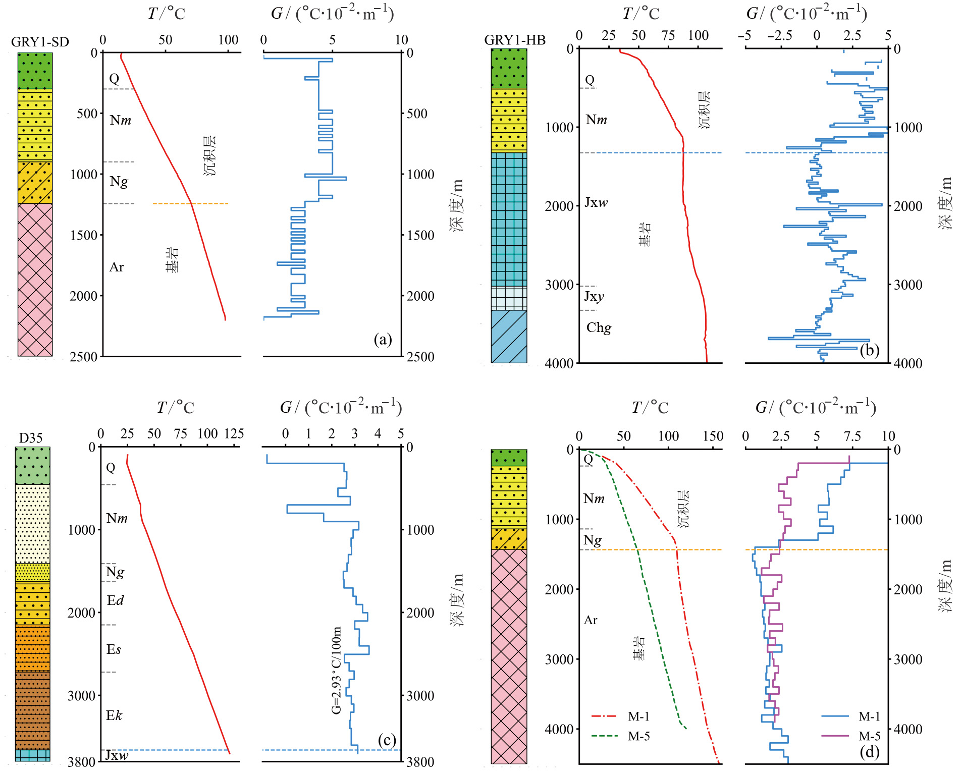
图11 华北地区深孔测温及地温梯度 a—陈庄潜凸;b—沧县隆起;c—高阳低凸起;d—马头营凸起。
Fig.11 Temperature logging and geothermal gradient curves of deep boreholes, northern China. (a) Chenzhuang uplift. (b) Cangxian uplift. (c) Gaoyang lower uplift. (d) Matouying uplift.
| 一级因素 | 二级因素 | 三级因素 | 典型地热系统 |
|---|---|---|---|
| 浅部因素 | 地层岩性 | 基底起伏 | 华北传导—对流复合地热系统 |
| 高放射性岩体分布 | 华南中低温对流型地热系统 | ||
| 断裂构造 | 盖层—基底断裂 | 广大山区对流型地热系统 | |
| 地壳—岩石圈断裂 | 郯庐断裂带地热系统 | ||
| 深部因素 | 壳幔架构 | 地壳减薄 | 华北克拉通东部 |
| 地壳增厚 | 青藏高原 | ||
| 构造热事件 | 壳内火山岩浆囊 | 腾冲地区 | |
| 壳内低速体 | 青藏高原共和盆地 |
表4 影响我国陆区区域热状态的多级因素
Table 4 Multilevel factors affecting the regional thermal state
| 一级因素 | 二级因素 | 三级因素 | 典型地热系统 |
|---|---|---|---|
| 浅部因素 | 地层岩性 | 基底起伏 | 华北传导—对流复合地热系统 |
| 高放射性岩体分布 | 华南中低温对流型地热系统 | ||
| 断裂构造 | 盖层—基底断裂 | 广大山区对流型地热系统 | |
| 地壳—岩石圈断裂 | 郯庐断裂带地热系统 | ||
| 深部因素 | 壳幔架构 | 地壳减薄 | 华北克拉通东部 |
| 地壳增厚 | 青藏高原 | ||
| 构造热事件 | 壳内火山岩浆囊 | 腾冲地区 | |
| 壳内低速体 | 青藏高原共和盆地 |
| [1] | MORGAN P. The thermal structure and thermal evolution of the continental lithosphere[J]. Physics and Chemistry of the Earth, 1984, 15: 107-193. |
| [2] | WANG J Y. Geothermics in China[M]. Beijing: Seismological Press, 1996. |
| [3] | 胡圣标, 何丽娟, 汪集旸. 中国大陆地区大地热流数据汇编(第三版)[J]. 地球物理学报, 2001, 44(5): 611-626. |
| [4] |
姜光政, 高堋, 饶松, 等. 中国大陆地区大地热流数据汇编(第四版)[J]. 地球物理学报, 2016, 59(8): 2892-2910.
DOI |
| [5] | HU S B, HE L J, WANG J Y. Heat flow in the continental area of China: a new dataset[J]. Earth and Planetary Science Letters, 2000, 179(2): 407-419. |
| [6] | 王贵玲, 刘峰, 蔺文静, 等. 我国陆区地壳生热率分布与壳幔热流特征研究[J]. 地球物理学报, 2023, 66(12): 5041-5056. |
| [7] | 王贵玲, 蔺文静, 刘峰, 等. 地热系统深部热能聚敛理论及勘查实践[J]. 地质学报, 2023, 97(3): 639-660. |
| [8] | 汪集旸, 黄少鹏. 大地热流图[M]//袁学诚. 中国地球物理图集. 北京: 地质出版社, 1996: 188. |
| [9] | 邱楠生. 中国大陆地区沉积盆地热状况剖面[J]. 地球科学进展, 1998, 13(5): 447-451. |
| [10] | 郎旭娟, 刘峰, 刘志明, 等. 青海省贵德盆地大地热流研究[J]. 地质科技情报, 2016, 35(3): 227-232. |
| [11] | 郎旭娟, 张发旺, 王贵玲. 贵德盆地热结构及地热成因机制[J]. 地球学报, 2017, 38(增刊1): 43-46. |
| [12] |
张超, 张盛生, 李胜涛, 等. 共和盆地恰卜恰地热区现今地热特征[J]. 地球物理学报, 2018, 61(11): 4545-4557.
DOI |
| [13] |
张超, 胡圣标, 宋荣彩, 等. 共和盆地干热岩地热资源的成因机制: 来自岩石放射性生热率的约束[J]. 地球物理学报, 2020, 63(7): 2697-2709.
DOI |
| [14] | LIN W J, WANG G L, ZHANG S S, et al. Heat aggregation mechanisms of hot dry rocks resources in the Gonghe Basin, northeastern Tibetan Plateau[J]. Acta Geologica Sinica (English Edition), 2021, 95(6): 1793-1804. |
| [15] | 张森琦, 许伟林, 严维德, 等. 西宁盆地地热地质[M]. 北京: 地质出版社, 2013. |
| [16] | 袁玉松, 马永生, 胡圣标, 等. 中国南方现今地热特征[J]. 地球物理学报, 2006, 49(4): 1118-1126. |
| [17] | 何丽娟, 邱楠生. 热与克拉通破坏[J]. 地质科学, 2014, 49(3): 728-738. |
| [18] | 胡圣标, 黄少鹏. 中国陆地大地热流[M]//汪集旸, 等. 地热学及其应用. 北京: 科学出版社, 2015: 64-1222. |
| [19] | 王一波, 刘绍文, 陈超强, 等. 中国陆域大地热流数据汇编(第五版)[J]. 地球物理学报, 2024, 67(11): 4233-4265. |
| [20] | KONG Y L, PAN S, REN Y Q, et al. Catalog of enhanced geothermal systems based on heat sources[J]. Acta Geologica Sinica (English Edition), 2021, 95(6): 1882-1891. |
| [21] | 邱楠生, 唐博宁, 朱传庆. 中国大陆地区温泉分布的深部热背景[J]. 地质学报, 2022, 96(1): 195-207. |
| [22] |
姜光政, 王亚奇, 胡杰, 等. 中国中—高温地热资源勘探方向与优选靶区[J]. 科技导报, 2022, 40(20): 76-82.
DOI |
| [23] |
张健, 方桂, 何雨蓓. 中国东部地热异常区深层高温分布特征与动力学背景[J]. 地学前缘, 2023, 30(2): 316-332.
DOI |
| [24] | 饶松, 黄顺德, 胡圣标, 等. 中国陆区干热岩勘探靶区优选: 来自国内外干热岩系统成因机制的启示[J]. 地球科学, 2023, 48(3): 857-877. |
| [25] | 侯增谦, 郑远川, 卢占武, 等. 青藏高原巨厚地壳: 生长、加厚与演化[J]. 地质学报, 2020, 94(10): 2797-2815. |
| [26] |
KIND R, NI J, ZHAO W J, et al. Evidence from earthquake data for a partially molten crustal layer in southern Tibet[J]. Science, 1996, 274(5293): 1692-1694.
PMID |
| [27] |
BROWN L D, ZHAO W J, NELSON K D, et al. Bright spots, structure, and magmatism in southern Tibet from INDEPTH seismic reflection profiling[J]. Science, 1996, 274(5293): 1688-1690.
PMID |
| [28] |
NELSON K D, ZHAO W J, BROWN L D, et al. Partially molten middle crust beneath southern Tibet: synthesis of project INDEPTH results[J]. Science, 1996, 274(5293): 1684-1688.
PMID |
| [29] | VERGNE J, WITTLINGER G, HUI Q, et al. Seismic evidence for stepwise thickening of the crust across the NE Tibetan Plateau[J]. Earth and Planetary Science Letters, 2002, 203(1): 25-33. |
| [30] | GAO J, ZHANG H J, ZHANG S Q, et al. Three-dimensional magnetotelluric imaging of the geothermal system beneath the Gonghe Basin, Northeast Tibetan Plateau[J]. Geothermics, 2018, 76: 15-25. |
| [31] | GAO J, ZHANG H J, ZHANG H P, et al. Three-dimensional magnetotelluric imaging of the SE Gonghe Basin: implication for the orogenic uplift in the northeastern margin of the Tibetan Plateau[J]. Tectonophysics, 2020, 789: 228525. |
| [32] | ZHAO X Y, ZENG Z F, HUAI N, et al. Geophysical responses and possible geothermal mechanism in the Gonghe Basin, China[J]. Geomechanics and Geophysics for Geo-Energy and Geo-Resources, 2020, 6(1): 17. |
| [33] | 高天扬, 丁志峰, 徐小明, 等. 利用接收函数、背景噪声频散和Rayleigh波ZH振幅比联合反演青藏高原东北缘及周边地区地壳结构[J]. 地球物理学报, 2023, 66(10): 4074-4094. |
| [34] | ZHOU W N, LI Q, ZHANG D L, et al. Crustal structure and geothermal mechanism of the Gonghe-guide Basin based on EIGEN-6C4 satellite gravity and aeromagnetic data[J]. Pure and Applied Geophysics, 2023, 180(7): 2735-2756. |
| [35] | 李永华, 吴庆举, 田小波, 等. 用接收函数方法研究云南及其邻区地壳上地幔结构[J]. 地球物理学报, 2009, 52(1): 67-80. |
| [36] | 吴腾飞. 青藏高原东南部地壳上地幔结构及动力学解释[D]. 武汉: 武汉大学, 2018. |
| [37] | 张智奇. 青藏高原东南缘地壳上地幔速度结构与变形特征研究[D]. 合肥: 中国科学技术大学, 2022. |
| [38] | LEI J S, XIE F R, FAN Q C, et al. Seismic imaging of the deep structure under the Chinese volcanoes: an overview[J]. Physics of the Earth and Planetary Interiors, 2013, 224: 104-123. |
| [39] | LI C, VAN DER HILST R D, MELTZER A S, et al. Subduction of the Indian lithosphere beneath the Tibetan Plateau and Burma[J]. Earth and Planetary Science Letters, 2008, 274(1/2): 157-168. |
| [40] | MOLNAR P, STOCK J M. Slowing of India’s convergence with Eurasia since 20 Ma and its implications for Tibetan mantle dynamics[J]. Tectonics, 2009, 28(3): 2008TC002271. |
| [41] | LI S H, ADVOKAAT E L, VAN HINSBERGEN D J J, et al. Paleomagnetic constraints on the Mesozoic-Cenozoic paleolatitudinal and rotational history of Indochina and South China: review and updated kinematic reconstruction[J]. Earth-Science Reviews, 2017, 171: 58-77. |
| [42] | TONG Y B, YANG Z Y, JING X Q, et al. New insights into the Cenozoic lateral extrusion of crustal blocks on the southeastern edge of Tibetan Plateau: evidence from paleomagnetic results from Paleogene sedimentary strata of the Baoshan terrane[J]. Tectonics, 2016, 35(11): 2494-2514. |
| [43] | 王洋, 王岳军, 张培震, 等. 青藏高原东南缘断裂体系新生代构造演化[J]. 中国科学: 地球科学, 2022, 52(5): 777-802. |
| [44] | 陈墨香, 汪集旸, 邓孝. 中国地热系统类型图及其简要说明[J]. 地质科学, 1996, 31(2): 114-121. |
| [45] | 赵慈平, 冉华, 陈坤华. 腾冲火山区壳内岩浆囊现今温度: 来自温泉逸出气体CO2、CH4间碳同位素分馏的估计[J]. 岩石学报, 2011, 27(10): 2883-2897. |
| [46] | 赵慈平, 冉华, 王云. 腾冲火山区的现代幔源氦释放: 构造和岩浆活动意义[J]. 岩石学报, 2012, 28(4): 1189-1204. |
| [47] | 吴乾蕃, 祖金华, 谢毅真, 等. 云南地区地热基本特征[J]. 地震地质, 1988, 10(4): 177-183. |
| [48] | 汪缉安, 徐青, 张文仁. 云南大地热流及地热地质问题[J]. 地震地质, 1990, 12(4): 367-377. |
| [49] | 周真恒, 向才英, 邓万明. 云南岩石圈热结构[J]. 中国地震, 1997, 13(3): 19-21, 23, 25-28. |
| [50] | 汪集旸, 熊亮萍, 庞忠和. 中低温对流型地热系统[M]. 北京: 科学出版社, 1993: 6-10. |
| [51] | 胡圣标, 汪集旸. 中国东南地区地壳生热率与地幔热流[J]. 中国科学B辑: 化学生命科学地学, 1994, 24(2): 185-193. |
| [52] | 赵平, 汪集, 汪缉安, 等. 中国东南地区岩石生热率分布特征[J]. 岩石学报, 1995, 11(3): 292-305. |
| [53] | 何丽娟, 胡圣标, 汪集旸. 中国东部大陆地区岩石圈热结构特征[J]. 自然科学进展, 2001, 11(9): 966-969. |
| [54] |
张健, 王蓓羽, 唐显春, 等. 华南陆缘高热流区的壳幔温度结构与动力学背景[J]. 地球物理学报, 2018, 61(10): 3917-3932.
DOI |
| [55] | 林乐夫, 孙占学, 王安东, 等. 南岭地区与东南沿海地区中生代花岗岩放射性地球化学特征及岩石圈热结构对比研究[J]. 岩石矿物学杂志, 2017, 36(4): 488-500. |
| [56] | 蔺文静, 王贵玲, 甘浩男. 华南陆缘火成岩区差异性地壳热结构及地热意义[J]. 地质学报, 2024, 98(2): 544-557. |
| [57] | TIAN J, LI Y M, ZHOU X C, et al. Geochemical characteristics of hydrothermal volatiles from Southeast China and their implications on the tectonic structure controlling heat convection[J]. Frontiers in Earth Science, 2021, 9: 786051. |
| [58] | LIN W J, WANG G L, GAN H N, et al. Heat generation and accumulation for hot dry rock resources in the igneous rock distribution areas of Southeastern China[J]. Lithosphere, 2022, 2021(Special 5): 2039112. |
| [59] | LIN W J, WANG G L, GAN H N, et al. Heat source model for Enhanced Geothermal Systems (EGS) under different geological conditions in China[J]. Gondwana Research, 2023, 122: 243-259. |
| [60] | 甘浩男, 蔺文静, 王贵玲, 等. 广东惠州黄沙洞地区岩石圈热—流变结构及其热源启示[J]. 水文地质工程地质, 2023, 50(4): 26-38. |
| [61] | 陈墨香. 华北地热[M]. 北京: 科学出版社, 1988. |
| [62] | 阎敦实, 于英太. 京津冀油区地热资源评价与利用[M]. 武汉: 中国地质大学出版社, 2000. |
| [63] | 龚育龄. 中国东部渤海湾盆地热结构和热演化[M]. 北京: 中国原子能出版社, 2011. |
| [64] | 王贵玲, 张薇, 蔺文静, 等. 京津冀地区地热资源成藏模式与潜力研究[J]. 中国地质, 2017, 44(6): 1074-1085. |
| [65] | 王贵玲, 蔺文静. 我国主要水热型地热系统形成机制与成因模式[J]. 地质学报, 2020, 94(7): 1923-1937. |
| [66] | 熊亮萍, 张菊明. 华北平原区地温梯度与基底构造形态的关系[J]. 地球物理学报, 1988, 31(2): 146-155. |
| [67] | 毛小平, 汪新伟, 李克文, 等. 地热田热量来源及形成主控因素[J]. 地球科学, 2018, 43(11): 4256-4266. |
| [68] |
王朱亭, 张超, 姜光政, 等. 雄安新区现今地温场特征及成因机制[J]. 地球物理学报, 2019, 62(11): 4313-4322.
DOI |
| [69] | 龚育龄, 王良书, 刘绍文, 等. 济阳坳陷大地热流分布特征[J]. 中国科学D辑: 地球科学, 2003, 33(4): 384-391. |
| [70] | ORD A, OLIVER N H S. Mechanical controls on fluid flow during regional metamorphism: some numerical models[J]. Journal of Metamorphic Geology, 1997, 15(3): 345-359. |
| [71] | BELLANI S, BROGI A, LAZZAROTTO A, et al. Heat flow, deep temperatures and extensional structures in the larderello geothermal field (Italy): constraints on geothermal fluid flow[J]. Journal of Volcanology and Geothermal Research, 2004, 132(1): 15-29. |
| [72] | DUWIQUET H, GUILOU-FROTTIER L, ARBARET L, et al. Crustal Fault Zones as underexploited geothermal resources: contribution of numerical modelling and comparison with natural systems[C]// PROCEEDINGS, 47th Workshop on Geothermal Reservoir Engineering Stanford University, Stanford, California, February 7-9, 2022: SGP-TR-223. |
| [73] | 石鸿蕾, 王婉丽, 王贵玲, 等. 典型高温地热系统水热循环及锂同位素分馏过程模拟研究[J]. 地学前缘, 2024, 31(6): 104-119. |
| [74] | MASE C W, SMITH L, 王永才. 流体孔隙压和断层面的摩擦生热[J]. 华北地震科学, 1986, 4(增刊1): 119-133. |
| [75] | PAN S, KONG Y L, WANG K, et al. Magmatic origin of geothermal fluids constrained by geochemical evidence: implications for the heat source in the northeastern Tibetan Plateau[J]. Journal of Hydrology, 2021, 603: 126985. |
| [76] | 廖志杰. 福建无岩浆热源的深循环水热系统[J]. 现代地质, 2012, 26(1): 85-98. |
| [1] | 刘峰, 王贵玲, 姜光政, 胡圣标, 张薇, 蔺文静, 刘金辉, 张心勇, 屈泽伟, 廖传志. 我国陆区大地热流测量新进展与新认识[J]. 地学前缘, 2024, 31(6): 19-30. |
| [2] | 康志强, 张起钻, 管彦武, 刘德民, 袁金福, 杨志强, 陆济璞, 王新宇, 张勤军, 张美玲, 冯民豪. 广西干热岩地热资源赋存条件分析[J]. 地学前缘, 2020, 27(1): 55-62. |
| [3] | 李宗星, 高俊, 李文飞, 吴剑锋. 柴达木盆地地温场分布特征及控制因素[J]. 地学前缘, 2016, 23(5): 23-32. |
| 阅读次数 | ||||||
|
全文 |
|
|||||
|
摘要 |
|
|||||