地学前缘 ›› 2022, Vol. 29 ›› Issue (5): 216-228.DOI: 10.13745/j.esf.sf.2021.9.15
孙志文1,2( ), 贾永刚1,2,*(), 权永峥1,2,*(), 郭秀军1,2, 刘涛1,2, 孟庆生1,2, 孙中强1,2, 李凯1,2, 范智涵1,2, 陈天1,2, 唐浩儒1,2
收稿日期:2020-07-26
修回日期:2020-11-10
出版日期:2022-09-25
发布日期:2022-08-24
通信作者:
贾永刚,权永峥
作者简介:孙志文(1991—),男,博士,主要从事海洋工程地质原位观测研究工作。E-mail: zhiwensun91@163.com
基金资助:
SUN Zhiwen1,2(), JIA Yonggang1,2,*(), QUAN Yongzheng1,2,*(), GUO Xiujun1,2, LIU Tao1,2, MENG Qingsheng1,2, SUN Zhongqiang1,2, LI Kai1,2, FAN Zhihan1,2, CHEN Tian1,2, TANG Haoru1,2
Received:2020-07-26
Revised:2020-11-10
Online:2022-09-25
Published:2022-08-24
Contact:
JIA Yonggang,QUAN Yongzheng
摘要:
海底滑坡、浊流等深海底地质灾害严重威胁海洋工程安全,是国家深海开发亟待解决的风险问题。为避免深海海底地质灾害对海底工程造成危害,解决深海海底地质灾害监测预警的难题,我们研发了一套复杂深海工程地质原位长期监测系统。该系统通过声学、电阻率、超孔隙水压力等方法监测深海海底沉积物的物理力学性质变化,实现了对深海海底地质灾害的监测和预警。该系统主要包括海床基搭载平台、监测系统、通信控制系统、供电系统等。其中监测系统主要通过原位长期监测海底沉积物的电阻率、声学、超孔隙水压力等的变化来获取海底沉积物的物理力学性质变化;通信控制系统可以实现海底到海面,再到陆地的双向通信和数据传输。其中供电系统通过独特设计的海水电池工艺,可以满足该系统在海底长期工作一年的电量需求。复杂深海工程地质原位长期监测系统已完成了近海测试,并搭载“海洋地质六号”“东方红三号” “张謇号”等科考船在南海进行了多次远海海试,获取了丰富的实测数据。电阻率监测系统采用温纳法滚动测量,测得的水土界面位置平均电阻率为0.207 Ω·m。超孔隙水压力监测系统采用开放式结构的压差式光纤光栅孔压测量方法,监测到孔压观测的4个标志性阶段:(1)贯入过程引起的超孔隙水压力累计,峰值为34.942 kPa,历时0.182 h;(2)贯入完成后累积的超孔隙水压力衰减,衰减到9.973 kPa,历时为0.810 h;(3)环境应力引起的超孔隙水压力实时响应,超孔隙水压力的变化范围为8.327~14.384 kPa;(4)残余孔隙水压力平均值为11.150 kPa。声学监测系统采用两个一发三收模式,测量的海水平均声速为1 533 m/s,测量的海底沉积物自上而下的平均声速依次为1 586、1 587、1 784、1 735、1 831 m/s。复杂深海工程地质原位长期监测系统的成功研制将显著提升目前海洋工程地质原位长期观测的技术能力,解决复杂深海工程地质评价及地质灾害监测预警的技术难题。
中图分类号:
孙志文, 贾永刚, 权永峥, 郭秀军, 刘涛, 孟庆生, 孙中强, 李凯, 范智涵, 陈天, 唐浩儒. 复杂深海工程地质原位长期监测系统研发与应用[J]. 地学前缘, 2022, 29(5): 216-228.
SUN Zhiwen, JIA Yonggang, QUAN Yongzheng, GUO Xiujun, LIU Tao, MENG Qingsheng, SUN Zhongqiang, LI Kai, FAN Zhihan, CHEN Tian, TANG Haoru. Development and application of long-term in situ monitoring system for complex deep-sea engineering geology[J]. Earth Science Frontiers, 2022, 29(5): 216-228.

图1 复杂深海工程地质原位长期监测系统工作模式图
Fig.1 The working pattern diagram of the in-situ Surveying Equipment of Engineering Geology (SEEGeo) in complex deep sea

图2 SEEGeo监测平台实物图
Fig.2 The photograph of SEEGeo
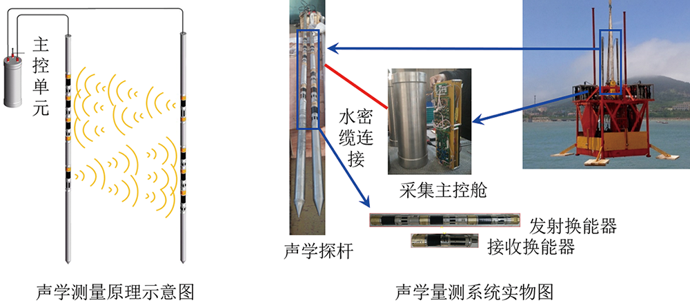
图3 声学监测系统示意图与实物图
Fig.3 Schematic diagram and photograph of acoustic monitoring system

图4 电阻率监测系统示意图与实物图
Fig.4 Schematic diagram and photograph of resistivity monitoring system
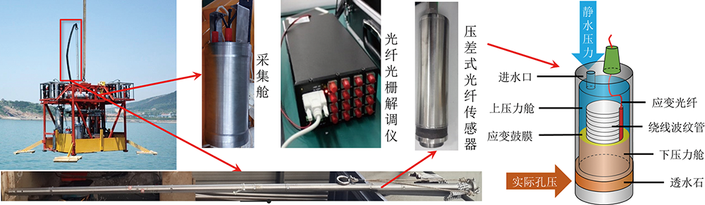
图5 超孔隙水压力监测系统
Fig.5 The pore pressure monitoring system
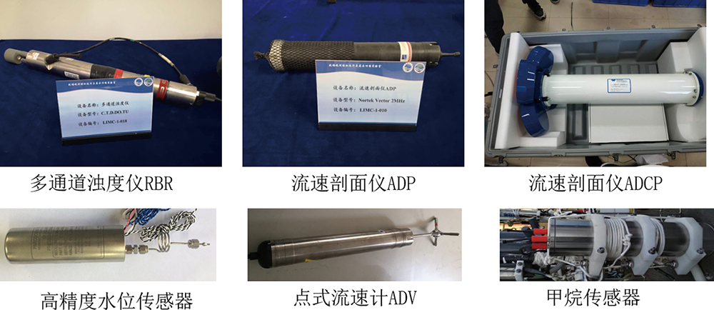
图6 海洋水动力长期监测系统组成
Fig.6 Marine hydrodynamic long-term monitoring system

图7 海-空-地一体化数据实时通信系统
Fig.7 Integrated sea-air-land data real-time communication system
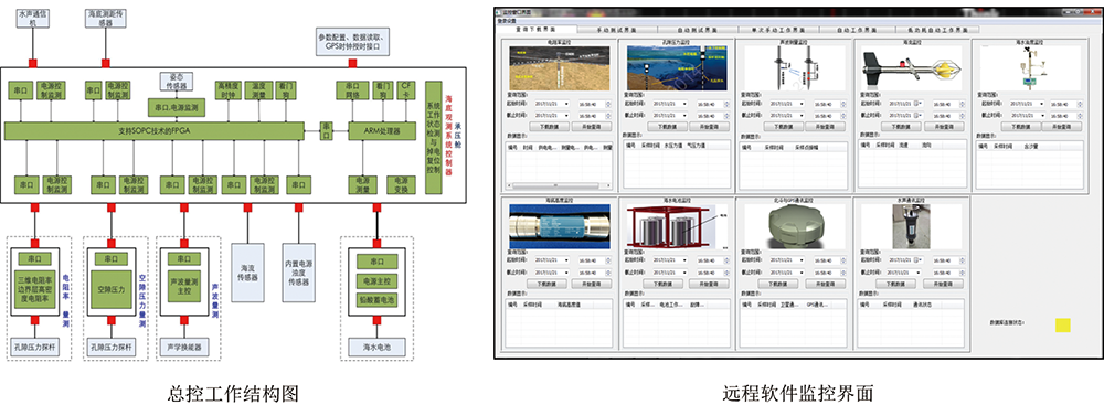
图8 总控系统控制结构和远程控制软件
Fig.8 The control structure and remote control software of the main control system

图9 海水电池原理图和实物图
Fig.9 The schematic diagram and photograph of seawater battery
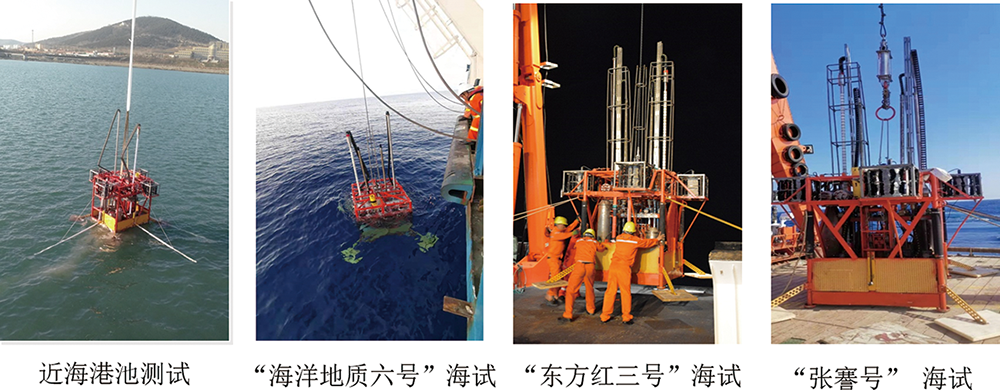
图10 SEEGeo近海海试和多次南海深海海试
Fig.10 The offshore sea trial and the South China Sea trial of SEEGeo
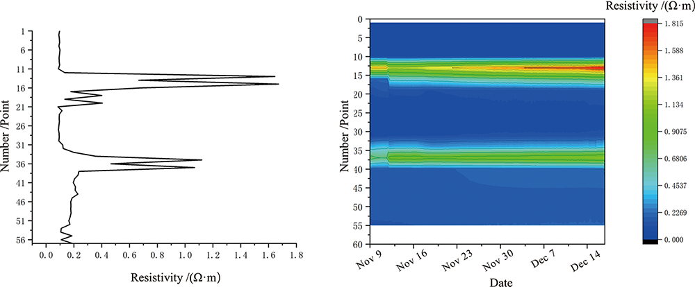
图11 单次电阻率监测数据和多次电阻率数据监测云图
Fig.11 Single resistivity monitoring data and multiple resistivity data monitoring cloud
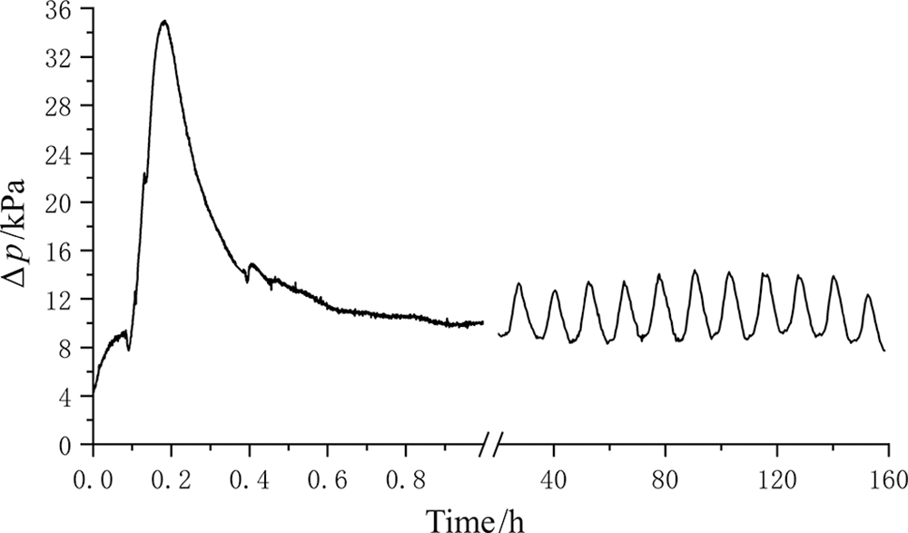
图12 海底沉积物超孔隙水压力长期监测曲线
Fig.12 Long-term monitoring curve of excess pore water pressure in seafloor sediments
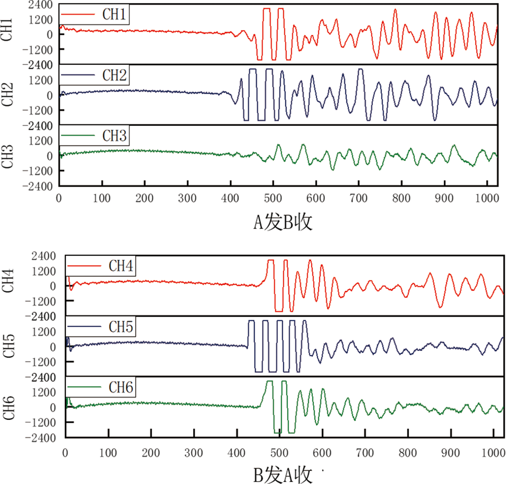
图13 海底沉积物六通道声学波形图
Fig.13 The six channel acoustic wave data of seabed sediments
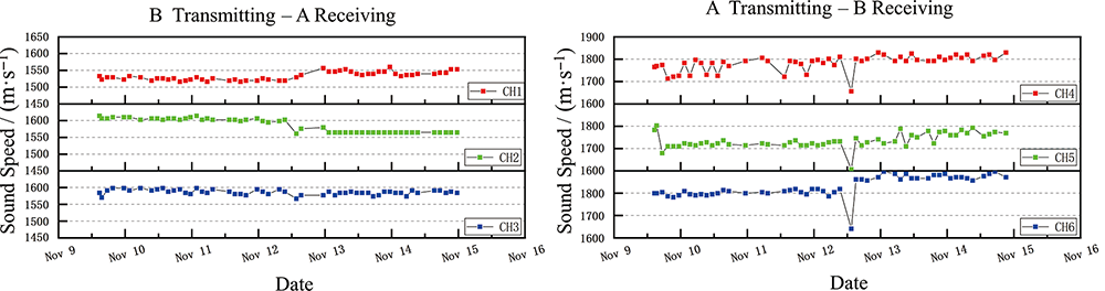
图14 海底沉积物六通道声速图
Fig.14 Six channel sound velocity of seabed sediment
| 接收通道 | 声速/(m·s-1) | 方差值 | ||
|---|---|---|---|---|
| 最小值 | 最大值 | 平均值 | ||
| CH1 | 1 516 | 1 560 | 1 533 | 145 |
| CH2 | 1 561 | 1 614 | 1 586 | 404 |
| CH3 | 1 567 | 1 598 | 1 587 | 51 |
| CH4 | 1 656 | 1 830 | 1 784 | 1 253 |
| CH5 | 1 607 | 1 803 | 1 735 | 1 052 |
| CH6 | 1 641 | 1 897 | 1 831 | 2 108 |
表1 海底沉积物六通道声速汇总表
Table 1 Summary of six channel sound velocity of seafloor sediments
| 接收通道 | 声速/(m·s-1) | 方差值 | ||
|---|---|---|---|---|
| 最小值 | 最大值 | 平均值 | ||
| CH1 | 1 516 | 1 560 | 1 533 | 145 |
| CH2 | 1 561 | 1 614 | 1 586 | 404 |
| CH3 | 1 567 | 1 598 | 1 587 | 51 |
| CH4 | 1 656 | 1 830 | 1 784 | 1 253 |
| CH5 | 1 607 | 1 803 | 1 735 | 1 052 |
| CH6 | 1 641 | 1 897 | 1 831 | 2 108 |
| [1] |
RUPPEL C D, KESSLER J D. The interaction of climate change and methane hydrates[J]. Reviews of Geophysics, 2017, 55(1): 126-168.
DOI URL |
| [2] |
BOSWELL R, COLLETT T S. Current perspectives on gas hydrate resources[J]. Energy and Environmental Science, 2011, 4(4): 1206-1215.
DOI URL |
| [3] |
CACCHIONE D A, DRAKE D E. A new instrument system to investigate sediment dynamics on continental shelves[J]. Marine Geology, 1979, 30(3/4): 299-312.
DOI URL |
| [4] | KOPP H, LANGE D, HANNEMANN K, et al. RV SONNE Fahrtbericht/Cruise Report SO244/2, GeoSEA: geodetic earthquake observatory on the seafloor, Antofagasta (Chile)-Antofagasta (Chile), 27.11.-13.12.2015[R/OL]. [2020-11-17]. Kiel: GEOMAR Helmholtz Centre for Ocean Research, 2016: 1-86. https://oceanrep.geomar.de/34821/ |
| [5] |
CHEE S, LEOKPRASIRTKUL T, KANNO T, et al. A deepwater sandface monitoring system for offshore gas hydrate[C/OL]. Offshore Technology Conference, Houston, Texas, USA, 2014[2014-05-05]. https://doi.org/10.4043/25328-MS. 10.4043/25328-MS.
DOI URL |
| [6] |
KONNO Y, FUJII T, SATO A, et al. Key findings of the world's first offshore methane hydrate production test off the coast of Japan: toward future commercial production[J]. Energy and Fuels, 2017, 31(3): 2607-2616.
DOI URL |
| [7] |
YAMAMOTO K, KANNO T, WANG X X, et al. Thermal responses of a gas hydrate-bearing sediment to a depressurization operation[J]. RSC Advances, 2017, 7(10): 5554-5577.
DOI URL |
| [8] |
YAMAMOTO K, WANG X X, TAMAKI M, et al. The second offshore production of methane hydrate in the Nankai Trough and gas production behavior from a heterogeneous methane hydrate reservoir[J]. RSC Advances, 2019, 9(45): 25987-26013.
DOI URL |
| [9] |
LI J F, YE J L, QIN X W, et al. The first offshore natural gas hydrate production test in South China Sea[J]. China Geology, 2018, 1(1): 5-16.
DOI URL |
| [10] |
YE J L, QIN X W, QIU H J, et al. Preliminary results of environmental monitoring of the natural gas hydrate production test in the South China Sea[J]. China Geology, 2018, 1(2): 202-209.
DOI URL |
| [11] |
YE J L, QIN X W, XIE W W, et al. The second natural gas hydrate production test in the South China Sea[J]. China Geology, 2020, 3(2): 197-209.
DOI URL |
| [12] | 侯正瑜, 郭常升, 王景强, 等. 利用Gassmann方程预测海底沉积物孔隙度[J]. 地球科学, 2016, 41(7): 1198-1205. |
| [13] |
BUCKINGHAM M J. Compressional and shear wave properties of marine sediments: comparisons between theory and data[J]. The Journal of the Acoustical Society of America, 2005, 117(1): 137-152.
DOI URL |
| [14] |
JACKSON D R, RICHARDSON M D, ISAKSON M J, et al. High-frequency seafloor acoustics[J]. The Journal of the Acoustical Society of America, 2008, 122(5): 2497.
DOI URL |
| [15] | KAN G M, CAO G L, WANG J Q, et al. Shear wave speed of shallow seafloor sediments in the northern South China Sea and their correlations with physical parameters[J]. Earth and Space Science, 2020, 7(3): e2019EA000950. |
| [16] | 郭秀军, 刘涛, 贾永刚, 等. 土的工程力学性质与其电阻率关系实验研究[J]. 地球物理学进展, 2003, 18(1): 151-155. |
| [17] | 王秀娟, 吴时国, 刘学伟, 等. 基于电阻率测井的天然气水合物饱和度估算及估算精度分析[J]. 现代地质, 2010, 24(5): 993-999. |
| [18] |
ARCHIE G E. The electrical resistivity log as an aid in determining some reservoir characteristics[J]. Transactions of the AIME, 1942, 146(1): 54-62.
DOI URL |
| [19] |
CAI J C, WEI W, HU X Y, et al. Electrical conductivity models in saturated porous media: a review[J]. Earth-Science Reviews, 2017, 171: 419-433.
DOI URL |
| [20] |
SCHULTHEISS P J. Pore pressures in marine sediments: an overview of measurement techniques and some geological and engineering applications[J]. Marine Geophysical Researches, 1990, 12(1/2): 153-168.
DOI URL |
| [21] |
BENNETT R H, LI H, BURNS J T, et al. Application of piezometer probes to determine engineering properties and geological processes in marine sediments[J]. Applied Clay Science, 1989, 4(4): 337-355.
DOI URL |
| [22] |
SCHULTHEISS P J, MCPHAIL S D. Direct indication of pore-water advection from pore pressure measurements in madeira abyssal plain sediments[J]. Nature, 1986, 320(6060): 348-350.
DOI URL |
| [23] | SULTAN N, RIBOULOT V, KER S, et al. Dynamics of fault-fluid-hydrate system around a shale-cored anticline in deepwater nigeria[J/OL]. Journal of Geophysical Research: Solid Earth, 2011, 116(B12)[2021-03-23]. https://agupubs.onlinelibrary.wiley.com/doi/abs/10.1029/2011JB008218 |
| [24] | 刘涛, 柴万里, 郭磊. 基于FBG的深海沉积物孔压观测设备研究[J]. 中国海洋大学学报(自然科学版), 2017, 47(10): 126-133. |
| [25] | 高峰, 朱川林, 李昊, 等. 海口湾海洋水动力自然灾害评估分析[J]. 中国海洋大学学报(自然科学版), 2019, 49(9): 130-138. |
| [26] | 常永国, 张飞, 郭永刚, 等. 南海深海海底观测网试验系统海底动力观测数据集[J]. 中国科学数据, 2019, 4(4): 48-55. |
| [27] | 芦永红, 丁飞, 贾永刚, 等. 从原理及特点出发探讨海水电池的应用前景[J]. 电源技术, 2020, 44(11): 1697-1700. |
| [28] |
陈玉凤, 李栋梁, 梁德青, 等. 南海沉积物天然气水合物饱和度与电阻率的关系[J]. 石油学报, 2013, 34(3): 507-512.
DOI |
| [29] | 李冬, 叶银灿, 陈培雄, 等. 宁波外海陆架沉积物电阻率特性研究[J]. 工程勘察, 2010, 38(5): 19-22. |
| [30] |
ZAINAL ABIDIN M H, SAAD R, WIJEYESEKERA D, et al. The influences of basic physical properties of clayey silt and silty sand on its laboratory electrical resistivity value in loose and dense conditions[J]. Sains Malaysiana, 2017, 46(10): 1959-1969.
DOI URL |
| [31] | BERNABÉ Y, LI M, MAINEULT A. Permeability and pore connectivity: a new model based on network simulations[J/OL]. Journal of Geophysical Research: Solid Earth, 2010, 115(B10)[2021-03-29]. https://agupubs.onlinelibrary.wiley.com/doi/abs/10.1029/2010JB007444 |
| [32] |
BIELLA G, LOZEJ A, TABACCO I. Experimental study of some hydrogeophysical properties of unconsolidated porous media[J]. Groundwater, 1983, 21(6): 741-751.
DOI URL |
| [33] |
KAMEL M H. An approach for estimating formation factor parameter from transit time data in clean sand formation[J]. Journal of Petroleum Science and Engineering, 2001, 30(2): 83-89.
DOI URL |
| [34] |
SIDDIQUI F I, OSMAN S B A B S. Simple and multiple regression models for relationship between electrical resistivity and various soil properties for soil characterization[J]. Environmental Earth Sciences, 2013, 70(1): 259-267.
DOI URL |
| [35] |
ALLÈGRE V, BRODSKY E E, XUE L, et al. Using earth-tide induced water pressure changes to measure in situ permeability: a comparison with long-term pumping tests[J]. Water Resources Research, 2016, 52(4): 3113-3126.
DOI URL |
| [36] |
BENNETT R H. Pore-water pressure measurements: Mississippi delta submarine sediments[J]. Marine Geotechnology, 1977, 2(1/2/3/4): 177-189.
DOI URL |
| [37] | HURLEY M T, SCHULTHEISS P J. Sea-bed shear moduli from measurements of tidally induced pore pressures[M/OL]// HOVEMJ M, RICHARDSONM D, STOLLR D. Shear waves in marine sediments. Dordrecht: Springer, 1991: 411-418[2021-03-22]. https://doi.org/10.1007/978-94-011-3568-9_47 |
| [38] | LONG H. Interpreting pore pressure in marine mudstones with pore pressure penetrometers, in situ data, and laboratory measurements[D/OL]. State College: The Pennsylvania State University, 2007[2007-08-03]. http://www.pqdtcn.com/thesisDetails/7D3F3E7120718FCDBA89915B8EFE7EC4 |
| [39] |
STEGMANN S, SULTAN N, KOPF A, et al. Hydrogeology and its effect on slope stability along the coastal aquifer of Nice, France[J]. Marine Geology, 2011, 280(1/2/3/4): 168-181.
DOI URL |
| [40] |
URGELES R, CANALS M, ROBERTS J, et al. Fluid flow from pore pressure measurements off La Palma, Canary Islands[J]. Journal of Volcanology and Geothermal Research, 2000, 101(3/4): 253-271.
DOI URL |
| [41] | XU W, GERMANOVICH L N. Excess pore pressure resulting from methane hydrate dissociation in marine sediments: a theoretical approach[J/OL]. Journal of Geophysical Research: Solid Earth, 2006, 111(B1)[2020-02-09]. https://agupubs.onlinelibrary.wiley.com/doi/epdf/10.1029/2004JB003600 |
| [42] | 张炜, 李新仲, 李清平, 等. 天然气水合物分解超孔隙压力研究[J]. 西南石油大学学报 (自然科学版), 2015, 37(4):107-116. |
| [43] |
LI G B, WANG J Q, LIU B H, et al. In situ acoustic properties of fine-grained sediments on the northern continental slope of the South China Sea[J]. Ocean Engineering, 2020, 218: 108244.
DOI URL |
| [1] | 徐哈宁, 邓居智, 肖慧. 基于邻近域特征的堆积层滑坡多维地电信息成像监测技术研究[J]. 地学前缘, 2023, 30(6): 473-484. |
| [2] | 季春生, 贾永刚, 朱俊江, 胡乃利, 范智涵, 胡聪, 冯学志, 余和雨, 刘博. 深海海底边界层原位观测系统研发与应用[J]. 地学前缘, 2022, 29(5): 265-274. |
| [3] | 陈天, 贾永刚, 刘涛, 刘晓磊, 单红仙, 孙中强. 海底沉积物孔隙压力原位长期观测技术回顾和展望[J]. 地学前缘, 2022, 29(5): 229-245. |
| [4] | 张振宇, 许伟伟, 邓亚平, 任静华, 施小清, 吴吉春. 三氯乙烯污染土壤的复电阻率特征和频谱参数研究[J]. 地学前缘, 2021, 28(5): 114-124. |
| [5] | 郭依群,杨胜雄,梁金强,陆敬安,林霖,匡增桂. 南海北部神狐海域高饱和度天然气水合物分布特征[J]. 地学前缘, 2017, 24(4): 24-31. |
| 阅读次数 | ||||||
|
全文 |
|
|||||
|
摘要 |
|
|||||