地学前缘 ›› 2022, Vol. 29 ›› Issue (2): 317-326.DOI: 10.13745/j.esf.sf.2021.10.38
田飞1( ), 王永1,*(), 袁路朋1, 汤文坤2
收稿日期:2021-06-15
修回日期:2021-09-23
出版日期:2022-03-25
发布日期:2022-03-31
通信作者:
王永
作者简介:田 飞(1985—),女,助理研究员,主要从事晚第四纪古气候重建、古气候指标的现代过程研究。E-mail: tianfei@cags.ac.cn
基金资助:
TIAN Fei1(), WANG Yong1,*(), YUAN Lupeng1, TANG Wenkun2
Received:2021-06-15
Revised:2021-09-23
Online:2022-03-25
Published:2022-03-31
Contact:
WANG Yong
摘要:
本文选择浑善达克沙地南缘濒临干涸的碱湖为研究对象,综合分析湖泊及流域表层沉积物的粒度、总有机碳(TOC)及其同位素(δ13CTOC)指标的空间分布特征及环境指示意义。结果表明,湖泊水域区及滩地区的黏土与粉砂组分含量高,TOC含量多低于1%,而东缘的盐生草甸砂组增加,同时TOC含量升高至10.75%;δ13CTOC值表现为从西向东,即水域区(-24.88‰)、滩地区(-25.17‰)、盐生草甸(-27.93‰)呈逐渐偏负的趋势。水域区表层沉积物粒度端员组分分析表明,粗粒端员(近源风成组分及洪积组分)含量的增加指示湖泊退缩及流域植被退化;水域区低TOC指示水生植物基本消失,陆源C3植物成为湖泊沉积物有机质的主要来源,控制了δ13CTOC的波动。当湖泊彻底干涸,裸露滩地的粒度初始以细粒组分(黏土、粉砂)为主,而后强烈的风蚀作用将富盐细粒带走,沉积物的粒度变粗,盐度降低,盐生植被入侵。此后沉积物的TOC含量显著增加,而δ13CTOC值逐渐偏负可能与上覆盐生植被演替过程中C3植物生物量增加有关。因此,乌日图音淖尔现代沉积过程及机理的研究,加深了对浑善达克沙地碱湖干涸过程中沉积及生态演化过程的认识,也为古环境的重建提供了重要依据。
中图分类号:
田飞, 王永, 袁路朋, 汤文坤. 浑善达克沙地碱湖表层沉积物的粒度、沉积有机质变化特征与指示意义[J]. 地学前缘, 2022, 29(2): 317-326.
TIAN Fei, WANG Yong, YUAN Lupeng, TANG Wenkun. Surface sediments of an alkaline lake in the Otindag sandy land: Grain size and sedimentary organic matter variations and their environmental significance[J]. Earth Science Frontiers, 2022, 29(2): 317-326.

图1 乌日图音淖尔地理概况 a—乌日图音淖尔区位图;b—乌日图音淖尔遥感图(来自GF-1影像);c—正蓝旗月降水和月均温统计图(1981—2010年)(http://data.cma.cn)。
Fig.1 Geographical settings of Qrdin Nuur. (a) Regional map of Qrdin Nuur within the Otindag sandy land. (b) Remote sensing image of Qrdin Nuur (GF-1 satellite imagery).(c) Variations of average monthly precipitation and temperature in Zhenglan Qi during 1981—2010. [Source: http://data.cma.cn]

图2 乌日图音淖尔及流域表层沉积物粒度空间分布 a—均值粒径/μm;b—黏土组分/%;c—粉砂组分/%;d—砂组分/%。
Fig.2 Spatial distributions of surface sediment grain sizes (a) and fractions (b-d) in Qrdin Nuur and its catchment
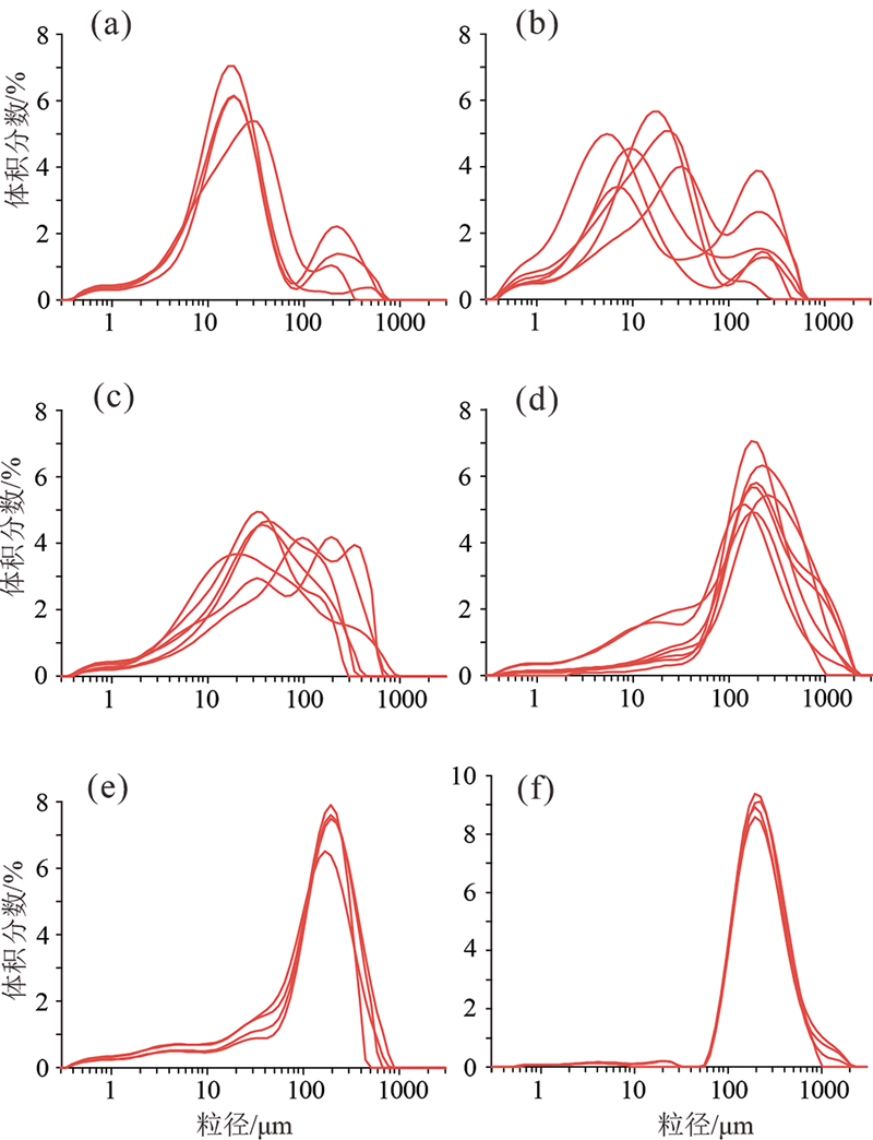
图3 乌日图音淖尔及流域表层沉积物典型粒度频率分布曲线 a—水域区;b—滩地区;c—盐生草甸区;d—洪积区;e—荒漠草原区;f—周边沙丘。
Fig.3 Typical grain-size frequency distribution curves for surface sediments of different terrains in Qrdin Nuur and its catchment

图4 乌日图音淖尔湖泊表层沉积物粒度端员组分分析
Fig.4 Results of end member mixing analysis of surface sediments of Qrdin Nuur

图5 乌日图音淖尔及流域表层沉积物空间分布 a—TOC/%;b—δ13CTOC/‰。
Fig.5 Spatial distribution of surface sediment organic matter in Qrdin Nuur and its catchment

图6 乌日图音淖尔干涸过程中植被演替模式图
Fig.6 Vegetation succession following lake desiccation in Qrdin Nuur
| [1] |
XIAO J L, SI B, ZHAI D Y, et al. Hydrology of Dali Lake in central-eastern Inner Mongolia and Holocene East Asian monsoon variability[J]. Journal of Paleolimnology, 2008, 40(1):519-528.
DOI URL |
| [2] |
FAN J W, XIAO J L, WEN R L, et al. Droughts in the East Asian summer monsoon margin during the last 6 kyrs: link to the North Atlantic cooling events[J]. Quaternary Science Reviews, 2016, 151:88-99.
DOI URL |
| [3] | TIAN F, WANG Y, ZHAO Z L, et al. Holocene vegetation and climate changes in the Huangqihai lake region, inner Mongolia[J]. Acta Geologica Sinica (English Edition), 2020, 94(4):1178-1186. |
| [4] |
MING G D, ZHOU W J, WANG H, et al. Moisture variations in Lacustrine-eolian sequence from the Hunshandake sandy land associated with the East Asian summer monsoon changes since the Late Pleistocene[J]. Quaternary Science Reviews, 2020, 233:106210.
DOI URL |
| [5] |
TIAN F, WANG Y, LIU J, et al. Late Holocene climate change inferred from a lacustrine sedimentary sequence in southern Inner Mongolia, China[J]. Quaternary International, 2017, 452:22-32.
DOI URL |
| [6] | 牛志梅. 浑善达克沙地查干淖尔湖相沉积记录的全新世植被和气候变化[D]. 呼和浩特: 内蒙古大学, 2018. |
| [7] |
SUN D H, BLOEMENDAL J, REA D K, et al. Grain-size distribution function of polymodal sediments in hydraulic and aeolian environments, and numerical partitioning of the sedimentary components[J]. Sedimentary Geology, 2002, 152(3/4):263-277.
DOI URL |
| [8] | 殷志强, 秦小光, 吴金水, 等. 湖泊沉积物粒度多组分特征及其成因机制研究[J]. 第四纪研究, 2008, 28(2):345-353. |
| [9] |
XIAO J L, FAN J W, ZHAI D Y, et al. Testing the model for linking grain-size component to lake level status of modern clastic lakes[J]. Quaternary International, 2015, 355:34-43.
DOI URL |
| [10] | 范佳伟, 肖举乐, 温锐林, 等. 达里湖沉积粒度组分-湖面状况定量模型[J]. 第四纪研究, 2016, 36(3):612-622. |
| [11] |
XIAO J L, CHANG Z G, FAN J W, et al. The link between grain-size components and depositional processes in a modern clastic lake[J]. Sedimentology, 2012, 59(3):1050-1062.
DOI URL |
| [12] |
XIAO J L, FAN J W, ZHOU L, et al. A model for linking grain-size component to lake level status of a modern clastic lake[J]. Journal of Asian Earth Sciences, 2013, 69:149-158.
DOI URL |
| [13] |
郭晓阳, 王维, 王国良, 等. 季风边缘区湖泊表层沉积物粒度组分分布特征与影响因素[J]. 地理研究, 2016, 35(4):677-691.
DOI |
| [14] |
MEYERS P A, LALLIER-VERGÉS E. Lacustrine sedimentary organic matter records of Late Quaternary paleoclimates[J]. Journal of Paleolimnology, 1999, 21(3):345-372.
DOI URL |
| [15] |
XIE Z L, HE J, LÜ C, et al. Organic carbon fractions and estimation of organic carbon storage in the lake sediments in Inner Mongolia Plateau, China[J]. Environmental Earth Sciences, 2015, 73(5):2169-2178.
DOI URL |
| [16] |
XIAO J L, WU J T, SI B, et al. Holocene climate changes in the monsoon/arid transition reflected by carbon concentration in Daihai Lake of Inner Mongolia[J]. The Holocene, 2006, 16(4):551-560.
DOI URL |
| [17] |
LIU J, WANG Y, WANG Y, et al. A multi-proxy record of environmental changes during the Holocene from the Haolaihure paleolake sediments, Inner Mongolia[J]. Quaternary International, 2018, 479:148-159.
DOI URL |
| [18] | 刘晶晶, 张生, 李文宝, 等. 近2400 a以来达里诺尔湖区域环境演变及其气候响应[J]. 干旱区研究, 2019, 36(5):1092-1101. |
| [19] | 王慧. 内蒙古高原等地湖泊表层沉积物有机质来源及古环境意义[D]. 呼和浩特: 内蒙古大学, 2019. |
| [20] |
FAN J W, XIAO J L, WEN R L, et al. Carbon and nitrogen signatures of sedimentary organic matter from Dali Lake in Inner Mongolia: implications for Holocene hydrological and ecological variations in the East Asian summer monsoon margin[J]. Quaternary International, 2017, 452:65-78.
DOI URL |
| [21] | 白雪梅, 春喜, 斯琴毕力格, 等. 近45a内蒙古浑善达克沙地湖泊群的变化[J]. 湖泊科学, 2016, 28(5):1086-1094. |
| [22] | 陈婕, 黄伟, 靳立亚, 等. 东亚夏季风的气候北界指标及其年际变化研究[J]. 中国科学:地球科学, 2018, 48(1):93-101. |
| [23] | 郭少峰, 贾德彬, 王蓉, 等. 内蒙古正蓝旗大气降水氢氧稳定同位素特征分析[J]. 中国科技论文, 2015, 10(21):2580-2584. |
| [24] | 胡日娜, 哈斯额尔敦, 浩毕斯哈拉图, 等. 浑善达克沙地东南缘固定沙丘风蚀坑动态变化[J]. 中国沙漠, 2019, 39(1):34-43. |
| [25] | 侯学煜. 中国植被图(1: 100万)[M]. 北京: 科学出版社, 2001. |
| [26] | 沈亚萍, 张春来, 李庆, 等. 中国东部沙区表层沉积物粒度特征[J]. 中国沙漠, 2016, 36(1):150-157. |
| [27] | 强明瑞, 陈发虎, 周爱锋, 等. 苏干湖沉积物粒度组成记录尘暴事件的初步研究[J]. 第四纪研究, 2006, 26(6):915-922. |
| [28] |
YIN Y, LIU H Y, HE S Y, et al. Patterns of local and regional grain size distribution and their application to Holocene climate reconstruction in semi-arid Inner Mongolia, China[J]. Palaeogeography, Palaeoclimatology, Palaeoecology, 2011, 307(1/2/3/4):168-176.
DOI URL |
| [29] |
LU Y B, AN C B, WANG Z L, et al. Mid-Holocene climate change in the eastern Xinjiang region indicated by the grain size and stable isotope record from Lake Barkol, Northwest China[J]. Environmental Earth Sciences, 2013, 68(8):2163-2169.
DOI URL |
| [30] | 闫德仁, 黄海广, 薛博. 浑善达克沙地大气降尘颗粒物特征研究[J]. 生态环境学报, 2018, 27(1):87-92. |
| [31] |
NORTH C P, DAVIDSON S K. Unconfined alluvial flow processes: recognition and interpretation of their deposits, and the significance for palaeogeographic reconstruction[J]. Earth-Science Reviews, 2012, 111(1/2):199-223.
DOI URL |
| [32] |
TIAN F, HERZSCHUH U, DALLMEYER A, et al. Environmental variability in the monsoon-westerlies transition zone during the last 1200 years: lake sediment analyses from Central Mongolia and supra-regional synjournal[J]. Quaternary Science Reviews, 2013, 73:31-47.
DOI URL |
| [33] | 刘树林, 王涛, 屈建军. 浑善达克沙地土地沙漠化过程中土壤粒度与养分变化研究[J]. 中国沙漠, 2008, 28(4):611-616. |
| [34] | 韩旭娇, 张国明, 雷洁, 等. 干涸湖床不同类型盐土地表净风吹蚀实验研究[J]. 干旱区研究, 2019, 36(1):262-268. |
| [35] |
YANG L R, YUE L P, LI Z P. The influence of dry lakebeds, degraded sandy grasslands and abandoned farmland in the arid inlands of northern China on the grain size distribution of East Asian aeolian dust[J]. Environmental Geology, 2008, 53(8):1767-1775.
DOI URL |
| [36] |
ABUDUWAILI J, LIU D W, WU G Y. Saline dust storms and their ecological impacts in arid regions[J]. Journal of Arid Land, 2010, 2(2):144-150.
DOI URL |
| [37] |
HE Y L, LI X Z, CRAFT C, et al. Relationships between vegetation zonation and environmental factors in newly formed tidal marshes of the Yangtze River estuary[J]. Wetlands Ecology and Management, 2011, 19(4):341-349.
DOI URL |
| [38] |
ZHAO F J, LIU H Y, YIN Y, et al. Vegetation succession prevents dry lake beds from becoming dust sources in the semi-arid steppe region of China[J]. Earth Surface Processes and Landforms, 2011, 36(7):864-871.
DOI URL |
| [39] |
LIU H Y, YIN Y, PIAO S L, et al. Disappearing lakes in semiarid northern China: drivers and environmental impact[J]. Environmental Science & Technology, 2013, 47(21):12107-12114.
DOI URL |
| [40] |
XU Z J, LI Z C, LIU H Y, et al. Soil organic carbon in particle-size fractions under three grassland types in Inner Mongolia, China[J]. Journal of Soils and Sediments, 2018, 18(5):1896-1905.
DOI URL |
| [41] | 赵媛媛, 武海岩, 丁国栋, 等. 浑善达克沙地土地沙漠化研究进展[J]. 中国沙漠, 2020, 40(5):101-111. |
| [42] |
FAN X M, PEDROLI B, LIU G H, et al. Potential plant species distribution in the Yellow River Delta under the influence of groundwater level and soil salinity[J]. Ecohydrology, 2011, 4(6):744-756.
DOI URL |
| [43] |
ZHANG X L, GUAN T, ZHOU J H, et al. Groundwater depth and soil properties are associated with variation in vegetation of a desert riparian ecosystem in an arid area of China[J]. Forests, 2018, 9(1):34.
DOI URL |
| [44] | 程国帅, 刘东伟, 温璐, 等. 干涸盐湖地下水和土壤化学属性对自然植被分布的控制作用[J]. 干旱区研究, 2019, 36(1):85-94. |
| [45] | 唐海萍, 刘书润, 张新时. 内蒙古地区的C4植物及其生态地理特性的研究[J]. 植物学报, 1999, 41(4):420-424. |
| [46] |
FENNER N, FREEMAN C. Drought-induced carbon loss in peatlands[J]. Nature Geoscience, 2011, 4(12):895-900.
DOI URL |
| [47] |
NAN L L, GUO Q. Soil properties under major halophytic vegetation communities in arid regions[J]. Wuhan University Journal of Natural Sciences, 2018, 23(5):376-386.
DOI URL |
| [48] |
NIU S, JIANG G, GAO L, et al. Comparison of gas exchange traits of different plant species in Hunshandak sand area[J]. Chinese Journal of Plant Ecology, 2003, 27(3):318-324.
DOI URL |
| [49] |
WANG R Z. Photosynthetic pathways, life forms, and reproductive types for forage species along the desertification gradient on Hunshandake Desert, North China[J]. Photosynthetica, 2002, 40(3):321-329.
DOI URL |
| [50] |
AICHNER B, HERZSCHUH U, WILKES H. Influence of aquatic macrophytes on the stable carbon isotopic signatures of sedimentary organic matter in lakes on the Tibetan Plateau[J]. Organic Geochemistry, 2010, 41(7):706-718.
DOI URL |
| [1] | 严丽萍, 谢先明, 汤振华. 基于物质来源解析的汕头市土壤重金属环境容量研究[J]. 地学前缘, 2024, 31(4): 403-416. |
| [2] | 蒋兴超, 许静, 李如意, 贾一凡, 杨盼, 罗杰. 广东省汕头市土壤铬的空间分布特征、来源解析及影响因素研究[J]. 地学前缘, 2023, 30(2): 514-525. |
| [3] | 王学求, 柳青青, 刘汉粮, 胡庆海, 吴慧, 王玮. 关键元素与生命健康:中国耕地缺硒吗?[J]. 地学前缘, 2021, 28(3): 412-423. |
| [4] | 茅昌平, 季峻峰, 罗郧, 袁旭音, 杨忠芳, 宋垠先, 陈骏. 长江干流颗粒有机碳及其同位素组成的季节性输送特征[J]. 地学前缘, 2011, 18(6): 161-168. |
| [5] | 郭兆成, 周成虎, 孙晓宇, 张俊. 汶川地震触发崩滑地质灾害空间分布及影响因素[J]. 地学前缘, 2010, 17(5): 234-242. |
| [6] | 杨宗锋, 罗照华, 卢欣祥. 定量化火成岩结构分析与岩浆固结的动力学过程[J]. 地学前缘, 2010, 17(1): 246-266. |
| 阅读次数 | ||||||
|
全文 |
|
|||||
|
摘要 |
|
|||||