| [1] |
吕古贤. 胶东半岛构造-岩相形式及玲珑-焦家式金矿的构造动力成岩成矿地质特征研究[D]. 北京: 中国地质科学院, 1989: 1-164.
|
| [2] |
吕古贤, 孔庆存. 胶东玲珑-焦家式金矿地质[M]. 北京: 科学出版社, 1993: 1-253.
|
| [3] |
吕古贤, 邓军, 郭涛, 等. 玲珑-焦家式金矿构造变形岩相形迹大比例尺填图与构造成矿研究[J]. 地球学报, 1998, 19(2):177-186.
|
| [4] |
吕古贤, 林文蔚, 罗元华, 等. 构造物理化学与金矿成矿预测[M]. 北京: 地质出版社, 1999: 1-400.
|
| [5] |
吕古贤, 郭涛, 舒斌, 等. 构造变形岩相形迹的大比例尺填图及其对隐伏矿床地质预测: 以胶东玲珑-焦家式金矿为例[J]. 中国区域地质, 2001, 20(3):313-321.
|
| [6] |
刘光鼎. 深部探测:诠释成矿过程、拓展深部资源[J]. 地球物理学报, 2015, 58(12):4317-4318.
|
| [7] |
樊俊, 郭源阳, 成永生. 国家重点研发计划“深地资源勘查开采”攻关目标与任务剖析[J]. 中国地质, 2019, 46(4):919-926.
|
| [8] |
张宝林, 苗雅娜, 苏艳平, 等. “地物化三场异常耦合理论”及其在隐伏金多金属矿床定位预测中的应用[J]. 黄金科学技术, 2018, 26(4):431-442.
|
| [9] |
刘光鼎, 郝天珧, 刘伊克. 中国大地构造宏观格架及其与矿产资源的关系: 根据地球物理资料的认识[J]. 科学通报, 1997, 42(2):113-118.
|
| [10] |
潘桂棠, 肖庆辉, 陆松年, 等. 中国大地构造单元划分[J]. 中国地质, 2009, 36(1):1-28.
|
| [11] |
熊盛青, 杨海, 丁燕云, 等. 中国航磁大地构造单元划分[J]. 中国地质, 2018, 45(4):658-680.
|
| [12] |
白武明. 地球动力学[M]. 北京: 地震出版社, 2003: 1-303.
|
| [13] |
肖骑彬, 赵国泽, 詹艳, 等. 大别山超高压变质带深部电性结构及其动力学意义初步研究[J]. 地球物理学报, 2007, 50(3):812-822.
|
| [14] |
印兴耀, 宗兆云, 吴国忱. 岩石物理驱动下地震流体识别研究[J]. 中国科学: 地球科学, 2015, 45(1):8-21.
|
| [15] |
张明辉, 刘有山, 侯爵, 等. 近地表地震层析成像方法综述[J]. 地球物理学进展, 2019, 34(1):48-63.
|
| [16] |
柳建新, 赵然, 郭振威. 电磁法在金属矿勘查中的研究进展[J]. 地球物理学进展, 2019, 34(1):151-160.
|
| [17] |
张宝林, 苏艳平, 张国梁, 等. 胶东典型含矿构造岩相带的地质-地球物理信息预测方法与找矿实践[J]. 地学前缘, 2017, 24(2):85-94.
|
| [18] |
张宝林, 吕古贤, 梁光河, 等. 胶东金矿田的深部地球物理勘查模式初步研究[J]. 地质力学学报, 2019, 25(增刊1):150-156.
|
| [19] |
余佳. 地质力学矿田构造的进展与前景[J]. 地质与勘探, 2012, 48(1):102-109.
|
| [20] |
马宗晋, 高祥林, 宋正范. 中国布格重力异常水平梯度图的判读和构造解释[J]. 地球物理学报, 2006, 49(1):106-114.
|
| [21] |
中国地质科学院地质力学研究所. 1∶2500000中华人民共和国及其毗邻海区构造体系图简要说明书[M]. 北京: 地图出版社, 1984.
|
| [22] |
国家地震局书名编委会. 中国岩石圈动力学地图集[CM]. 北京: 地图出版社, 1989.
|
| [23] |
翟丽娜, 贾晓东, 孔祥瑞, 等. 郯庐断裂带中段三维密度结构反演与解释[J]. 地震学报, 2019, 41(4):472-483, 548.
|
| [24] |
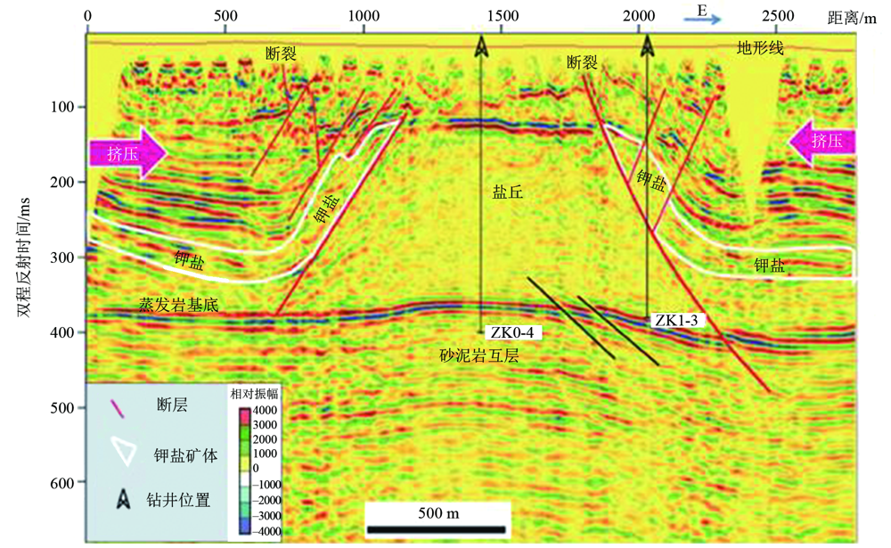
梁光河, 徐兴旺, 刘兴江, 等. 老挝万象盆地萨塔尼钾盐矿的构造变形与深部矿预测[J]. 大地构造与成矿学, 2019, 43(5):934-942.
|
| [25] |
吕古贤. 矿田地质分类研究[J]. 地学前缘, 2015, 22(4):1-12.
|
| [26] |
涂光炽. 祁连山的构造-岩相带[J]. 地质科学, 1959, 2(7):193-198.
|
| [27] |
陈国达. 成矿构造研究法[M]. 2版. 北京: 地质出版社, 1985: 1-421.
|
| [28] |
张文佑. 断块构造导论[M]. 北京: 石油工业出版社, 1984: 1-385.
|
| [29] |
刘光鼎. 用科学发展观统率矿产资源工作[J]. 中国科学院院刊, 2006, 21(3):240-244.
|
| [30] |
吕古贤, 李洪奎, 丁正江, 等. 胶东地区“岩浆核杂岩”隆起-拆离带岩浆期后热液蚀变成矿[J]. 现代地质, 2016, 30(2):247-262.
|
| [31] |
何昌成. 玲珑金矿田岩浆核杂岩隆起-拆离成矿构造解析与预测[D]. 北京: 中国地质大学(北京), 2018: 1-92.
|
| [32] |
徐述平. 招平断裂带金矿勘查模型与成矿预测[D]. 北京: 中国地质大学(北京), 2009: 1-186.
|
| [33] |
吕古贤, 武际春, 朱随洲, 等. 矿田地质学的概念和构造岩相分类[J]. 地质论评, 2016, 62(增刊1):321-322.
|
| [34] |
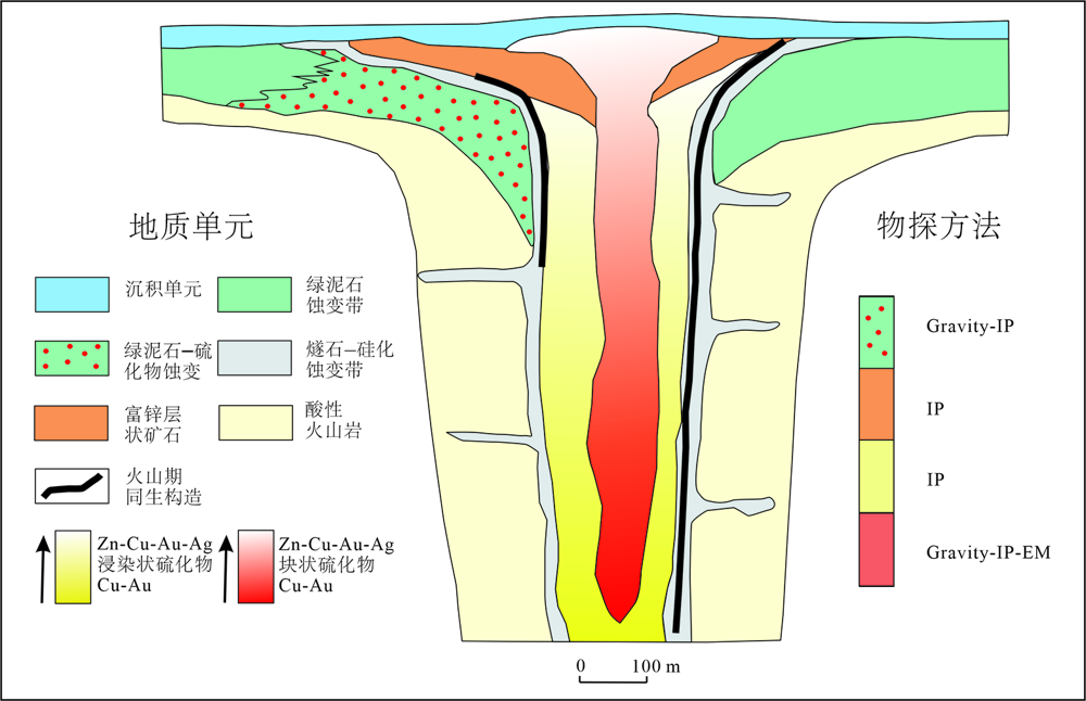
甘凤伟, 王京彬, 朱思才, 等. 埃塞俄比亚北部VMS型铜多金属矿快速勘查方法[J]. 矿产勘查, 2018, 9(8):1611-1621.
|
| [35] |
彭素霞, 程建新, 余吉远, 等. 北祁连清水沟—白柳沟矿田块状硫化物矿床成矿特征及找矿方向[J]. 西北地质, 2013, 46(4):142-150.
|
| [36] |
申屠良义, 韩润生, 李波, 等. 密西西比河谷型(MVT)铅锌矿床蚀变特征及研究展望[J]. 地球科学与环境学报, 2010, 32(增刊):142-144.
|
| [37] |
罗俊杰, 张建芳. Sedex型矿床地质特征及成矿物质来源示踪[J]. 资源环境与工程, 2010, 24(1):36-40.
|
| [38] |
李莎莎, 陈华勇, 汪礼明. 关于建立斑岩型铜矿床勘查标识体系的初步探讨[J]. 大地构造与成矿学, 2019, 43(5):991-1009.
|
| [39] |
姚佛军. 中国典型斑岩铜矿遥感蚀变分带模型研究[D]. 北京: 中国地质大学(北京), 2012: 1-263.
|
| [40] |
郭玉乾, 方维萱, 刘家军. 浅成低温热液金银多金属矿床矿化分带及找矿标志[J]. 矿产与地质, 2009, 23(1):7-14.
|
| [41] |
郭娜, 郭文铂, 刘栋, 等. 冈底斯成矿带陆相火山岩区浅成低温热液矿床蚀变分带模型: 以西藏斯弄多矿床为例[J]. 岩石学报, 2019, 35(3):833-848.
|
| [42] |
杜青松, 李志华, 鄂阿强, 等. 大兴安岭中南段夕卡岩型铅锌矿床地质特征及成因[J]. 矿产勘查, 2017, 8(3):366-373.
|
| [43] |
张叔贞, 林新多, 姚书振. 湖北张福山矿浆-热液过渡型矽卡岩铁矿蚀变矿化分带[J]. 地球科学: 中国地质大学学报, 1985, 10(4):45-51.
|
| [44] |
崔彬. 铜官山层控矽卡岩型铜矿床的蚀变分带及其成因[J]. 矿床地质, 1987, 6(1):35-44.
|
| [45] |
范潇, 吕古贤, 王宗永, 等. 焦家金矿田构造蚀变岩填图及其地球化学特征分析[J]. 地学前缘, 2015, 22(4):46-52.
|
| [46] |
周国发. 玲珑金矿田构造蚀变岩带及找矿预测研究[D]. 北京: 中国地质大学(北京), 2009: 1-113.
|
| [47] |
未晛, 杨志芳, 晏信飞. 地震勘探中的多尺度问题及其研究进展[J]. 地球物理学进展, 2019, 34(6):2353-2360.
|
 ), 吕古贤4,*(