地学前缘 ›› 2021, Vol. 28 ›› Issue (4): 100-109.DOI: 10.13745/j.esf.sf.2020.10.24
李少玲1( ), 谢苗苗1,2,*(), 李汉廷1, 王回茴1, 许萌1, 周伟1,2
收稿日期:2020-09-30
修回日期:2020-11-22
出版日期:2021-07-25
发布日期:2021-07-25
通讯作者:
谢苗苗
作者简介:李少玲(1993—),女,硕士,主要从事综合自然地理与景观生态研究。E-mail: lishaoling@cugb.edu.cn
基金资助:
LI Shaoling1(), XIE Miaomiao1,2,*(), LI Hanting1, WANG Huihui1, XU Meng1, ZHOU Wei1,2
Received:2020-09-30
Revised:2020-11-22
Online:2021-07-25
Published:2021-07-25
Contact:
XIE Miaomiao
摘要:
为探究大型露天煤矿开采对西北干旱荒漠区景观生态风险的影响,以及资源型城市转型背景下的时空动态,以资源衰退型的内蒙古自治区乌海市及周边县域为研究区,结合现有景观生态风险评价中的干扰度、脆弱度指标,增加受威胁指数来综合构建资源型城市景观生态风险评价框架。基于乌海市2005—2015年景观类型数据,从时间和空间上分析景观生态风险及其动态。结果显示:(1)2010—2015年景观类型之间转移相较于2005—2010年更剧烈,年变化强度分别为7.43%和3.44%,工矿用地与城市建设用地最活跃,但年增加强度减小。(2)林地、水域和湿地损失度先略增加后大幅度减小,其他土地和草地损失度呈增加趋势,工矿用地先减小后略增加;城市建设用地和工矿用地受威胁指数最大,其余类型的景观受威胁指数均有上升趋势,但其他土地、水域和湿地增加趋势逐渐减慢。(3)2005—2015年景观生态风险指数升高,空间分布总体呈西、中部高而南北低的格局,而不同等级风险区表现为低风险区由边缘向中心转移,而高风险区依托原有高风险区扩展。研究期风险区变化显著的是西部沙地高风险区,矿区东部其他土地因周围分布灌丛和草地,风险始终低于西部其他土地。根据不同风险等级中工矿用地的面积占比情况,将工矿用地占比控制在5%以内可达到控制总体景观生态风险的目的。研究为资源型城市通过合理的景观配置进行生态风险管控提供了依据。
中图分类号:
李少玲, 谢苗苗, 李汉廷, 王回茴, 许萌, 周伟. 资源型城市景观生态风险的时空分异:以乌海市为例[J]. 地学前缘, 2021, 28(4): 100-109.
LI Shaoling, XIE Miaomiao, LI Hanting, WANG Huihui, XU Meng, ZHOU Wei. Spatio-temporal dynamics of landscape ecological risk in resource-based cities: A case study of Wuhai[J]. Earth Science Frontiers, 2021, 28(4): 100-109.

图1 研究区示意图
Fig.1 Sketch map of the study area

图2 2005、2010、2015年乌海市景观类型分布
Fig.2 Landscape types for years 2005, 2010 and 2015
| 景观格局指数 | 计算公式 | 参数含义 |
|---|---|---|
| 景观破碎度指数( | | |
| 景观分离度指数( | | |
| 景观优势度指数( | | |
| 景观干扰度指数( | | a、b、c分别为破碎度、分离度与优势度的权重,且和为1 |
表1 景观干扰度指数计算
Table 1 Calculation of landscape disturbance index
| 景观格局指数 | 计算公式 | 参数含义 |
|---|---|---|
| 景观破碎度指数( | | |
| 景观分离度指数( | | |
| 景观优势度指数( | | |
| 景观干扰度指数( | | a、b、c分别为破碎度、分离度与优势度的权重,且和为1 |

图3 景观类型的年变化量
Fig.3 Annual variation in landscape types

图4 景观类型的年变化量
Fig.4 Annual change of landscape types
| 景观格局指数 | 年份 | 不同景观类型的各景观格局指数值 | |||||||
|---|---|---|---|---|---|---|---|---|---|
| 城市建设用地 | 工矿用地 | 灌丛 | 其他土地 | 水域和湿地 | 耕地 | 草地 | 林地 | ||
| 破碎度 | 2005 | 0.005 9 | 0.008 2 | 0.001 1 | 0.000 7 | 0.006 1 | 0.004 1 | 0.002 5 | 0.020 0 |
| 2010 | 0.004 6 | 0.003 0 | 0.001 5 | 0.000 9 | 0.006 9 | 0.004 0 | 0.003 2 | 0.021 4 | |
| 2015 | 0.004 0 | 0.003 5 | 0.002 3 | 0.001 9 | 0.001 0 | 0.004 1 | 0.004 1 | 0.017 1 | |
| 分离度 | 2005 | 0.261 9 | 0.246 9 | 0.027 4 | 0.025 5 | 0.152 9 | 0.153 7 | 0.057 0 | 0.846 9 |
| 2010 | 0.197 1 | 0.099 1 | 0.032 6 | 0.028 2 | 0.173 9 | 0.141 7 | 0.070 4 | 0.915 8 | |
| 2015 | 0.170 9 | 0.084 3 | 0.044 5 | 0.042 0 | 0.074 9 | 0.141 3 | 0.076 4 | 0.701 4 | |
| 优势度 | 2005 | 0.048 6 | 0.083 5 | 0.396 8 | 0.296 1 | 0.153 2 | 0.080 0 | 0.275 5 | 0.032 3 |
| 2010 | 0.056 1 | 0.113 7 | 0.399 4 | 0.300 9 | 0.140 5 | 0.085 5 | 0.247 6 | 0.030 2 | |
| 2015 | 0.057 9 | 0.181 0 | 0.362 8 | 0.335 3 | 0.053 6 | 0.083 8 | 0.286 1 | 0.034 4 | |
| 干扰度 | 2005 | 0.091 3 | 0.094 9 | 0.088 1 | 0.067 2 | 0.079 6 | 0.064 2 | 0.073 5 | 0.270 5 |
| 2010 | 0.072 7 | 0.054 0 | 0.090 4 | 0.069 1 | 0.083 7 | 0.061 6 | 0.072 2 | 0.291 5 | |
| 2015 | 0.064 8 | 0.063 2 | 0.087 1 | 0.080 6 | 0.033 7 | 0.061 2 | 0.082 2 | 0.225 9 | |
| 损失度 | 2005 | 0.044 1 | 0.046 2 | 0.107 5 | 0.164 5 | 0.155 9 | 0.109 7 | 0.107 5 | 0.264 5 |
| 2010 | 0.035 4 | 0.026 8 | 0.110 5 | 0.168 5 | 0.163 1 | 0.105 2 | 0.106 2 | 0.284 3 | |
| 2015 | 0.035 6 | 0.035 6 | 0.121 5 | 0.224 5 | 0.074 8 | 0.119 0 | 0.137 4 | 0.251 5 | |
| 受威胁度 | 2005 | 1.000 0 | 1.000 0 | 0.181 5 | 0.120 8 | 0.086 3 | 0.198 3 | 0.099 3 | 0.139 9 |
| 2010 | 1.000 0 | 1.000 0 | 0.126 1 | 0.209 6 | 0.142 3 | 0.196 7 | 0.182 5 | 0.162 1 | |
| 2015 | 1.000 0 | 1.000 0 | 0.256 5 | 0.243 4 | 0.157 4 | 0.239 2 | 0.290 8 | 0.190 5 | |
| 风险指数 | 2005 | 0.522 0 | 0.523 1 | 0.144 5 | 0.142 7 | 0.121 1 | 0.154 0 | 0.103 4 | 0.202 2 |
| 2010 | 0.517 7 | 0.513 4 | 0.118 3 | 0.189 0 | 0.152 7 | 0.150 9 | 0.144 4 | 0.223 2 | |
| 2015 | 0.517 8 | 0.517 8 | 0.189 0 | 0.234 0 | 0.116 1 | 0.179 1 | 0.214 1 | 0.221 0 | |
表2 各景观类型的景观格局指数变化一览表
Table 2 Temporal variation of landscape indexes for each landscape type in Wuhai
| 景观格局指数 | 年份 | 不同景观类型的各景观格局指数值 | |||||||
|---|---|---|---|---|---|---|---|---|---|
| 城市建设用地 | 工矿用地 | 灌丛 | 其他土地 | 水域和湿地 | 耕地 | 草地 | 林地 | ||
| 破碎度 | 2005 | 0.005 9 | 0.008 2 | 0.001 1 | 0.000 7 | 0.006 1 | 0.004 1 | 0.002 5 | 0.020 0 |
| 2010 | 0.004 6 | 0.003 0 | 0.001 5 | 0.000 9 | 0.006 9 | 0.004 0 | 0.003 2 | 0.021 4 | |
| 2015 | 0.004 0 | 0.003 5 | 0.002 3 | 0.001 9 | 0.001 0 | 0.004 1 | 0.004 1 | 0.017 1 | |
| 分离度 | 2005 | 0.261 9 | 0.246 9 | 0.027 4 | 0.025 5 | 0.152 9 | 0.153 7 | 0.057 0 | 0.846 9 |
| 2010 | 0.197 1 | 0.099 1 | 0.032 6 | 0.028 2 | 0.173 9 | 0.141 7 | 0.070 4 | 0.915 8 | |
| 2015 | 0.170 9 | 0.084 3 | 0.044 5 | 0.042 0 | 0.074 9 | 0.141 3 | 0.076 4 | 0.701 4 | |
| 优势度 | 2005 | 0.048 6 | 0.083 5 | 0.396 8 | 0.296 1 | 0.153 2 | 0.080 0 | 0.275 5 | 0.032 3 |
| 2010 | 0.056 1 | 0.113 7 | 0.399 4 | 0.300 9 | 0.140 5 | 0.085 5 | 0.247 6 | 0.030 2 | |
| 2015 | 0.057 9 | 0.181 0 | 0.362 8 | 0.335 3 | 0.053 6 | 0.083 8 | 0.286 1 | 0.034 4 | |
| 干扰度 | 2005 | 0.091 3 | 0.094 9 | 0.088 1 | 0.067 2 | 0.079 6 | 0.064 2 | 0.073 5 | 0.270 5 |
| 2010 | 0.072 7 | 0.054 0 | 0.090 4 | 0.069 1 | 0.083 7 | 0.061 6 | 0.072 2 | 0.291 5 | |
| 2015 | 0.064 8 | 0.063 2 | 0.087 1 | 0.080 6 | 0.033 7 | 0.061 2 | 0.082 2 | 0.225 9 | |
| 损失度 | 2005 | 0.044 1 | 0.046 2 | 0.107 5 | 0.164 5 | 0.155 9 | 0.109 7 | 0.107 5 | 0.264 5 |
| 2010 | 0.035 4 | 0.026 8 | 0.110 5 | 0.168 5 | 0.163 1 | 0.105 2 | 0.106 2 | 0.284 3 | |
| 2015 | 0.035 6 | 0.035 6 | 0.121 5 | 0.224 5 | 0.074 8 | 0.119 0 | 0.137 4 | 0.251 5 | |
| 受威胁度 | 2005 | 1.000 0 | 1.000 0 | 0.181 5 | 0.120 8 | 0.086 3 | 0.198 3 | 0.099 3 | 0.139 9 |
| 2010 | 1.000 0 | 1.000 0 | 0.126 1 | 0.209 6 | 0.142 3 | 0.196 7 | 0.182 5 | 0.162 1 | |
| 2015 | 1.000 0 | 1.000 0 | 0.256 5 | 0.243 4 | 0.157 4 | 0.239 2 | 0.290 8 | 0.190 5 | |
| 风险指数 | 2005 | 0.522 0 | 0.523 1 | 0.144 5 | 0.142 7 | 0.121 1 | 0.154 0 | 0.103 4 | 0.202 2 |
| 2010 | 0.517 7 | 0.513 4 | 0.118 3 | 0.189 0 | 0.152 7 | 0.150 9 | 0.144 4 | 0.223 2 | |
| 2015 | 0.517 8 | 0.517 8 | 0.189 0 | 0.234 0 | 0.116 1 | 0.179 1 | 0.214 1 | 0.221 0 | |
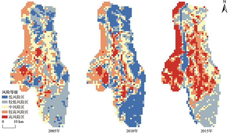
图5 2005、2010、2015年乌海市景观生态风险等级分布
Fig.5 Distribution of ecological risk types in Wuhai in 2005, 2010 and 2015
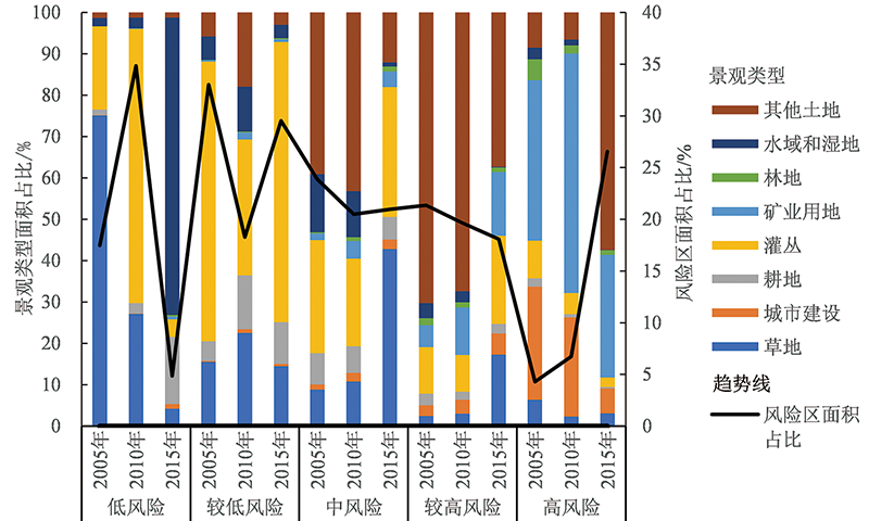
图6 不同风险等级中景观类型与风险区面积占比变化趋势
Fig.6 Variation trends of landscape type and risk area percentages for different risk levels
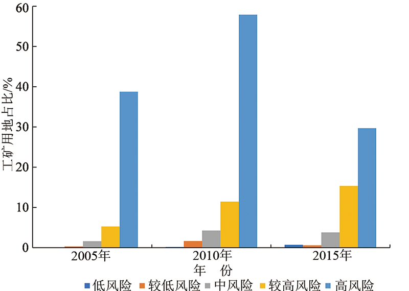
图7 2005年、2010年和2015年不同风险等级中工矿用地占比
Fig.7 Industrial/mining land percentage in 2005, 2010 and 2015 for different risk levels
| [1] | 刘合, 赵喆, 张国生, 等. 石油资源型城市转型的思考与探索: 以大庆市(大庆油田)为例[J]. 大庆石油地质与开发, 2019, 38(5):18-22. |
| [2] | 张琪, 郑刘根, 刘辉, 等. 煤炭资源型城市生态-经济-社会协调发展分析: 以淮南市为例[J]. 应用生态学报, 2019, 30(12):4313-4322. |
| [3] |
彭建, 党威雄, 刘焱序, 等. 景观生态风险评价研究进展与展望[J]. 地理学报, 2015, 70(4):664-677.
DOI |
| [4] | 张雪梨, 何如海. 安徽省资源型城市土地利用与生态环境耦合协调发展研究[J]. 沈阳农业大学学报(社会科学版), 2019, 21(5):513-518. |
| [5] | 叶菁, 谢巧巧, 谭宁焱. 基于生态承载力的国土空间开发布局方法研究[J]. 农业工程学报, 2017, 33(11):262-271. |
| [6] |
张新林, 仇方道, 谭俊涛, 等. 中国工业生态效率时空分异特征及其影响因素解析[J]. 地理科学, 2020, 40(3):335-343.
DOI |
| [7] | 刘慧, 师学义. 静乐县生态脆弱性时空演变与分区研究[J]. 生态与农村环境学报, 2020, 36(1):34-43. |
| [8] | 许凤娇, 吕晓. 基于土地利用变化的江苏沿海地区生态风险格局[J]. 生态学报, 2018, 38(20):7312-7325. |
| [9] | 彭建, 刘焱序, 潘雅婧, 等. 基于景观格局-过程的城市自然灾害生态风险研究: 回顾与展望[J]. 地球科学进展, 2014, 29(10):1186-1196. |
| [10] |
XUE L Q, ZHU B L, WU Y P, et al. Dynamic projection of ecological risk in the Manas River basin based on terrain gradients[J]. Science of the Total Environment, 2019, 653:283-293.
DOI URL |
| [11] | 贾艳艳, 唐晓岚, 刘振威, 等. 长江沿岸芜湖区段景观生态风险时空演变分析[J]. 中南林业科技大学学报, 2019, 39(11):78-87. |
| [12] | 张天华, 王彤, 黄琼中, 等. 西藏高原拉萨河流域生态风险评估[J]. 生态学报, 2018, 38(24):9012-9020. |
| [13] | 刘瑞程, 沈春竹, 贾振毅, 等. 道路景观胁迫下沿海滩涂地区生态网络构建与优化: 以盐城市大丰区为例[J]. 生态学杂志, 2019, 38(3):828-837. |
| [14] | 潘竟虎, 刘晓. 疏勒河流域景观生态风险评价与生态安全格局优化构建[J]. 生态学杂志, 2016, 35(3):791-799. |
| [15] | 何珍珍, 王宏卫, 杨胜天, 等. 渭干河: 库车河绿洲景观生态安全时空分异及格局优化[J]. 生态学报, 2019, 39(15):5473-5482. |
| [16] |
李青圃, 张正栋, 万露文, 等. 基于景观生态风险评价的宁江流域景观格局优化[J]. 地理学报, 2019, 74(7):1420-1437.
DOI |
| [17] | 吕乐婷, 张杰, 孙才志, 等. 基于土地利用变化的细河流域景观生态风险评估[J]. 生态学报, 2018, 38(16):5952-5960. |
| [18] | 龚俊杰, 杨华, 邓华锋. 北京明长城沿线景观生态风险评价[J]. 北京林业大学学报, 2015, 37(8):60-68. |
| [19] | 贡璐, 鞠强, 潘晓玲. 博斯腾湖区域景观生态风险评价研究[J]. 干旱区资源与环境, 2007, 21(1):27-31. |
| [20] | 姜坤, 陈娟, 戴文远, 等. 福州鼓岭避暑旅游区景观格局及生态风险分析[J]. 福建师范大学学报(自然科学版), 2019, 35(1):102-109. |
| [21] | JIN X, JIN Y X, MAO X F. Ecological risk assessment of cities on the Tibetan Plateau based on land use/land cover changes: case study of Delingha City[J]. Ecological Indicators, 2019, 101:185-191. |
| [22] | 马胜, 梁小英, 刘迪, 等. 生态脆弱区多尺度景观生态风险评价: 以陕西省米脂县高渠乡为例[J]. 生态学杂志, 2018, 37(10):3171-3178. |
| [23] | 张月, 张飞, 周梅, 等. 干旱区内陆艾比湖区域景观生态风险评价及时空分异[J]. 应用生态学报, 2016, 27(1):233-242. |
| [24] | 谢余初, 巩杰, 赵彩霞. 甘肃白龙江流域水土流失的景观生态风险评价[J]. 生态学杂志, 2014, 33(3):702-708. |
| [25] | 王飞, 叶长盛, 华吉庆, 等. 南昌市城镇空间扩展与景观生态风险的耦合关系[J]. 生态学报, 2019, 39(4):1248-1262. |
| [26] |
CHEN J, DONG B, LI H R, et al. Study on landscape ecological risk assessment of Hooded Crane breeding and overwintering habitat[J]. Environmental Research, 2020, 187:109649.
DOI URL |
| [27] |
甄江红, 王亚丰, 田圆圆, 等. 城市空间扩展的生态环境效应研究: 以内蒙古呼和浩特市为例[J]. 地理研究, 2019, 38(5):1080-1091.
DOI |
| [28] | 周迪, 施平, 吴晓青, 等. 烟台市城镇空间扩展及区域景观生态风险[J]. 生态学杂志, 2014, 33(2):477-485. |
| [29] | 何莎莎, 李欣, 何春龙, 等. 基于土地利用变化的扬州市广陵区景观生态风险评价[J]. 南京师大学报(自然科学版), 2019, 42(1):139-148. |
| [30] | 王俊俊, 弓弼. 西咸新区景观格局演变及其生态风险分析[J]. 西北林学院学报, 2019, 34(2):250-256. |
| [31] |
ZHANG W, CHANG W, ZHU Z, et al. Landscape ecological risk assessment of Chinese coastal cities based on land use change[J]. Applied Geography, 2020, 117:102174.
DOI URL |
| [32] |
LIU S L, CUI B S, DONG S K, et al. Evaluating the influence of road networks on landscape and regional ecological risk: a case study in Lancang River Valley of Southwest China[J]. Ecological Engineering, 2008, 34(2):91-99.
DOI URL |
| [33] | LIN Y Y, HU X S, ZHENG X X, et al. Spatial variations in the relationships between road network and landscape ecological risks in the highest forest coverage region of China[J]. Ecological Indicators, 2019, 96:392-403. |
| [34] |
MO W B, WANG Y, ZHANG Y X, et al. Impacts of road network expansion on landscape ecological risk in a megacity, China: a case study of Beijing[J]. Science of the Total Environment, 2017, 574:1000-1011.
DOI URL |
| [35] | 中华人民共和国国务院. 国务院关于印发全国资源型城市可持续发展规划(2013—2020年)的通知[Z/OL]. (2013-11-12) [2020-05-14] http://www.gov.cn/zwgk/2013-12/03/content_2540070.htm . |
| [36] | 唐克旺, 范权, 于志永, 等 . 乌海: 从黑色到蓝色的战略转变: 缺水条件下水生态文明城市的机遇分析与建设任务[J]. 中国水利, 2014(7):5-7, 62. |
| [37] | 宁启蒙, 欧阳海燕, 汤放华, 等. 土地利用变化影响下洞庭湖地区景观格局的时空演变[J]. 经济地理, 2020, 40(9):196-203. |
| [38] | 刘孟竹, 王彦芳, 裴宏伟. 基于土地利用变化的河北省坝上地区景观生态风险评价[J]. 水土保持通报, 2020, 40(4):303-311, 345. |
| [39] | 李子君, 刘金玉, 鲁成秀, 等. 基于土地利用变化的沂河流域景观格局与径流关系的分析[J]. 中国农业大学学报, 2020, 25(10):11-19. |
| [40] | 付扬军, 师学义, 和娟. 汾河流域景观格局脆弱性时空分异特征[J]. 水土保持研究, 2020, 27(3):197-202. |
| [41] | 赵越, 罗志军, 李雅婷, 等. 赣江上游流域景观生态风险的时空分异: 从生产-生活-生态空间的视角[J]. 生态学报, 2019, 39(13):4676-4686. |
| [42] | 林美霞, 吝涛, 邱全毅, 等. 不同类型城市快速扩张区域人工景观对自然景观的生态安全胁迫效应比较[J]. 应用生态学报, 2017, 28(4):1326-1336. |
| [43] | 吝涛, 薛雄志, 崔胜辉, 等. 快速城市化进程中海岛景观格局变化研究[J]. 海洋环境科学, 2009, 28(1):87-91. |
| [44] | 常小燕, 李新举, 李西灿, 等. 矿区土地利用生态风险的时空异质性[J]. 生态学报, 2019, 39(9):3075-3088. |
| [45] | 刘珍环, 张国杰, 付凤杰. 基于景观格局-服务的景观生态风险评价: 以广州市为例[J]. 生态学报, 2020, 40(10):3295-3302. |
| [46] | 韩会庆, 李金艳, 陈思盈, 等. 喀斯特地区贫困乡村景观格局及生态风险分析[J]. 农业资源与环境学报, 2020, 37(2):161-168. |
| [47] | 李俊翰, 高明秀. 滨州市生态系统服务价值与生态风险时空演变及其关联性[J]. 生态学报, 2019, 39(21):7815-7828. |
| [48] | WANG R H, FAN Z L. Study on the evaluation of ecological frangibility of Tarim River Basin[J]. Arid Environmental Monitoring, 1998, 12(4):39-44. |
| [49] |
时卉, 杨兆萍, 韩芳, 等. 新疆天池景区生态安全度时空分异特征与驱动机制[J]. 地理科学进展, 2013, 32(3):475-485.
DOI |
| [50] | 奚世军, 安裕伦, 李阳兵, 等. 基于景观格局的喀斯特山区流域生态风险评估: 以贵州省乌江流域为例[J]. 长江流域资源与环境, 2019, 28(3):712-721. |
| [51] |
刘迪, 陈海, 耿甜伟, 等. 基于地貌分区的陕西省区域生态风险时空演变[J]. 地理科学进展, 2020, 39(2):243-254.
DOI |
| [52] | 石浩朋, 于开芹, 冯永军. 基于景观结构的城乡结合部生态风险分析: 以泰安市岱岳区为例[J]. 应用生态学报, 2013, 24(3):705-712. |
| [53] | 游巍斌, 何东进, 巫丽芸, 等. 武夷山风景名胜区景观生态安全度时空分异规律[J]. 生态学报, 2011, 31(21):6317-6327. |
| [54] |
O’NEILL R V, HUNSAKER C T, TIMMINS S P, et al. Scale problems in reporting landscape pattern at the regional scale[J]. Landscape Ecology, 1996, 11(3):169-180.
DOI URL |
| [55] | 王涛, 肖彩霞, 刘娇, 等. 云南高原湖泊杞麓湖动态演变及景观生态风险评价[J]. 浙江农林大学学报, 2020, 37(1):9-17. |
| [56] | 王鹏, 王亚娟, 刘小鹏, 等. 基于景观结构的生态移民安置区生态风险评价: 以宁夏红寺堡区为例[J]. 生态学报, 2018, 38(8):2672-2682. |
| [57] | 杨阳, 黄义雄, 李潇, 等. 海坛岛景观生态风险评价及时空分异[J]. 福建师范大学学报(自然科学版), 2018, 34(2):74-81. |
| [58] | 徐兰, 罗维, 周宝同. 基于土地利用变化的农牧交错带典型流域生态风险评价: 以洋河为例[J]. 自然资源学报, 2015, 30(4):580-590. |
| [59] |
ANTENEH Y, STELLMACHER T, ZELEKE G, et al. Dynamics of land change: insights from a three-level intensity analysis of the Legedadie-Dire catchments, Ethiopia[J]. Environmental Monitoring and Assessment, 2018, 190(5):309.
DOI URL |
| [1] | 张凤荣, 周建, 徐艳, 陈竞元. 基于地学规律的科尔沁沙地土地整治与生态修复规划方法[J]. 地学前缘, 2021, 28(4): 35-41. |
| [2] | 张明浩, 赵廷宁, 肖辉杰. 内蒙古乌海粉尘浓度时空分布及影响因素探析[J]. 地学前缘, 2021, 28(4): 118-130. |
| [3] | 张素荣, 王昌宇, 刘继红, 邢怡, 刘庆学, 杨俊泉, 贺福清. 雄安新区西南部土壤重金属污染特征及生态风险评价[J]. 地学前缘, 2021, 28(4): 238-249. |
| [4] | 曹永生,郭华明,倪萍,李山羊,郭琦,韩双宝,李付兰. 沉积物地球化学特征和土地利用方式对地下水砷行为的影响[J]. 地学前缘, 2017, 24(2): 274-285. |
| [5] | 杨柯, 姜建军, 刘飞, 白中科. 平朔露天煤矿复垦区土壤中多环芳烃分布特征、来源解析及风险分析[J]. 地学前缘, 2016, 23(5): 281-290. |
| [6] | 夏学齐, 杨忠芳, 余涛, 侯青叶, 白荣杰, 崔玉军. 中国东北地区20世纪末土地利用变化的土壤碳源汇效应[J]. 地学前缘, 2011, 18(6): 56-63. |
| [7] | 杨柯, 刘国栋, 刘飞, 赵传冬, 刘应汉, 彭敏, 李括. 扎龙湿地水旱交错区土壤呼吸研究[J]. 地学前缘, 2011, 18(6): 94-100. |
| [8] | 张建新 邢旭东 鲁江 吕焕哲. 洞庭湖区土壤实测碳量的分布规律及其对全球变化的响应[J]. 地学前缘, 2008, 15(5): 57-66. |
| [9] | 王冬银; 章程; 谢世友; 杨平恒; 张文晖;. 山区岩溶作用对土地利用方式的响应——以金佛山碧潭泉和水房泉两区岩溶系统为例 [J]. 地学前缘, 2007, 14(6): 222-230. |
| 阅读次数 | ||||||
|
全文 |
|
|||||
|
摘要 |
|
|||||