Earth Science Frontiers ›› 2022, Vol. 29 ›› Issue (3): 292-303.DOI: 10.13745/j.esf.sf.2022.1.55
Previous Articles Next Articles
ZHENG Qifang( ), ZHENG Yuzhou(), ZHAO Rui, KUANG Xingtao, ZHANG Wan, LIU Yinghui, XU Luping, WU Yun, ZHOU Daoqing
Received:2021-11-09
Revised:2022-01-13
Online:2022-05-25
Published:2022-04-28
Contact:
ZHENG Yuzhou
CLC Number:
ZHENG Qifang, ZHENG Yuzhou, ZHAO Rui, KUANG Xingtao, ZHANG Wan, LIU Yinghui, XU Luping, WU Yun, ZHOU Daoqing. Gravity and magnetic anomaly in the southern Tanlu fault zone and its geological interpretation[J]. Earth Science Frontiers, 2022, 29(3): 292-303.

Fig.1 (a) Simplified structural map of the central and southern parts of the Tanlu fault zone (modified from [9]) and (b) geological map of the study area (adapted from Anhui Geological Survey and Environmental Monitoring Center)

Fig.2 Airborne magnetic anomaly maps of the Hefei Basin and surrounding areas

Fig.3 Airborne gravity anomaly maps of the Hefei Basin and surrounding areas
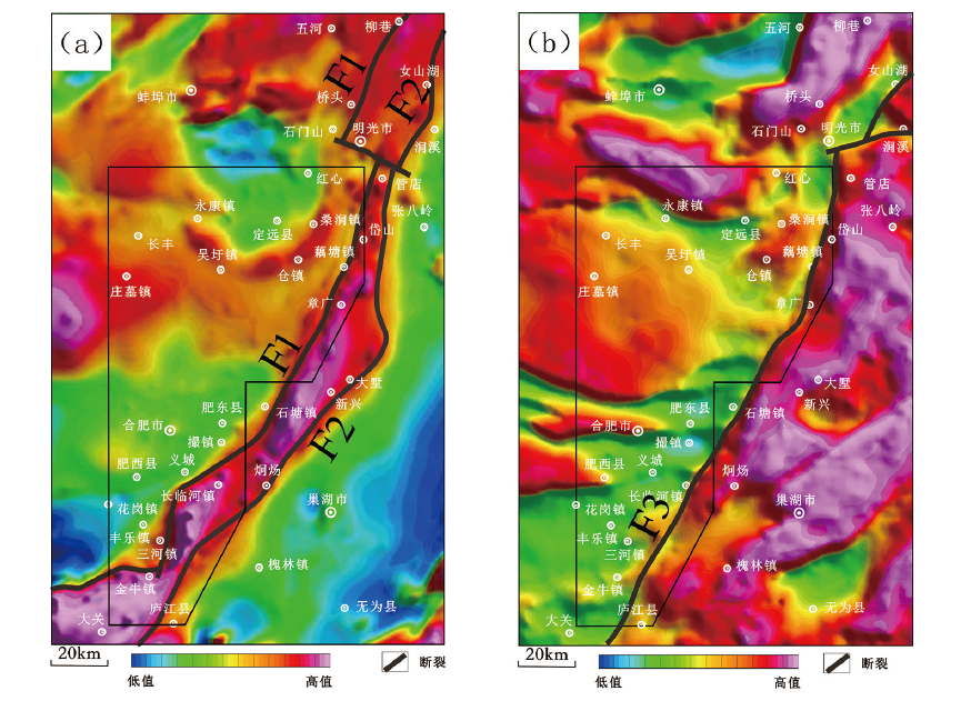
Fig.4 Large scale magnetic and gravity anomaly maps of the Hefei segment of the Tanlu fault zone
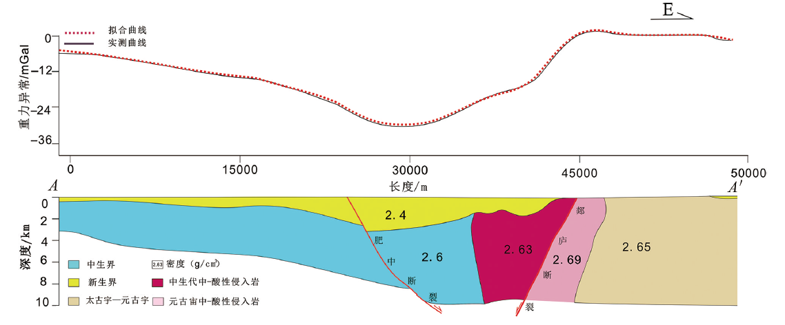
Fig.5 Inversion of Ground Bouguer-corrected gravity anomaly along profile AA' of the Tanlu fault zone
| [1] |
DENG Y F, FAN W M, ZHANG Z J, et al. Geophysical evidence on segmentation of the Tancheng-Lujiang fault and its implications on the lithosphere evolution in East China[J]. Journal of Asian Earth Sciences, 2013, 78: 263-276.
DOI URL |
| [2] | YE T, CHEN A Q, HOU M C, et al. Characteristic of the Bodong segment of the Tanlu Fault Zone, Bohai Sea area, Eastern China: implications for hydrocarbon exploration and regional tectonic evolution[J]. Journal of Petroleum Science and Engineering, 2021, 201: 108478. |
| [3] | 吴根耀, 梁兴, 陈焕疆. 试论郯城-庐江断裂带的形成、演化及其性质[J]. 地质科学, 2007, 42(1): 160-175. |
| [4] | 张鹏, 王良书, 钟锴, 等. 郯庐断裂带的分段性研究[J]. 地质论评, 2007, 53(5): 586-591,721. |
| [5] | 李开洋, 王成虎, 邢博瑞, 等. 郯庐断裂带区域应力状态研究综述[J]. 大地测量与地球动力学, 2014, 34(6): 1-8,13. |
| [6] |
HUANG L, LIU C Y, KUSKY T M. Cenozoic evolution of the Tan-Lu Fault Zone (East China): constraints from seismic data[J]. Gondwana Research, 2015, 28(3): 1079-1095.
DOI URL |
| [7] |
ZHANG Y Q, DONG S W, SHI W. Cretaceous deformation history of the middle Tan-Lu fault zone in Shandong Province, Eastern China[J]. Tectonophysics, 2003, 363(3/4): 243-258.
DOI URL |
| [8] |
ZHANG J D, HAO T Y, DONG S W, et al. The structural and tectonic relationships of the major fault systems of the Tan-Lu fault zone, with a focus on the segments within the North China region[J]. Journal of Asian Earth Sciences, 2015, 110: 85-100.
DOI URL |
| [9] |
ZHAO T, ZHU G, LIN S Z, et al. Indentation-induced tearing of a subducting continent: evidence from the Tan-Lu fault zone, East China[J]. Earth-Science Reviews, 2016, 152: 14-36.
DOI URL |
| [10] |
ZHU G, HU W, SONG L H, et al. Quaternary activity along the Tan-Lu fault zone in the Bohai Bay, East China: evidence from seismic profiles[J]. Journal of Asian Earth Sciences, 2015, 114: 5-17.
DOI URL |
| [11] | 朱光, 刘程, 顾承串, 等. 郯庐断裂带晚中生代演化对西太平洋俯冲历史的指示[J]. 中国科学: 地球科学, 2018, 48(4): 415-435. |
| [12] | 赵田, 谢成龙, 向必伟, 等. 脆-韧性转换带变形过程与机制: 以郯庐断裂带南段为例[J]. 大地构造与成矿学, 2019, 43(1): 17-32. |
| [13] |
GU H O, XIAO Y L, SANTOSH M, et al. Spatial and temporal distribution of Mesozoic adakitic rocks along the Tan-Lu fault, Eastern China: constraints on the initiation of lithospheric thinning[J]. Lithos, 2013, 177: 352-365.
DOI URL |
| [14] | 张家声. 沂沭断裂带中段基底韧性剪切带[J]. 地震地质, 1983, 5(2): 11-23, 93. |
| [15] | 方仲景, 丁梦林, 向宏发, 等. 郯庐断裂带的基本特征[J]. 科学通报, 1986, 31(1): 52-55. |
| [16] | 张家声. 郯庐剪切带的性质和意义[J]. 地球科学: 中国地质大学学报, 1992, 17(4): 363-372, 485. |
| [17] | 乔秀夫, 高林志, 彭阳, 等. 古郯庐带沧浪铺阶地震事件、 层序及构造意义[J]. 中国科学D辑: 地球科学, 2001, 31(11): 911-918. |
| [18] | CHUNG S L, LO C H, LAN C Y, et al. Collision between the indochina and South China blocks in the Early Triassic: implications for the Indosinian orogeny and closure of eastern Paleo-Tethys[J]. Eos Transactions, American Geophysical Union, 1999, 80(46): F1043. |
| [19] | 赵田. 郯庐断裂带南段造山期变形格局、 演化规律与形成机制[D]. 合肥: 合肥工业大学, 2016. |
| [20] | 尚德锋. 郯庐断裂带肥东地区中生代花岗岩成因与构造背景[D]. 合肥: 合肥工业大学, 2018. |
| [21] | 许志琴, 张巧大, 赵民. 郯庐断裂中段古裂谷的基本特征[J]. 中国地质科学院院报, 1982, 3: 17-44. |
| [22] | 王小凤, 李中坚, 陈柏林, 等. 郯庐断裂带[M]. 北京: 地质出版社, 2000: 67-71. |
| [23] | 朱光, 王道轩, 刘国生, 等. 郯庐断裂带的伸展活动及其动力学背景[J]. 地质科学, 2001, 36(3): 269-278. |
| [24] | 陈青, 袁炳强, 董云鹏, 等. 断裂识别新方法及其在肯尼亚Tana凹陷中的应用[J]. 西北大学学报(自然科学版), 2013, 43(4): 599-605. |
| [25] | 张婉, 张玄杰, 佟晶, 等. 日照-连云港地区重磁异常特征及其构造意义[J]. 地球科学, 2018, 43(12): 4490-4497. |
| [26] | 付翔, 张达玉, 邓宇峰, 等. 郯庐断裂带内发现晋宁期花岗岩[C]// 第九届全国成矿理论与找矿方法学术讨论会论文摘要集, 北京: 矿物学报编辑部, 2019: 2. |
| [27] | 王万银, 邱之云, 杨永, 等. 位场边缘识别方法研究进展[J]. 地球物理学进展, 2010, 25(1): 196-210. |
| [28] | 王万银. 位场总水平导数极值位置空间变化规律研究[J]. 地球物理学报, 2010, 53(9): 2257-2270. |
| [29] | 熊盛青. 航空地球物理勘查科技创新与应用[J]. 地质力学学报, 2020, 26(5): 791-818. |
| [30] |
ZHU G, LIU C, GU C C, et al. Oceanic plate subduction history in the western Pacific Ocean: constraint from late Mesozoic evolution of the Tan-Lu Fault Zone[J]. Science China Earth Sciences, 2018, 61(4): 386-405.
DOI URL |
| [31] | FU X, ZHANG D Y, YAO Z W, et al. Geochronology and petrogenesis of granitoid intrusions in the Feidong district, southern Tan-Lu fault zone, China[J]. Acta Geologica Sinica‐English Edition, 2020, 94(6): 1960-1976. |
| [32] | BEM T S, YAO H J, LUO S, et al. High-resolution 3-D crustal shear-wave velocity model reveals structural and seismicity segmentation of the central-southern Tanlu Fault zone, Eastern China[J]. Tectonophysics, 2020, 778: 228372. |
| [33] | 崔腾发. 郯庐-大别构造区地壳三维电性结构及其动力学意义[D]. 北京: 中国地震局地质研究所, 2019. |
| [34] |
YIN A, NIE S Y. An indentation model for the North and South China collision and the development of the Tan-Lu and Honam Fault Systems, eastern Asia[J]. Tectonics, 1993, 12(4): 801-813.
DOI URL |
| [35] | GILDER S A, LELOUP P H, COURTILLOT V, et al. Tectonic evolution of the Tancheng-Lujiang (Tan-Lu) fault via Middle Triassic to Early Cenozoic paleomagnetic data[J]. Journal of Geophysical Research: Solid Earth, 1999, 104(B7): 15365-15390. |
| [36] |
ZHU G, LIU G S, NIU M L, et al. Syn-collisional transform faulting of the Tan-Lu fault zone, East China[J]. International Journal of Earth Sciences, 2009, 98(1): 135-155.
DOI URL |
| [37] | 邓佳良, 储东如, 王翔, 等. 从断层擦痕反演的郯庐断裂带南段合肥盆地白垩纪构造应力场[J]. 地质科学, 2020, 55(2): 519-536. |
| [38] |
WANG Y. The onset of the Tan-Lu fault movement in eastern China: constraints from zircon (SHRIMP) and 40Ar/39Ar dating[J]. Terra Nova, 2006, 18(6): 423-431.
DOI URL |
| [39] | 孙晓猛, 刘永江, 孙庆春, 等. 敦密断裂带走滑运动的40Ar/39Ar年代学证据[J]. 吉林大学学报(地球科学版), 2008, 38(6): 965-972. |
| [40] | 顾承串, 朱光, 翟明见, 等. 依兰-伊通断裂带中生代走滑构造特征与起源时代[J]. 中国科学: 地球科学, 2016, 46(12): 1579-1601. |
| [41] |
ZHU G, JIANG D Z, ZHANG B L, et al. Destruction of the eastern North China Craton in a backarc setting: evidence from crustal deformation kinematics[J]. Gondwana Research, 2012, 22(1): 86-103.
DOI URL |
| [42] | 刘国生, 朱光, 牛漫兰, 等. 合肥盆地东部中-新生代的演化及其对郯庐断裂带活动的响应[J]. 地质科学, 2006, 41(2): 256-269. |
| [43] |
ZHU G, WANG Y S, WANG W, et al. An accreted micro-continent in the north of the Dabie Orogen, East China: evidence from detrital zircon dating[J]. Tectonophysics, 2017, 698: 47-64.
DOI URL |
| [44] | 朱光, 胡召齐, 陈印, 等. 华北克拉通东部早白垩世伸展盆地的发育过程及其对克拉通破坏的指示[J]. 地质通报, 2008, 27(10): 1594-1604. |
| [45] |
WU Y B, ZHENG Y F. Tectonic evolution of a composite collision orogen: an overview on the Qinling-Tongbai-Hong'an-Dabie-Sulu orogenic belt in central China[J]. Gondwana Research, 2013, 23(4): 1402-1428.
DOI URL |
| [46] |
ERNST W G, LIOU J G. Contrasting plate-tectonic styles of the Qinling-Dabie-Sulu and Franciscan metamorphic belts[J]. Geology, 1995, 23(4): 353-356.
DOI URL |
| [47] |
ZHANG K J. North and South China collision along the eastern and southern North China margins[J]. Tectonophysics, 1997, 270(1/2): 145-156.
DOI URL |
| [48] |
ZHENG Y F, XIAO W J, ZHAO G C. Introduction to tectonics of China[J]. Gondwana Research, 2013, 23(4): 1189-1206.
DOI URL |
| [49] | 汤加富, 许卫. 郯庐断裂带南段并无巨大平移: 来自安徽境内的证据[J]. 地质论评, 2002, 48(5): 449-456. |
| [50] | 高天山, 李惠民, 汤加富, 等. 大别造山带南缘浅粒岩的锆石U-Pb年龄及其地质意义[J]. 中国地质, 2002, 29(3): 301-304. |
| [51] | 郑永飞, 张少兵. 华南前寒武纪大陆地壳的形成和演化[J]. 科学通报, 2007, 52(1): 1-10. |
| [52] | 乔秀夫, 张安棣. 华北块体、 胶辽朝块体与郯庐断裂[J]. 中国地质, 2002, 29(4): 337-345. |
| [53] | 薛怀民, 马芳, 宋永勤, 等. 江南造山带东段新元古代花岗岩组合的年代学和地球化学: 对扬子与华夏地块拼合时间与过程的约束[J]. 岩石学报, 2010, 26(11): 3215-3244. |
| [54] | 王世伟. 长江中下游成矿带(安徽段)斑岩型矿床成岩成矿作用研究[D]. 合肥: 合肥工业大学, 2015. |
| [55] | 段吉业, 刘鹏举, 夏德馨. 浅析华北板块中元古代-古生代构造格局及其演化[J]. 现代地质, 2002, 16(4): 331-338. |
| [56] |
MENG Q R, WU G L, FAN L G, et al. Tectonic evolution of early Mesozoic sedimentary basins in the North China block[J]. Earth-Science Reviews, 2019, 190: 416-438.
DOI URL |
| [57] | 梁光河. 郯庐断裂带的几个关键问题探讨[J]. 黄金科学技术, 2018, 26(5): 543-558. |
| [58] | 薛金声, 李师汤. 山东沂沭断裂带成生时代探讨[J]. 山东海洋学院学报, 1982, 12(4): 51-59. |
| [59] | 中国自然资源航空物探遥感中心. 合肥盆地航空物探(磁)勘查成果报告[R]. 北京: 中国地质调查局中国自然资源航空物探遥感中心, 2001. |
| [60] | 王婷. 郯庐断裂带南段晚中生代火山岩成因研究[D]. 合肥: 合肥工业大学, 2019. |
| [61] | 牛漫兰, 朱光, 谢成龙, 等. 郯庐断裂带张八岭隆起南段晚中生代侵入岩地球化学特征及其对岩石圈减薄的指示[J]. 岩石学报, 2010, 26(9): 2783-2804. |
| [62] | 童劲松, 路玉林, 管运才, 等. 皖东地区燕山期高镁中酸性侵入岩地球化学特征及动力学意义[J]. 中国地质, 2008, 35(1): 18-31. |
| [63] | 谢成龙, 朱光, 牛漫兰, 等. 郯庐断裂带巢湖-庐江段晚中生代火山岩地球化学特征与岩石圈减薄过程[J]. 岩石学报, 2008, 24(8): 1823-1838. |
| [64] | 付翔. 郯庐断裂带南段肥东地区中酸性岩成因及对区域隆升指示[D]. 合肥: 合肥工业大学, 2021. |
| [65] | 徐汉林, 赵宗举, 吕福亮, 等. 南华北地区的构造演化与含油气性[J]. 大地构造与成矿学, 2004, 28(4): 450-463. |
| [66] | 戴寅, 胡望水, 汤济广, 等. 合肥盆地构造演化、差异变形及油气勘探前景[J]. 中国地质, 2011, 38(6): 1584-1592. |
| [67] | 邓晋福, 刘厚祥, 赵海玲, 等. 燕辽地区燕山期火成岩与造山模型[J]. 现代地质, 1996, 10(2): 137-148. |
| [68] | 吕俊祥, 黄泽光, 翟常博. 南华北地区中新生代盆地成盆环境分析[J]. 石油实验地质, 2005, 27(2): 118-123. |
| [69] | 鲁国明, 朱光, 李学田, 等. 郯庐断裂带对合肥盆地油气地质条件的控制[J]. 石油实验地质, 2002, 24(3): 216-222. |
| [1] | Xiaojun WANG, Yong SONG, Baoli BIAN, Junmeng ZHAO, Heng ZHANG, Maodu YAN, Shunping PEI, Qiang XU, Shuaijun WANG, Hongbing LIU, Changhui JU. Basement structure of the Junggar Basin [J]. Earth Science Frontiers, 2021, 28(6): 235-255. |
| [2] | WANG Yongsheng, TIAN Ziqiang, HU Zhaoqi, BAI Qiao. Provenance analysis of the Yuantongshan Formation in the Hefei Basin and its geological signature: evidences from detrital zircon dating [J]. Earth Science Frontiers, 2019, 26(2): 179-193. |
| Viewed | ||||||
|
Full text |
|
|||||
|
Abstract |
|
|||||