Earth Science Frontiers ›› 2021, Vol. 28 ›› Issue (1): 141-154.DOI: 10.13745/j.esf.sf.2020.5.14
Previous Articles Next Articles
ZHANG Zili1,2( ), ZHU Xiaomin1,2,*(), LIAO Fengying3, LI Qi4, ZHANG Ruifeng5, CAO Lanzhu5, SHI Ruisheng1,2
Received:2019-12-05
Revised:2020-05-19
Online:2021-01-25
Published:2021-01-28
Contact:
ZHU Xiaomin
CLC Number:
ZHANG Zili, ZHU Xiaomin, LIAO Fengying, LI Qi, ZHANG Ruifeng, CAO Lanzhu, SHI Ruisheng. Features and control factors of gentle-sloped fluvial sandbodies in rift basins: An example from the Wen’an Slope, Baxian Sag[J]. Earth Science Frontiers, 2021, 28(1): 141-154.

Fig.1 Location of the Wen’an Slope, Baxian Sag, Bohai Bay Basin and the structure of the Paleogene Baxian Sag
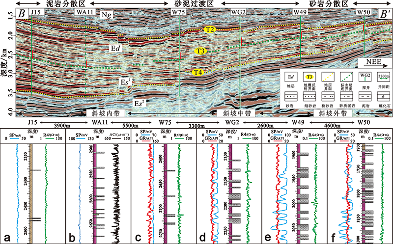
Fig.2 Seismic reflection and lithology along the provenance direction of Ed3 in the middle section of the Wen’an Slope, Baxian Sag (Profile location shown in Fig.1a)

Fig.3 Sedimentary palaeogeomorphological map of Ed3 in the middle section of the Wen’an Slope, Baxian Sag (See Fig.1a for location)

Fig.4 The fluvial microfacies composition and lithologic characteristics of Ed in the middle part of the Wen’an Slope, Baxian Sag
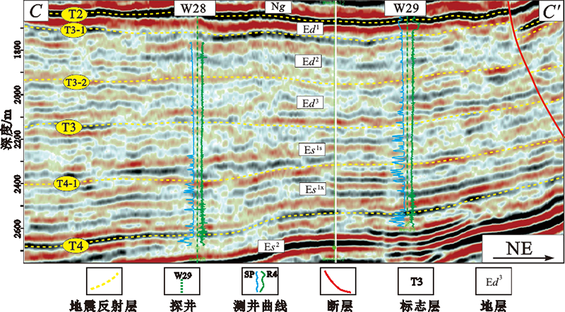
Fig.5 Seismic reflection characteristics and stratigraphic division of the Wen’an Slope, Baxian Sag

Fig.6 Sedimentary facies, slice interpretation and lithologic-electrical characteristics of Ed3 in the middle section of the Wen’an Slope, Baxian Sag

Fig.7 Sedimentary facies of Ed3 in the middle section of the Wen’an Slope, Baxian Sag (See Fig.3 for location)
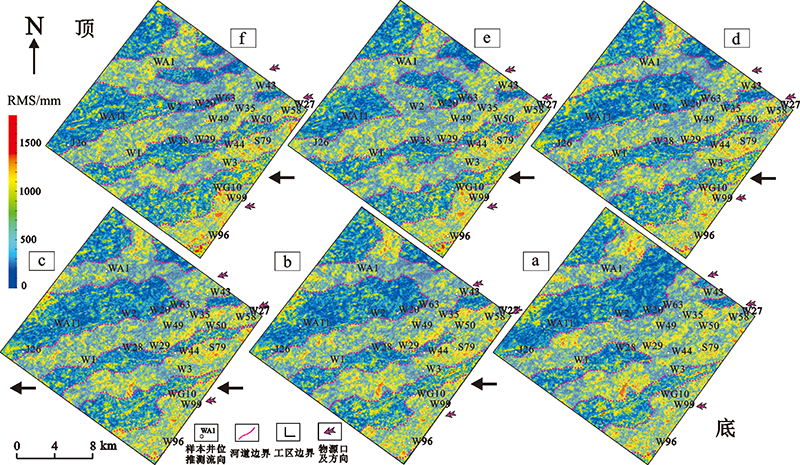
Fig.8 Stratigraphic slices and channel evolutionary characteristics of Ed3 in the middle section of the Wen’an Slope, Baxian Sag

Fig.9 Quantitative analysis of channel in the middle section of the Wen’an Slope, Baxian Sag (profile position shown in Fig.3). Adapted from [27].
| 剖 面 | 河道带宽 度L/km | 主河道带宽 度W/km | 河道带视宽 度l/km | 主河道带视 宽度w/km | 河道带厚 度H/m | 河道带平均 厚度h/m | 主河道带 厚度D/m | 主河道带平 均厚度d/m | 岩电解释河 道厚度C/m | 河道带宽 深比P | 主河道带 宽深比p |
|---|---|---|---|---|---|---|---|---|---|---|---|
| a | 1.1 | 0.12~0.27 | 0.72~0.86 | 78~210 | 16~32 | 22 | 12~23 | 18 | |||
| b | 2.25 | 0.16~0.75 | 1.47~1.75 | 104~583 | 24~43 | 32 | 10~20 | 15 | 45.9~54.7 | 6.9~35.9 | |
| c | 3.15 | 0.06~0.65 | 2.01~2.45 | 39~505 | 17~51 | 34 | 12~25 | 18 | 59.1~72.1 | 2.2~28.1 | |
| d | 2.5 | 0.05~0.55 | 1.63~1.94 | 33~427 | 19~45 | 35 | 8~22 | 16 | 4~16.5 | 46.6~55.4 | 2.1~26.7 |
| e | 2.45 | 0.03~0.58 | 1.60~1.91 | 119~451 | 17~43 | 33 | 8~18 | 13 | 1.5~8.8 | 48.5~57.9 | 1.5~34.7 |
| f | 3.4 | 0.04~0.41 | 2.22~2.64 | 26~318 | 20~52 | 39 | 6~14 | 8 | 1~4.4 | 56.9~67.7 | 2.6~31.8 |
Table 1 River channel parameters for Ed3 in the middle section of the Wen’an Slope, Baxian Sag
| 剖 面 | 河道带宽 度L/km | 主河道带宽 度W/km | 河道带视宽 度l/km | 主河道带视 宽度w/km | 河道带厚 度H/m | 河道带平均 厚度h/m | 主河道带 厚度D/m | 主河道带平 均厚度d/m | 岩电解释河 道厚度C/m | 河道带宽 深比P | 主河道带 宽深比p |
|---|---|---|---|---|---|---|---|---|---|---|---|
| a | 1.1 | 0.12~0.27 | 0.72~0.86 | 78~210 | 16~32 | 22 | 12~23 | 18 | |||
| b | 2.25 | 0.16~0.75 | 1.47~1.75 | 104~583 | 24~43 | 32 | 10~20 | 15 | 45.9~54.7 | 6.9~35.9 | |
| c | 3.15 | 0.06~0.65 | 2.01~2.45 | 39~505 | 17~51 | 34 | 12~25 | 18 | 59.1~72.1 | 2.2~28.1 | |
| d | 2.5 | 0.05~0.55 | 1.63~1.94 | 33~427 | 19~45 | 35 | 8~22 | 16 | 4~16.5 | 46.6~55.4 | 2.1~26.7 |
| e | 2.45 | 0.03~0.58 | 1.60~1.91 | 119~451 | 17~43 | 33 | 8~18 | 13 | 1.5~8.8 | 48.5~57.9 | 1.5~34.7 |
| f | 3.4 | 0.04~0.41 | 2.22~2.64 | 26~318 | 20~52 | 39 | 6~14 | 8 | 1~4.4 | 56.9~67.7 | 2.6~31.8 |
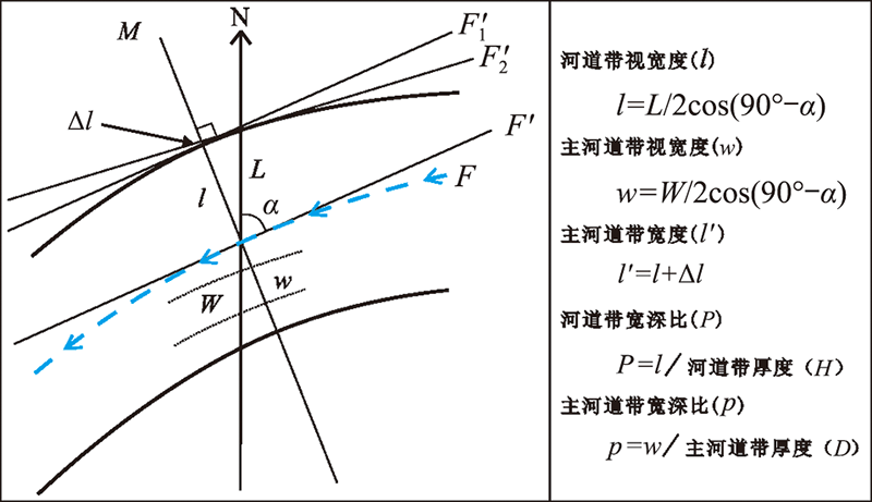
Fig.10 Relationship among fluvial parameters for Ed3 in the middle section of the Wen’an Slope, Baxian Sag. Adapted from [27].
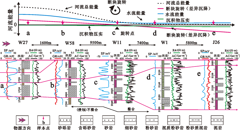
Fig.11 Controlling factors for and evolution of fluvial facies and vertical sounding analysis of single stage channels in Ed3 along the flow direction in the middle scation of the Wen’an Slope, Baxian Sag

Fig.12 Fluvial profile structure and lithologic characteristics of Ed3 along the flow direction in the middle section of the Wen’an Slope, Baxian Sag

Fig.13 Fluvial model of the Wen’an Slope, Baxian Sag. Adapted from [27].
| [1] | VAIL P R, MITCHUM R M, THOMPSON S I. Seismic stratigraphy and global changes of sea level: relative changes of sea level from coastal onlap[J]. AAPG Memoir, 1977, 26:63-81. |
| [2] | POSAMENTIER H W. Lowstand alluvial bypass systems: incised vs. unincised[J]. AAPG Bulletin, 2001, 85:1771-1793. |
| [3] | CATUNEANU O. Principles of sequence stratigraphy[M]. Amsterdam: Elsevier, 2006: 375. |
| [4] | BRICE J C. Channel patterns and terraces of the Loup Rivers in Nebraska[R]. Professional Paper 422-D, 1964: 41. |
| [5] | READING H G. Sedimentary environments: processes, facies and stratigraphy[M]. 3rd ed. Oxford: Blackwell Scientific Publications, 1996: 688. |
| [6] | SCHUMM S A. The fluvial system[M]. New York: Wiley-Inter-science, 1977: 338. |
| [7] |
FRIEND P F, SINHA R S. Braiding and meandering parameters[J]. Geological Society, London, Special Publications, 1993, 75(1):105-111.
DOI URL |
| [8] | BRIDGE J S, TYE R S. Interpreting the dimensions of ancient fluvial channel bars, channel, and channel belts from wireline-logs and cores[J]. AAPG Bulletin, 2000, 84(8):1208-1228. |
| [9] |
WRIGHT V P, MARRIOTT S B. The sequence stratigraphy of fluvial depositional system: the role of floodplain sediment storage[J]. Sedimentary Geology, 1993, 86:203-210.
DOI URL |
| [10] | SHANLEY K W, MCCABE P J. Perspectives on the sequence stratigraphy of continental strata[J]. AAPG Bulletin, 1994, 78:544-568. |
| [11] |
SCHUMM S A. Review: climate and landform[J]. Science, 1968, 161(3844):876-877.
DOI URL |
| [12] | 蒲秀刚, 赵贤正, 李勇, 等. 黄骅坳陷新近系古河道恢复及油气地质意义[J]. 石油学报, 2018, 39(2):163-171. |
| [13] | 翟光明. 中国石油地质志卷五: 华北油田[M]. 北京: 石油工业出版社, 1998: 26-124. |
| [14] | 张文朝, 崔周旗, 韩春元, 等. 冀中坳陷早第三纪湖盆演化与油气[J]. 古地理学报, 2001, 3(1):45-54. |
| [15] | 张自力, 朱筱敏, 李琦, 等. 霸县凹陷古近系层序格架下沉积充填响应过程分析[J]. 中国矿业大学学报, 2019, 48(1):132-149. |
| [16] | 张文朝, 杨德相, 陈彦均, 等. 冀中凹陷古近系沉积构造特征与油气分布规律[J]. 地质学报, 2008, 82(8):1103-1112. |
| [17] | 杨德相, 蒋有录, 赵志刚, 等. 冀中凹陷洼槽区地质特征及其与油气分布关系[J]. 石油地球物理勘探, 2016(5):990-1001. |
| [18] | 赵力民, 赵贤正, 刘井旺, 等. 冀中坳陷古近系地层岩性油藏成藏特征与勘探方向[J]. 石油学报, 2009, 30(4):492-497. |
| [19] | 冯晗, 吴东胜, 田建章, 等. 霸县凹陷文安斜坡古近系东营组曲流河沉积[J]. 石油天然气学报, 2012, 34(10):13-16. |
| [20] | 赵兰, 陈恭洋, 汪飞, 等. 文安斜坡外带东三段沉积微相研究[J]. 石油地质与工程, 2013, 27(2):18-21. |
| [21] | 纪友亮, 赵贤正, 单敬福, 等. 冀中坳陷古近系沉积层序特征及其沉积体系演化[J]. 沉积学报, 2009, 27(1):48-56. |
| [22] | 董艳蕾, 朱筱敏, 曾洪流, 等. 歧南凹陷地震沉积学研究[J]. 中国石油大学学报(自然科学版), 2008, 32(4):7-12. |
| [23] | 朱筱敏, 董艳蕾, 胡廷惠, 等. 精细层序地层格架与地震沉积学研究: 以泌阳凹陷核桃园组为例[J]. 石油与天然气地质, 2011, 32(4):615-624. |
| [24] | 朱筱敏, 刘长利, 张义娜, 等. 地震沉积学在陆相湖盆三角洲砂体预测中的应用[J]. 沉积学报, 2009, 27(5):915-921. |
| [25] |
ZENG H L, HENRY S C, RIOLA J P. Stratal slicing, part II: real 3-D seismic data[J]. Geophysics, 1998, 63(2):514-522.
DOI URL |
| [26] | 杨明慧, 刘池阳, 杨斌谊, 等. 冀中坳陷古近纪的伸展构造[J]. 地质论评, 2002, 48(1):58-67. |
| [27] | ZHANG Z L, ZHU X M, LI Q, et al. Depositional characteristics of fluvial facies in gentle slope zone of lacustrine rift basins: the third member of Dongying Formation in Wen’an slope of Baxian sag, Bohai Bay basin, China[J]. Interpretation. . |
| [28] | 朱筱敏. 沉积岩石学[M]. 4版. 北京: 石油工业出版社, 2007: 257-275. |
| [29] | 于兴河. 碎屑岩系油气储层沉积学[M]. 2版. 北京: 石油工业出版社, 2007: 259-307. |
| [30] | VAN WAGONER J C, POSAMNTIER H W, MITHUM R M, et al. An overview of the fundamentals of sequence stratigraphy and key definitions sea-level changes[J]. AAPG Bulletin, 1988, 42:39-45. |
| [31] | POSAMNTIER H W, VAIL P B. Eustatic controls on clastic deposition[J]. Sea Level Changes: An Intergrated Approach, SEPM Special Publication, 1988, 42:109-124. |
| [32] |
SHANLEY K W, MCCABE P J, HETTINGER R D. Tidal influence in Cretaceous fluvial strata from Utah, USA: a key to sequence stratigraphy interpretation[J]. Sedimentology, 1992, 39(5):905-930.
DOI URL |
| [33] | PETROVSZKI J, TIMAR G, MOLNAR G. Is sinuosity a function of slope and bankfull discharge: a case study of the meandering rivers in the Pannonian Basin[J]. Hydrology and Earth System Sciences, 2014, 11:12271-12290. |
| Viewed | ||||||
|
Full text |
|
|||||
|
Abstract |
|
|||||