地学前缘 ›› 2021, Vol. 28 ›› Issue (5): 260-282.DOI: 10.13745/j.esf.sf.2021.3.10
• “印度-欧亚大陆碰撞及其远程效应”专栏 • 上一篇 下一篇
Evgeny Kh. TURUTANOV1,2( ), Evgeny V. SKLYAROV1, Valentina V. MORDVINOVA1, Anatoly M. MAZUKABZOV1, Viktor S. KANAYKIN2
收稿日期:2021-02-26
接受日期:2021-03-01
出版日期:2021-09-25
发布日期:2021-03-17
Evgeny Kh. TURUTANOV1,2(), Evgeny V. SKLYAROV1, Valentina V. MORDVINOVA1, Anatoly M. MAZUKABZOV1, Viktor S. KANAYKIN2
Received:2021-02-26
Accepted:2021-03-01
Online:2021-09-25
Published:2021-03-17
摘要:
地学断面是指地壳的垂直剖面,主要通过对地质和地球物理资料的综合分析来揭示构造带的性质及其空间关系。横断面的研究所采用的数据基本包括100 km宽区域地质图、上地壳的地质剖面图、重磁图(沿横断面的重磁剖面图)以及地壳的地震波速度、密度和其他地球物理属性的剖面图。这些数据被用于构建综合的数据剖面图(结果图),以展示各种地球动力学条件下(裂谷、海洋、碰撞带、造山盆地、大陆地台和岩浆弧,包括安第斯岛弧、活动大陆边缘、海沟、弧前和弧后盆地)的特定的岩石组构。本项目的研究目标是根据研究区现存的地质和地球物理数据的综合解释,统一图例,建立研究区深部剖面,以确定地体的空间关系及其在板块构造方面的地球动力学性质。
前人已分别对东西伯利亚南部和蒙古境内的多个地体进行了构造划分,并对它们的地球动力学性质和时空关系进行了分析。研究结果显示该系列地体为早古生代、中晚古生代和晚古生代—早中生代的岛弧和微大陆。此外,研究还识别出了中—晚古生代和晚古生代—早中生代安第斯型活动大陆边缘、晚古生代—早中生代被动大陆边缘和早白垩世裂谷。与岛弧和安第斯型活动大陆边缘相关的岩体被推覆至相邻大陆和微陆块上,部分推覆宽度可达150 km。目前已开展泥盆纪到晚侏罗世时期蒙古-鄂霍次克海地区的古地球动力学重建。
“非地槽”型花岗岩类岩浆作用在板块构造方面找到了直接且合理的解释,其中泥盆纪—石炭纪和二叠纪—三叠纪岩浆作用区域对应于安第斯型活动大陆边缘,中—晚侏罗世岩浆作用则与西伯利亚/蒙古-中国大陆板块碰撞有关。碰撞岩浆作用中亚碱性(地幔)元素的存在及其所在的构造区域在很大程度可以说明蒙古-鄂霍次克海闭合后,巨厚大陆岩石圈下曾经发生过持续的大洋裂谷活动(地幔热点)。在早白垩世时期,大陆裂谷活动影响到了同一时期正在发生的大陆汇聚作用。
西伯利亚南部边界大部分具有安第斯型活动大陆边缘性质,这也是蒙古—鄂霍次克缝合线沿线蛇绿岩数量较少的原因。因为当汇聚大陆一个具有安第斯类型的活动边缘,而另一个具有被动边缘时,前者的大陆地壳会最终逆冲到后者之上,并因此破坏掉先前出露的蛇绿杂岩体。部分被破坏的蛇绿岩块是俯冲带保留下来的海山残余,其可能成为增生-俯冲楔体的混沌复合体的一部分。然而,由于快速俯冲作用,这种楔形体在晚二叠世—早侏罗世的积累并不是西伯利亚活动边缘的典型特征。
沿地学断面综合的地质和地球物理资料分析表明,亚洲大陆是在显生宙时期由部分前寒武纪微陆块构造拼贴而成的。前寒武纪地块间存在不同宽度的已变形且剥蚀强烈的显生宙火山弧,它们也被归类为特定地体。
Evgeny Kh. TURUTANOV, Evgeny V. SKLYAROV, Valentina V. MORDVINOVA, Anatoly M. MAZUKABZOV, Viktor S. KANAYKIN. 俄罗斯-蒙古地学断面地壳模型的地质-地球物理资料综合研究[J]. 地学前缘, 2021, 28(5): 260-282.
Evgeny Kh. TURUTANOV, Evgeny V. SKLYAROV, Valentina V. MORDVINOVA, Anatoly M. MAZUKABZOV, Viktor S. KANAYKIN. Geological-geophysical models of the Earth’s crust along the Russian-Mongolian geotransects[J]. Earth Science Frontiers, 2021, 28(5): 260-282.

Fig.1 Tectonic map of Central and Eastern Mongolia and southern regions of Eastern Siberia (modified from Zorin et al.(1998)): 1—platforms and microcontinents with Precambrian basement; 2—Archean and Early Proterozoic blocks in Riphean and Vendian-Early Paleozoic fold areas (K=Kichera, M=Muya, T=Tarbagatai, KYA=Kyahta, G=Gargin); 3—Riphean (Late Proterozoic) fold area; 4—Vendian-Early Paleozoic Siberian fold area superposed by Late Paleozoic-Early Mesozoic series of active continental margin; 5—Vendian-Early Paleozoic Mongolian fold area; 6—Middle Paleozoic fold area of Paleotethys; 7—Late Paleozoic-Early Mesozoic area of Paleotethys; 8—Late Paleozoic-Early Mesozoic Mongolia-Okhotsk fold belt; 9—Late Cenozoic rift basins; 10—normal faults; 11—thrusts; 12—lines of transects (SSCM=South Siberia-Central Mongolia, BM=Baikal-Mongolian, ES=Eastern Siberian, EM=Eastern Mongolian; thin dashed lines=boundaries of the transect strip maps).
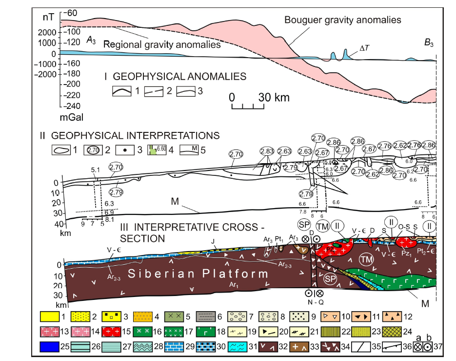
Fig.2 South Siberia-Central Mongolia transect, segment A3-B3 (see Fig.1; modified from Zorin et al.(1993)). I—Geophysical anomalies: 1—Bouguer gravity anomalies; 2—regional gravity anomalies; difference between 1 and 2 is decompensative gravity anomalies reflecting the upper-crust structure; 3—magnetic anomalies (ΔT). II—Geophysical cross section: 1—contours of bodies producing decompensative gravity anomalies; 2—weighted average densities; 3—gravity centers of magnetic bodies; 4—vertical seismic profiles (digits are P wave velocities); 5—Moho discontinuity. Ⅲ—Transect. Rock series of continental rifts (1, 2): 1—Late Cenozoic sediments with basaltic intercalations; 2—Jurassic to Early Cretaceous sediments with basaltic intercalations. Rock series of hot spots (3-5): 3—Early Jurassic bimodal volcanics intercalated with sediments; 4—Early Permian to Triassic alkaline granites; 5—Early Permian to Triassic alkaline basic intrusions. Rock series of orogenic basins (6-9): 6—Jurassic clastics of Siderian Platform margins; 7—Late Paleozoic molasse; 8—Middle Paleozoic molasse; 9—Early Paleozoic molasse. Rock series of magmatic arc, including island arc and active continental margins (10-17); 10—Late Paleozoic volcanic-sedimentary rocks; 11—Middle Paleozoic volcanic and volcanic-sedimentary rocks; 12—Early Paleozoic volcanic and volcanic-sedimentary rocks; 13—Late Paleozoic collision-related felsic intrusions; 14—Middle Paleozoic subduction- and collision-related felsic intrusions; 15—Early Paleozoic subduction- and collision-related felsic intrusions; 16—Late Paleozoic basic and intermediate intrusions; 17—Middle Paleozoic basic and intermediate intrusions; 18—Early Paleozoic basic and intermediate intrusions; 19—Late Paleozoic sediments infilling fore- and back-arc basins; 20—Middle Paleozoic chaotic complex of subduction-accretion wedge; 21—Middle Paleozoic sediments infilling back-arc basins. Ophiolites (22-25): 22—Late Paleozoic; 23—Middle Paleozoic; 24—Late Precambrian to Early Paleozoic; 25—fragments of oceanic crust of uncertain age. Ocean sediments (26-28): 26—Late Paleozoic; 27—Middle Paleozoic; 28—Late Precambrian to Early Paleozoic. Shelf sediments (29-31): 29—Ordovicican to Early Devonian; 30—Vendian to Cambrian; 31—Riphean to Cambrian. Precambrian continental crust (32-34): 32—uncertain in composition; 33—with significant role of granites; 34—with greenstone belts. Tectonic symbols (35-37): 35—normal faults and faults of uncertain geometry; 36—thrust faults; 37—wrench faults (right-lateral). SP—Siberian Platform; TM—Tuva-Mongolia microcontinent.
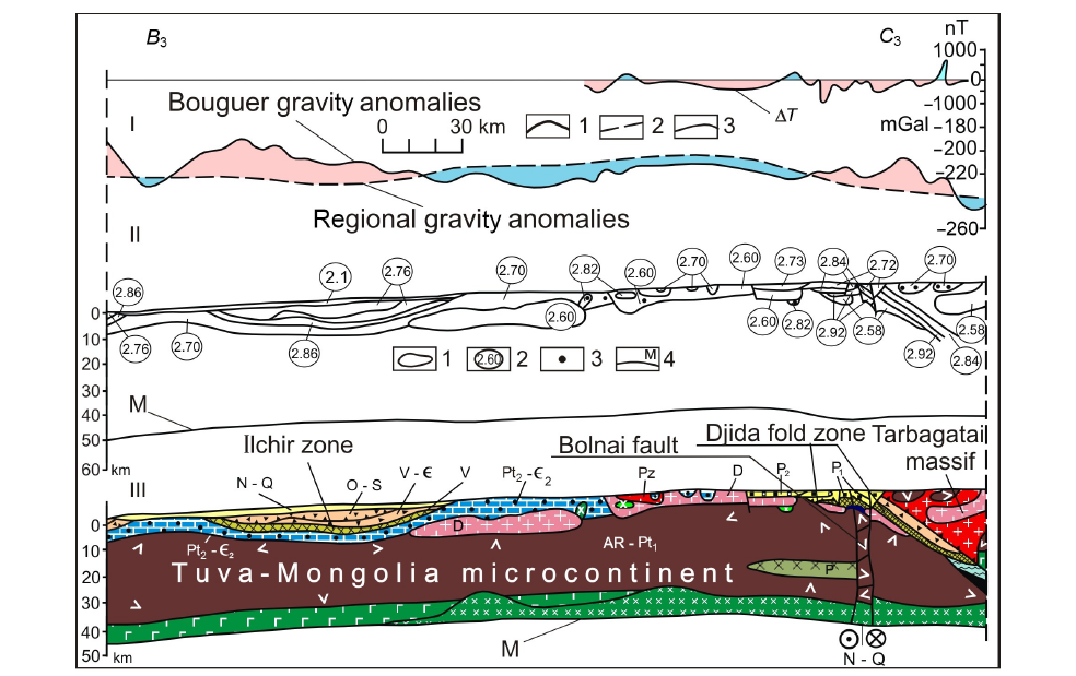
Fig.3 South Siberia-Central Mongolia transect, segment B3-C3 (see Fig.1; modified from Zorin et al.(1993)). For the legend, see Fig.2.
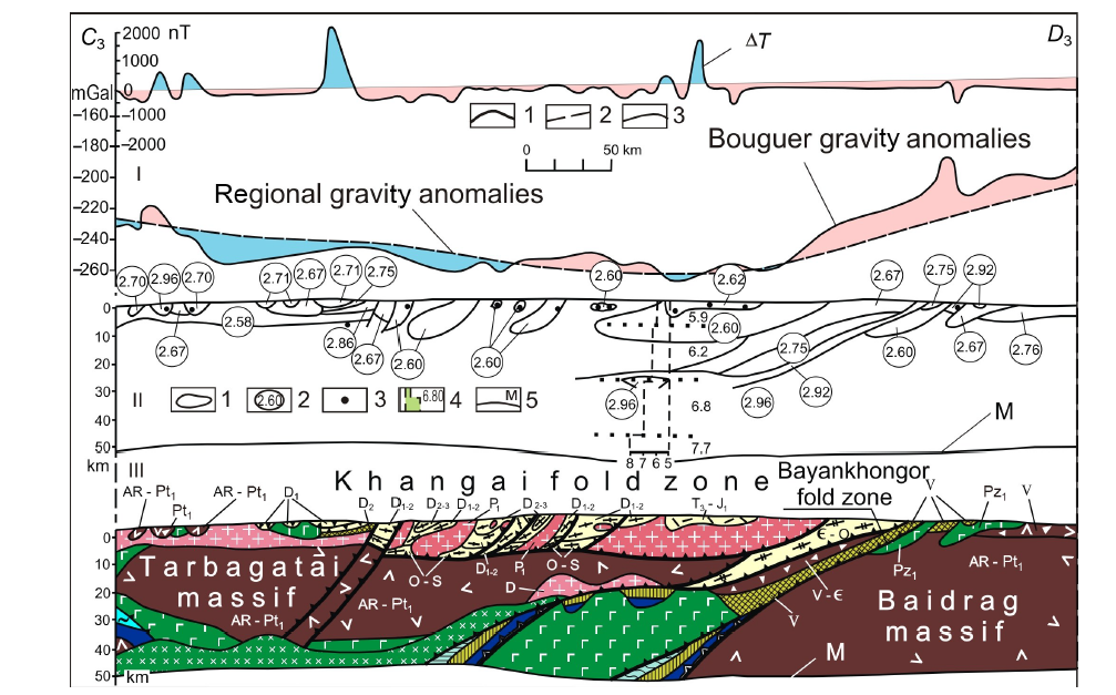
Fig.4 South Siberia-Central Mongolia transect, segment C3-D3 (see Fig.1; modified from Zorin et al.(1993)). For the legend, see Fig.2.
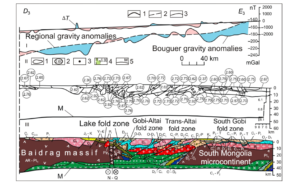
Fig.5 South Siberia-Central Mongolia transect, segment D3-E3 (see Fig.1; modified from Zorin et al.(1993)). For the legend, see Fig.2.

Fig.6 East Siberia transect, segment A1-B1 (see Fig.1; modified from Zorin et al.(1997a)). I—Geophysical anomalies: 1—Bouguer gravity anomalies; 2—regional gravity anomalies; difference between 1 and 2 is decompensative gravity anomalies reflecting the upper-crust structure; 3—magnetic anomalies (ΔT). II—Geophysical cross section: 1—contours of bodies producing decompensative gravity anomalies; 2—weighted average densities; 3—gravity centers of magnetic bodies; 4—vertical seismic profiles (digits are P wave velocities); 5—Moho discontinuity. Ⅲ—Transect. Rocks of continental rifts. Neogenic (Ng) (1, 2): 1—sediments; 2—basalts. Early Cretaceous (K1) (3, 4): 3—sediments; 4—volcanics. Collision-related rocks. Middle-Late Jurassic (5-7): 5—molasse (J2); 6—volcanics ( J 23); 7—granites & granodiorites ( J 23). Early Paleozoic (O-S): 8—granites & granodiorites. Rifean (Rif): 9—granites & granodiorites. Subduction-related rocks (magmatic arcs including subduction wedges, fore-and back-arc basins). Late Permian-Early Jurassic (P2-T & J1) (10-13): 10—marine sediments & volcanics; 11—continental sediments & volcanics; 12—granites & tonalites; 13—mafic intrusives. Late Carboniferous-Early Permian (C2-P1) (14-15): 14—granites & tonalites; 15—mafic intrusives. Devonian-Early Carboniferous (D-C1) (16-19): 16—marine sediments & volcanics; 17—continental sediments & volcanics; 18—granites & tonalites; 19—mafic intrusives. Vendian-Cambrian (V- C) & Vendian-Ordovician (V-O) (20-22): 20—sediments & volcanics; 21—tonalites & granodiorites; 22—mafic intrusives. Rifean (Rif) (23-25): 23—marine sediments & volcanics; 24—tonalites & granodiorites; 25—mafic intrusives. Platforms & microcontinents (26-33): 26—Early Jurassic (J1) passive continental margin; 27—Late Permian-Triassic (P2-T) passive continental margin; 28—Vendian-Ordovician (V-O) & Vendian-Cambrian (V- C) shelf; 29—Rifean (Rif) passive margin; 30—Rifean (Rif) shelf; 31—Early Precambrian (Pt1) crust with significant role of granites; 32—Early Precambrian (AR-Pt1) mainly tonalitic crust; 33—Early Precambrian crust with mafic rocks (AR-Pt1). Tectonic symbols (34-37): 34—normal faults & faults of uncertain geometry; 35—Middle Jurassic thrusts; 36—Ordovician-Silurian thrusts; 37—Rifean thrusts reactivated in Ordovician-Silurian.

Fig.7 East Siberia transect, segment B1-C1 (see Fig.1; modified from Zorin et al.(1997a)). For the legend, see Fig.6.
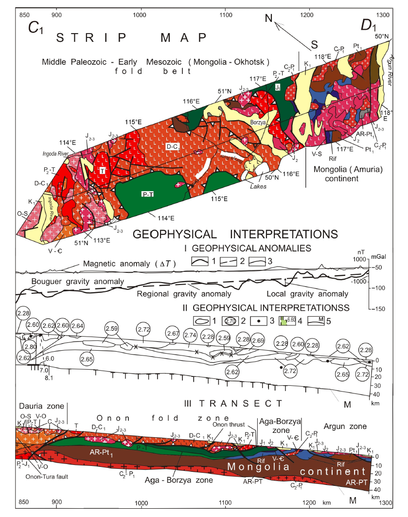
Fig.8 East Siberia transect, segment C1-D1 (see Fig.1; modified from Zorin et al.(1995, 1997b)). For the legend, see Fig.6.
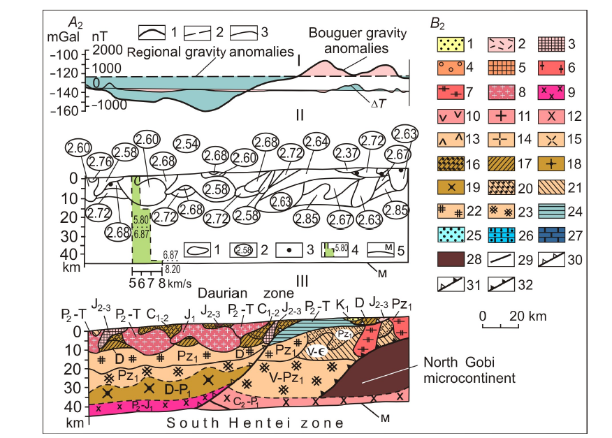
Fig.9 East Mongolia transect, segment A2-B2 (see Fig.1; modified from Zorin et al.(1998)). I—Geophysical anomalies: 1—Bouguer gravity anomalies; 2—regional gravity anomalies; difference between 1 and 2 is decompensative gravity anomalies reflecting the upper-crust structure; 3—magnetic anomalies (ΔT). II—Geophysical cross section: 1—contours of bodies producing decompensative gravity anomalies; 2—weighted average densities; 3—gravity centers of magnetic bodies; 4—vertical seismic profiles (digits are P wave velocities); 5—Moho discontinuity. Ⅲ—Transect. Early Cretaceous formation of continental rift: 1—sediments with effusive-body horizons. Collision-related rocks (2-7). Middle-Late Jurassic collision of Mongolo-China and Siberia (2, 3): 2—volcano-sedimentary sequences; 3—granitoids. Triassic collision of the Mongolian and North-Chinese continents (4, 5): 4—volcano-sedimentary and sedimentary sequences; 5—granitoids. Early Carboniferous collision of the North Gobi microcontinent with South Gobi island arc: 6—granitoids. Ordovician-Silurian collision of island arcs with the North Gobi microcontinent: 7—granitoids. Subduction formations (magmatic-arc series, including those of Andean-type active continental margins, island arcs, trenches, fore- and back-arc basins) (8-23). Late Permian-Early Jurassic subduction beneath the southern part of Siberia (8, 9): 8—granitoids; 9—mafic intrusive rocks. Late Carboniferous-Early Permian subduction beneath the northern part of Mongolia (10-12): 10—volcano-sedimentary sequences; 11—granitoids; 12—mafic intrusive rocks. Middle Carboniferous-Late Permian subduction beneath the southern part of Mongolia (13-15): 13—volcano-sedimentary sequences; 14—granitoids; 15—mafic intrusive rocks. Devonian-Early Permian subduction beneath Siberia, Devonian-Early Carboniferous subduction beneath the Central-Mongolia microcontinent, and Ordovician-Early Carboniferous subduction beneath the South Gobi island arc (16-19): 16—sedimentary sequences; 17—volcano-sedimentary sequences; 18—granitoids; 19—basic intrusive bodies. Vendian-Early Paleozoic subduction beneath the island arcs of the Paleoasian ocean (20-23): 20—sedimentary sequences; 21—volcano-sedimentary sequences; 22—granitoids; 23—mafic intrusive bodies. Formations of continents and microcontinents (24-28): 24—Late Permian-Triassic deposits of the northern passive margin of the Mongolia continent; 25—Late Permian continental deposits; 26—Devonian marine carbonates and clastic deposits; 27—Vendian-Early Paleozoic marine carbonates and clastic deposits; 28—pre-Riphean continental crust. Faults (29-32): 29—normal faults and faults of uncertain geometry; 30—Early Mesozoic thrusts; 31—Middle Paleozoic thrusts; 32—Early Paleozoic thrusts.

Fig.11 East Mongolia transect, segment C2-D2 (see Fig.1; modified from Zorin et al.(1998)). For the legend, see Fig.9.

Fig.10 East Mongolia transect, segment B2-C2 (see Fig.1; modified from Zorin et al.(1998)). For the legend, see Fig.9.
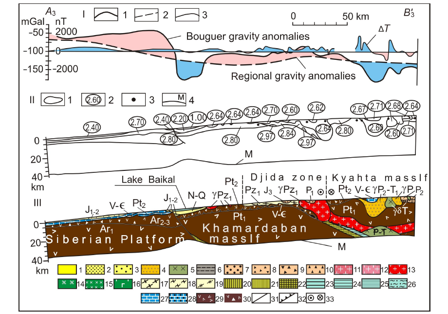
Fig.12 Baikal-Mongolia transect, segment A3-B'3 (see Fig.1; modified from Zorin et al.(1994)). I—Geophysical anomalies: 1—Bouguer gravity anomalies; 2—regional gravity anomalies; difference between 1 and 2 is decompensative gravity anomalies reflecting the upper-crust structure; 3—magnetic anomalies (ΔT). II—Geophysical cross section: 1—contours of bodies producing decompensative gravity anomalies; 2—weighted average densities; 3—gravity centers of magnetic bodies; 4—Moho discontinuity. Ⅲ—Transect. Formations of continental rifts and “hot spots” (1-5): 1—Late Cenozoic clastic deposits with interlayers of basalts; 2—Late Mesozoic clastic and volcanogenic-sedimentary deposits; 3—Late Paleozoic-Early Mesozoic volcanic rocks of the bimodal series with horizons of clastic deposits; 4—Late Paleozoic-Early Mesozoic alkaline granites and syenites; 5—main intrusions of the same age. Formations of foothill and intermountain subsidences of the orogenic stages (6, 7): 6—Jurassic continental deposits of the marginal part of the Siberian Platform; 7—Middle Paleozoic malasses. Formations of magmatic arcs (including island arcs and active margins of continents) (8-19): 8-10—volcanogenic and volcanogenic-sedimentary strata of the Late Paleozoic-Early Mesozoic (8), Middle Paleozoic (9) and Late Proterozoic-Early Paleozoic (10) stages; 11-13—granitoids of the Late Paleozoic-Early Mesozoic (11), Middle Paleozoic (12) and Late Proterozoic-Early Paleozoic (13) stages; 14-16—main and medium intrusions of the Late Paleozoic-Early Mesozoic (14), Middle Paleozoic (15) and Late Proterozoic-Early Paleozoic (16) stages; 17-19—sedimentary deposits of the pre- and back-arc troughs of the Late Paleozoic-Early Mesozoic (17), Middle Paleozoic (18) and Late Proterozoic-Early Paleozoic (19) stages. Oceanic formations (20-25): 20-22—ophiolites of the Late Paleozoic-Early Mesozoic (20), Middle Paleozoic (21) and Late Proterozoic-Early Paleozoic (22) stages; 23-25—deep-water sediments of the Late Paleozoic-Early Mesozoic (23), Middle Paleozoic (24) and Late Proterozoic-Early Paleozoic (25) stages. Offshore formations (26-28): 26—Middle Paleozoic shelf of the Paleotethys; 27—sedimentary cover of the Siberian Platform (Late Proterozoic-Early Paleozoic); 28—sedimentary cover of microcontinent (Late Proterozoic-Early Paleozoic). Precambrian continental crust of the platform and microcontinent (29, 30): 29—not dissected by composition; 30—with significant volumes of main rocks. Faults (31-33): 31—dip-slip faults dip and faults of an undetermined nature; 32—overthrusts; 33—faults (a left-side fault is indicated).

Fig.13 Baikal-Mongolia transect, segment B'3-C'3 (see Fig.1; modified from Zorin et al.(1994)). For the legend, see Fig.12.
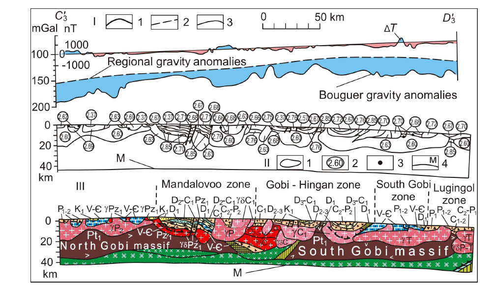
Fig.14 Baikal-Mongolia transect, segment C'3-D'3 (see Fig.1; modified from Zorin et al.(1994)). For the legend, see Fig.12.
| [1] | Argutina T A, Bulavko L F, Bulin N K, et al., 1974. Deep geological structure of the Transbaikalia[J]. Sovetskaya Geologia (1):103-117 (in Russian). |
| [2] | Belichenko V G, Shmotov A P, Sez’ko A I, et al., 1988. Precambrian and Paleozoic evolution of Earth crust (Sayan-Baikal Mountain region)[M]. Novosibirsk: Nauka: 161 (in Russian). |
| [3] | Berzin N A, Dobretsov N L, 1993. Geodynamic evolution of Siberia in Late Precambrian - Early Paleozoic time: reconstruction of the Paleo-Asian ocean[M]. Amsterdam: VSR International Science Pubishers: 45-62. |
| [4] |
Cordell L, Zorin Y A, Keller R, 1991. The decompensative gravity anomaly and deepstructure of the region of the Rio Grande rift[J]. Journal of Geophysical Research, 96(B4):6557-6558.
DOI URL |
| [5] | Dergunov A B, 1989. Caledonides of Central Asia[M]. Moscow: [s.n.]: 191 (in Russian). |
| [6] | Didenko A N, Mossakovskii A A, Pecherskii D M, et al., 1994. Geodynamics of the Paleozoic oceans of the Central Asia[J]. Geologia i Geofizika (7/8):59-75 (in Russian). |
| [7] | Dortman N B, 1984. Physical properties of rocks and mineral resources[M]. Moscow: [s.n.]: 445 (in Russian). |
| [8] | Egorkin A V, Chernikov N M, Danilova Y G, et al., 1980. A regional profile across the northern Asian continent[M]//Zverev S M, Kosminskaya I P. Seismic models of the lithosphere of major geological units on the USSR Territory. Moscow:Nauka:61-67 (in Russian). |
| [9] | Filippova I B, 1969. The Khangay synclinorium: main features of structure and evolution[J]. Geotektonika(5):76-78 (in Russian). |
| [10] | Korostin P V, 1968. Magnetic field of the Baikal area and an essay of its geological interpretation[M]//Belousov V V, Florensov N A. Baikal rift. Moscow: Nauka:131-139 (in Russian). |
| [11] | Kovalenko V I, Yarmoliuk V V, 1990. Evolution of magmatism in geological structures of Mongolia[M]//Zaitsev N S, Kovalenko V I. Evolution of geological processes. Moscow: [s.n.]: 23-55 (in Russian). |
| [12] | Kozhevnikov V M, Antonova L M, Yanovskaya T B, 1990. Horizontal inhomogeneities of the crust and upper mantle beneath the Asian continent according to the data on the surface Rayleigh waves[J]. Izv AN SSSR, Fizika Zemli (3):3-11 (in Russian). |
| [13] | Krylov S V, Mishen’kin B P, Bryksin A V, 1990a. Deep structure of the Baikal rift zone according to the data of multi-waves seismic investigations[M]//Geodynamics of the intracontinental mountainous regions. Novosibirsk:Nauka: 162-169 (in Russian). |
| [14] | Krylov S V, Mandelbaum M M, Seleznev V S, et al., 1990b. Detail deep seismic studies in the Upper Angara area of the Baikal rift zone[J]. Geologia i Geofizika (7):17-27 (in Russian). |
| [15] | Kuznetzov V G, Khrenov P M, 1982. Geological map of Irkutsk region, scale 1∶500000[CM]. Leningrad: VSEGEI: 10 (in Russian). |
| [16] | Mordvinova V V, Zorin Y A, Gao S, et al., 1995. Estimations of the Earth’s crust thickness on the profile Irkutsk-Ulan-Baator-Undurshil according to the spectral ratios of the body seismic waves[J]. Fizika Zemli (9):3-11 (in Russian). |
| [17] | Novoselova M R, 1978. Magnetic anomalies of the Baikal rift zone and adjacent areas[J]. Tectonophysics, 46(1):95-100. |
| [18] | Phinney R A, 1964. Structure of the Earth’s crust from spectral behavior of long-period body waves[J]. Jurnal of Geophysical Research, 69(14):2997-3017. |
| [19] | Pis’mennyi B M, Alakshin A M, Poepeev A V, et al., 1984. Geology and seismicity of the BAM zone[M]. Novosibirsk: Nauka: 172 (in Russian). |
| [20] | Puzyrev N N, 1981. The interior of Baikal from seismic data[M]. Novosibirsk: Nauka: 105 (in Russian). |
| [21] | Rutstein I G, 1992. Geological map of the Chita region, scale 1∶500000[CM]. Moscow: MPGIT: 23. |
| [22] | Ruzhentsev S V, Badarch G, Voznesenskaya T A, 1985. Tectonics of Trans-Altai zone of Mongolia[J]. Geotectonics, 19(4):276-284 (in Russian). |
| [23] | Ruzhentsev S V, Mossakovskiy A A, 1996. Geodynamics and tectonic evolution of the central segments of the Earth[J]. Geotectonics, 29(4):211-311. |
| [24] | Shobogorov P C, 1977. Geological map of Bouriatia, scale 1∶500000[CM]. Leningrad: VSEGEI: 9 (in Russian). |
| [25] | Stepanov P P, Volkhonin V S, 1969. The present-day deep structure of the crust in Mongolia, from geophysical evidence[J]. Sovetskaya Geologia (5):47-63 (in Russian). |
| [26] | Tsyrendorzhiev T T, 1963. Elements of tectonics of the Baikal area, from geophysical data[J]. Geologia and Geofizika (6):60-67 (in Russian). |
| [27] |
Vinnik L P, 1977. Detection of waves converted from P to S in the mantle[J]. Physics of the Earth and Planetary Interiors, 15:39-45.
DOI URL |
| [28] | Zamaraev S M, 1967. Marginal features of the southern Siberian Platform[M]. Moscow: Nauka: 248 (in Russian). |
| [29] | Zonenshain L P, Kus’min M I, Natapov L M, 1990. Tectonics of the lithosphere plates in the USSR area[M]. [S.l.]: Nauka: 326 (in Russian). |
| [30] | Zorin Y A, 1967. On tectonics of the Eastern and Central Trans-Baikal area in the Late Mesozoic[J]. Geotectonika (1):97-108 (in Russian). |
| [31] | Zorin Y A, 1971. The newest structure and isostasy of the Baikal rift zone and adjacent areas[M]. Moscow: Nauka: 168 (in Russian). |
| [32] | Zorin Y A, Novoselova M P, Rogozhina V A, 1982. Deep structure of the Mongolia[M]. Novosibirsk: Nauka: 93 (in Russian). |
| [33] | Zorin Y A, Pis’mennui B M, Novoselova M P, et al., 1985. Decompensative gravity anomalies[J]. Geologiya i Geofizika (8):104-108 (in Russian). |
| [34] | Zorin Y A, Mordvinova V V, Novoselova M P, et al., 1986. Density inhomogeneity of the mantle beneath the Baikal rift[J]. Izv AN SSSR Fizika Zemli (5):43-52 (in Russian). |
| [35] |
Zorin Y A, Kozhevnikov V M, Novoselova M R, et al., 1989. Thickness of the lithosphere beneath the Baikal zone and adjacent regions[J]. Tectonophysics, 168:327-337.
DOI URL |
| [36] |
Zorin Y A, Novoselova M R, Turutanov E K, et al., 1990. Structure of the lithosphere in the Mongolia-Siberian mountainous province[J]. Journal of Geodynamics, 11:327-342.
DOI URL |
| [37] |
Zorin Y A, Belichenko V G, Turutanov E K, et al., 1993. The South Siberia - Central Mongolia transect[J]. Tectonophysics, 225:361-378.
DOI URL |
| [38] | Zorin Y A, Belichenko V G, Turutanov E K, et al., 1994. Baikal-Mongolian transect[J]. Geologia i Geofizika (7/8):94-110 (in Russian). |
| [39] |
Zorin Y A, Belichenko V G, Turutanov E K, et al., 1995. The East Siberia transect[J]. International Geology Review, 37(2):154-175.
DOI URL |
| [40] | Zorin Y A, Belichenko V G, Logachev N A, et al., 1996. Paleogeodynamics of the central Asia[M]//Lithosphere of the central Asia. Novosibirsk:Nauka:9-16 (in Russian). |
| [41] | Zorin Y A, Belichenko V G, Turutanov E K, et al., 1997a. Earth’s crust structure and geodynamics of the Baikal fold area[J]. Otechestvennaya Geologiya (10):37-44 (in Russian). |
| [42] | Zorin Y A, Belichenko V G, Turutanov E K, et al., 1997b. Earth’s crust structure and geodynamics of the western part of Mongolia-Okhotsk belt[J]. Otechestvennaya Geologia (11):52-58 (in Russian). |
| [43] | Zorin Y A, Belichenko V G, Turutanov E K, et al., 1998. The terreins of the Eastern Mongolia and Central Transbaikalia and evolution of Mongolo-Okhotsk fold beld[J]. Geologiya i Geofisika, 39(1):11-25 (in Russian). |
| [44] |
Zorin Y A, Mordvinova V V, Turutanov E K, et al., 2002. Low seismic velocity layers in the Earth’s crust beneath Eastern Siberia (Russia) and Central Mongolia: receiver function data and their possible geological implication[J]. Tectonophysics, 359:307-327.
DOI URL |
| [45] | Zorin Y A, Turutanov E K, Mordvinova V V, et al., 2004. Complex geophysical and seismological investigations in Mongolia[M]. Ulanbaatar-Irkutsk: Institute of Earth Crust SD Russian AS: 33-50. |
| [46] | Zverev S M, Kos’minskaya I P, 1980. Seismic models of the main geostructures of the USSR[M]. Moscow: Nauka: 183 (in Russian). |
| [1] | 杨文采. 固体地球物理学与板块大地构造学的交汇[J]. 地学前缘, 20140101, 21(1): 89-99. |
| [2] | 翟明国, 胡波, 彭澎, 赵太平. 华北中—新元古代的岩浆作用与多期裂谷事件[J]. 地学前缘, 20140101, 21(1): 100-119. |
| [3] | 万天丰. 论构造地质学和大地构造学的几个重要问题[J]. 地学前缘, 20140101, 21(1): 132-149. |
| [4] | 孙志文, 贾永刚, 权永峥, 郭秀军, 刘涛, 孟庆生, 孙中强, 李凯, 范智涵, 陈天, 唐浩儒. 复杂深海工程地质原位长期监测系统研发与应用[J]. 地学前缘, 2022, 29(5): 216-228. |
| [5] | 陈天, 贾永刚, 刘涛, 刘晓磊, 单红仙, 孙中强. 海底沉积物孔隙压力原位长期观测技术回顾和展望[J]. 地学前缘, 2022, 29(5): 229-245. |
| [6] | 夏学齐, 季峻峰, 杨忠芳, 卢新哲, 黄春雷, 魏迎春, 徐常艳, 梁卓颖. 母岩类型对土壤和沉积物镉背景的控制: 以贵州为例[J]. 地学前缘, 2022, 29(4): 438-447. |
| [7] | 文冬光, 宋健, 刁玉杰, 张林友, 张福存, 张森琦, 叶成明, 朱庆俊, 史彦新, 金显鹏, 贾小丰, 李胜涛, 刘东林, 王新峰, 杨骊, 马鑫, 吴海东, 赵学亮, 郝文杰. 深部水文地质研究的机遇与挑战[J]. 地学前缘, 2022, 29(3): 11-24. |
| [8] | 崔显岳, 陈柏林, 司晓博, 邓晋福, 冯艳芳, 肖庆辉. 长乐—南澳构造带泉港临头片麻状英云闪长岩中岩浆绿帘石的发现及其地质意义[J]. 地学前缘, 2022, 29(2): 234-240. |
| [9] | 侯方辉, 朱晓青, 张训华, 吴志强, 郭兴伟, 祁江豪, 温珍河, 王保军, 孟祥君. 中国东部海域地质特征及一些重要大地构造界线在海区延伸的地质地球物理证据[J]. 地学前缘, 2022, 29(2): 281-293. |
| [10] | 金铭, 丁孝忠, 韩坤英, 刘建忠, 凌宗成, 许可娟, 庞健峰, 邵天瑞. 月球地质图空间数据库设计[J]. 地学前缘, 2022, 29(2): 343-353. |
| [11] | 许可娟, 丁孝忠, 韩坤英, 刘敬稳, 凌宗成, 庞健峰, 王颖. 月球佩塔维厄斯幅(LQ-21)数字地质填图与区域地质演化特征[J]. 地学前缘, 2022, 29(2): 354-369. |
| [12] | 冯艳芳, 刘江涛, 刘勇, 崔显岳, 司晓博. 国内外基础地质数据更新现状与思考[J]. 地学前缘, 2022, 29(2): 370-377. |
| [13] | Valentina V. MORDVINOVA, Maria A. KHRITOVA, Elena A. KOBELEVA, Mikhail M. KOBELEV, Evgeniy Kh. TURUTANOV, Victor S. KANAYKIN. 远震数据显示贝加尔裂谷带北穆伊斯克(Severomuysk)段地壳和上地幔的精细结构[J]. 地学前缘, 2022, 29(2): 378-392. |
| [14] | 刘勇, 李廷栋, 肖庆辉, 张克信, 朱小辉, 丁孝忠. 洋板块地质研究进展[J]. 地学前缘, 2022, 29(2): 79-93. |
| [15] | 杨晓平, 钟辉, 杨雅军, 江斌, 钱程, 马永非, 张超. 大兴安岭地区古生代构造格架重建:来自俯冲增生杂岩研究进展[J]. 地学前缘, 2022, 29(2): 94-114. |
| 阅读次数 | ||||||
|
全文 |
|
|||||
|
摘要 |
|
|||||