地学前缘 ›› 2021, Vol. 28 ›› Issue (2): 35-45.DOI: 10.13745/j.esf.sf.2020.9.18
王萍1( ), 王慧颖1, 胡钢1, 覃金堂1, 李翠平2
收稿日期:2020-06-30
修回日期:2020-07-20
出版日期:2021-03-25
发布日期:2021-04-03
作者简介:王 萍(1964—),女,博士,研究员,主要从事构造地貌与年代学研究。E-mail: wangping@ies.ac.cn
基金资助:
WANG Ping1(), WANG Huiying1, HU Gang1, QIN Jintang1, LI Cuiping2
Received:2020-06-30
Revised:2020-07-20
Online:2021-03-25
Published:2021-04-03
摘要:
展布于青藏高原东南部的雅鲁藏布江流域河谷中广泛分布有古堰塞湖沉积,古堰塞湖发育与构造活动、气候变化和地表过程等因素关系密切。在广泛地质调查的基础上,识别出雅鲁藏布江流域的十余个古堰塞湖,通过对其开展沉积学、地貌学和年代学工作,结合前人工作结果,初步建立了古堰塞湖群的地层年代框架。地表残留的古堰塞湖沉积多集中于末次冰期冰盛期和全新世早期,持续时间可达千年—万年。对大竹卡古湖、格嘎古湖和易贡湖的研究结果进行了介绍,归纳出古堰塞湖群发育的基本特征,初步讨论了构造、气候和侵蚀相互作用下古堰塞湖研究的意义、存在的问题以及研究的方向。提出末次冰期以来的冰川(泥石流)堵江-堰塞-溃决洪水所构建的极端气候-灾害事件,对雅鲁藏布江河谷地貌和古地理环境等有重要影响。
中图分类号:
王萍, 王慧颖, 胡钢, 覃金堂, 李翠平. 雅鲁藏布江流域古堰塞湖群的发育及其地质意义初探[J]. 地学前缘, 2021, 28(2): 35-45.
WANG Ping, WANG Huiying, HU Gang, QIN Jintang, LI Cuiping. A preliminary study on the development of dammed paleolakes in the Yarlung Tsangpo River basin, southeastern Tibet[J]. Earth Science Frontiers, 2021, 28(2): 35-45.
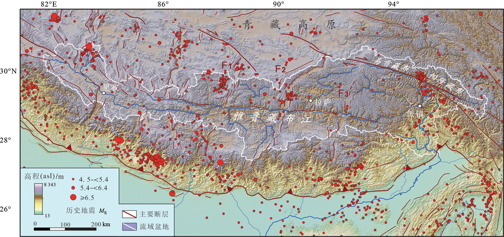
图1 雅鲁藏布江流域地理位置及地震构造简图(断层据文献[29]修改)
Fig.1 A simplified tectonic map showing the geographic location, principal faults and historic earthquake events in the Yarlung Tsangpo River basin. Modified after [29].
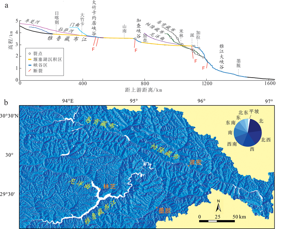
图2 雅鲁藏布江中、下游流域河谷形貌(基于SRTM NASA DEM 30 m分辨率的DEM数据获得) a—雅鲁藏布江中下游及主要支流的河流纵剖面;b—雅鲁藏布江大拐弯地区坡向分布图。
Fig.2 DEM map based on 30-meter SRTM data released by NASA, showing the valley morphology in the middle and lower reaches of the Yarlung Tsangpo River

图3 雅鲁藏布江中下游古堰塞湖群的分布 ZY—忠玉古湖;TL—塔鲁古湖;GX—古乡古湖;SZ—松宗古湖;YP—玉普古湖;DJ—东久古湖;LL—鲁朗古湖。
Fig.3 Distribution of dammed paleolakes in the middle and lower reaches of the Yarlung Tsangpo River

图4 大竹卡古堰塞湖及堰塞坝 a—古堰塞湖沉积及湖岸线的展布(插图a’显示基岩岸坡与古堰塞湖及上覆黄土-古土壤沉积的交界位置);b—位于约居峡谷出口的残留冰川泥石流堰塞坝(箭头指向残余坝体的最高处,镜头北西)。
Fig.4 Photos of the Dazhuka dammed paleolake and dams

图5 格嘎古堰塞湖沉积与地貌 a—两期古湖沉积范围;b—湖积阶地;c—开挖剖面揭示的两期古堰塞湖沉积;d—T1阶地剖面;e—T2阶地剖面。照片显示两个沉积旋回的岩性变化,下部红色砂层为下旋回的顶部沉积,上部灰色黏土层为上旋回的底部沉积。
Fig.5 Sedimentary and geomorphologic features of the Gaga paleolakes

图6 古堰塞湖沉积中记录到的古地震变形构造 a—底部液化砂层向上穿刺湖相地层形成砂脉及角砾;b—包卷构造。
Fig.6 Paleoseismic deformation structure recorded in the sediments of dammed paleolake

图7 雅鲁藏布江-布拉马普特拉河的环境考古调查 红色方框为14C年龄,红色圆点为OSL年龄。a—尼洋曲左岸立定村发现的古人遗骸;b—孟加拉国Wari-Bateshwar遗址。
Fig.7 Environmental archaeological investigation of the Yarlung Tsangpo-Brahmaputra River
| [1] |
BURBANK D W, BLYTHE A E, PUTKONEN J, et al. Decoupling of erosion and precipitation in the Himalayas[J]. Nature, 2003,426(6967):652-655.
DOI URL |
| [2] |
OUIMET W B, WHIPPLE K X, ROYDEN L H, et al. The influence of large landslides on river incision in a transient landscape: eastern margin of the Tibetan Plateau (Sichuan, China)[J]. Bulletin of the Geological Society of America, 2007,119(11/12):1462-1476.
DOI URL |
| [3] |
FINNEGAN N J, HALLET B, MONTGOMERY D R, et al. Coupling of rock uplift and river incision in the Namche Barwa-Gyala Peri massif, Tibet[J]. Geological Society of America Bulletin, 2008,120(1/2):142-155.
DOI URL |
| [4] |
KORUP O, MONTGOMERY D R. Tibetan Plateau river incision inhibited by glacial stabilization of the Tsangpo Gorge[J]. Nature, 2008,455(7214):786-789.
DOI URL |
| [5] |
WANG P, SCHERLER D, LIU Z J, et al. Tectonic control of Yarlung Tsangpo Gorge revealed by a buried canyon in southern Tibet[J]. Science, 2014,346(6212):978-981.
DOI URL |
| [6] | 王兆印, 余国安, 王旭昭, 等. 青藏高原抬升对雅鲁藏布江泥沙运动和地貌演变的影响[J]. 泥沙研究, 2014(2):1-7. |
| [7] |
TU J Y, JI J Q, SUN D X, et al. Thermal structure, rock exhumation, and glacial erosion of the Namche Barwa Peak, constraints from thermo chronological data[J]. Journal of Asian Earth Sciences, 2015,105:223-233.
DOI URL |
| [8] |
BRACCIALI L, PARRISH RR, NAJMAN Y, et al. Plio-Pleistocene exhumation of the eastern Himalayan syntaxis and its domal‘pop-up’[J]. Earth-Science Reviews, 2016,160:350-385.
DOI URL |
| [9] | 杨逸畴, 高登义, 李渤生. 雅鲁藏布江下游河谷水汽通道初探[J]. 中国科学: B辑, 1987,17(8):893-902. |
| [10] |
MONTGOMERY D R, HALLET B, YUPING L, et al. Evidence for Holocene megafloods down the Tsangpo River Gorge, southeastern Tibet[J]. Quaternary Research, 2004,62(2):201-207.
DOI URL |
| [11] | 胡敬仁, 孙中良, 陈国结, 等. 日喀则市幅地质调查新成果及主要进展[J]. 地质通报, 2004,23(增刊):463-470. |
| [12] | 曾庆利, 杨志法, 袁广祥, 等. 松宗古湖—藏东南帕隆藏布江末次盛冰期发育的一个冰川堰塞湖[J]. 第四纪研究, 2007,27(1):85-92. |
| [13] |
KAISER K, LAI Z P, SCHNEIDER B, et al. Late Pleistocene genesis of the middle Yarlung Zhangbo valley, southern Tibet (China), as deduced by sedimentological and luminescence data[J]. Quaternary Geochronology, 2010,5(2/3):200-204.
DOI URL |
| [14] |
ZHU S, WU Z H, ZHAO X T, et al. Middle-late Pleistocene Glacial Lakes in the Grand Canyon of the Tsangpo River, Tibet[J]. Acta Geologica Sinica, 2012,86(1):266-283.
DOI URL |
| [15] |
ZHU S, WU Z H, ZHAO X T, et al. Glacial dammed lakes in the Tsangpo River during late Pleistocene, southeastern Tibet[J]. Quaternary International, 2013,298(17):114-122.
DOI URL |
| [16] |
HUANG S Y, CHEN Y G, BURR G S, et al. Late Pleistocene sedimentary history of multiple glacially dammed lake episodes along the Yarlung-Tsangpo River, southeast Tibet[J]. Quaternary Research, 2014,82(2):430-440.
DOI URL |
| [17] | 李翠平, 王萍, 钱达, 等. 雅鲁藏布江大峡谷入口河段最近两期古堰塞湖事件的年龄[J]. 地震地质, 2015,37(4):1136-1146. |
| [18] |
LIU W M, LAI Z P, HU K H, et al. Age and extent of a giant glacial-dammed lake at YarlungTsangpo gorge in the Tibetan Plateau[J]. Geomorphology, 2015,246(1):370-376.
DOI URL |
| [19] |
HUANG L, ZHU L P, WANG J B, et al. Glacial Activity reflected in a continuous lacustrine record since the early Holocene from theproglacial Laigu Lake on the southeastern Tibetan Plateau[J]. Palaeogeography, Palaeoclimatology, Palaeoecology, 2016,456(15):37-45.
DOI URL |
| [20] | 韩建恩, 孟庆伟, 郭长宝, 等. 雅鲁藏布江中游杰德秀古湖的发现及其意义[J]. 现代地质, 2017,31(5):890-899. |
| [21] |
HU H P, FENG J L, CHEN F. Sedimentary records of a palaeo-lake in the middle Yarlung Tsangpo: implications for terrace genesis and outburst flooding[J]. Quaternary Science Reviews, 2018,192(15):135-148.
DOI URL |
| [22] |
WANG H, CUI P, LIU D Z, et al. Evolution of a landslide-dammed lake on the southeastern Tibetan Plateau and its influence on river longitudinal profiles[J]. Geomorphology, 2019,343:15-32.
DOI URL |
| [23] |
TURZEWSKI M D, HUNTINGTON K W, LICHT A, et al. Provenance and erosional impact of Quaternary megafloods through the Yarlung-Tsangpo Gorge from zircon U-Pb geochronology of flood deposits, eastern Himalaya[J]. Earth and Planetary Science Letters, 2020,535:116113.
DOI URL |
| [24] |
XU Q Q, JI J Q, ZHONG D L, et al. Post-glacial entrenchment and knickpoint Migration of the Yarlung Tsangpo Gorge, southeastern Tibetan Plateau[J]. Journal of Asian Earth Sciences, 2020,195(15):104337.
DOI URL |
| [25] | KORUP O, MONTGOMERY D R, HEWITT K. Glacier and landslide feedbacks to topographic relief in the Himalayan syntaxes[J]. Proceedings of the National Academy of Sciences of the United States of America, 2010,107(12):5317-5322. |
| [26] |
LARSEN I J, MONTGOMERY D R. Landslide erosion coupled to tectonics and river incision[J]. Nature Geoscience, 2012,5(7):468-473.
DOI URL |
| [27] |
LANG K A, HUNTINGTON K W, MONTGOMERY D R. Erosion of the Tsangpo Gorge by megafloods, eastern Himalaya[J]. Geology, 2013,41(9):1003-1006.
DOI URL |
| [28] | 崔鹏, 陈容, 向灵芝, 等. 气候变暖背景下青藏高原山地灾害及其风险分析[J]. 气候变化研究进展, 2014,10(2):103-109. |
| [29] |
TAPPONNIER P, ZHIQIN X, ROGER F, et al. Oblique stepwise rise and growth of the Tibet Plateau[J]. Science, 2001,294(5547):1671-1677.
DOI URL |
| [30] | 孙杰. 基于DEM的青藏高原河流地貌量化分析: 以雅鲁藏布江和朋曲为例[D]. 北京: 中国科学院, 2009. |
| [31] | 杜国梁. 喜马拉雅东构造结地区滑坡发育特征及危险性评价[D]. 北京: 中国地质科学院, 2017. |
| [32] | 杨逸畴. 雅鲁藏布江大拐弯峡谷的地貌特征和成因[J]. 地理研究, 1982, 1(1): 40-48, 111-114. |
| [33] |
LIU W M, CARLING P A, HU K H, et al. Outburst floods in China: a review[J]. Earth-Science Reviews, 2019,197:102895.
DOI URL |
| [34] | 张沛全, 刘小汉, 孔屏. 雅鲁藏布江大拐弯地区末次冰期以来的冰川活动证据及其构造: 环境意义[J]. 地质科学, 2008,43(3):588-602. |
| [35] |
HANSON M A, LIAN O B, CLAGUE J J. The sequence and timing of large late Pleistocene Floods from glacial Lake Missoula[J]. Quaternary Science Reviews, 2012,31:67-81.
DOI URL |
| [36] |
SCHERLER D, MUNACK H, MEY J, et al. Ice dams, outburst floods, and glacial incision at the western margin of the Tibetan Plateau: a>100 k.y. chronology from the Shyok Valley, Karakoram[J]. Geological Society of America Bulletin, 2014,126(5/6):738-758.
DOI URL |
| [37] |
BORGOHAIN B, MATHEW G, CHAUHAN N, et al. Evidence of episodically accelerated denudation on the TibetanNamche Barwa massif by megafloods[J]. Quaternary Science Reviews, 2020,245:106410.
DOI URL |
| [38] | 刘国权, 鲁修元. 西藏易贡藏布扎木弄沟特大型山体崩塌滑坡、泥石流成因分析[J]. 西藏科技, 2000(4):15-17. |
| [39] |
SHANG Y J, YANG Z F, LI L H, et al. A super-large landslide in Tibet in 2000: background, occurrence, disaster, and origin[J]. Geomorphology, 2003,54(3/4):225-243.
DOI URL |
| [40] | 殷跃平. 西藏波密易贡高速巨型滑坡特征及减灾研究[J]. 水文地质工程地质, 2000,27(4):8-11. |
| [41] | 李俊, 陈宁生, 刘美, 等. 2000年易贡乡扎木弄沟滑坡型泥石流主控因素分析[J]. 南水北调与水利科技, 2018,16(6):187-193. |
| [42] | 刘宇平, MONTGOMERY D R, HALLET B, 等. 西藏东南雅鲁藏布大峡谷入口处第四纪多次冰川阻江事件[J]. 第四纪研究, 2006,26(1):52-62. |
| [43] | 陈建军, 季建清, 龚俊峰, 等. 雅鲁藏布江大峡谷的形成[J]. 地质通报, 2008,27(4):491-499. |
| [44] |
HOU J Z, D’ANDREA W J, D’ANDREA W J . The influence of 14C reservoir age on interpretation of paleolimnological records from the Tibetan Plateau[J]. Quaternary Science Reviews, 2012,48(10):67-79.
DOI URL |
| [45] | 王宗礼, 何建华, 陈亚东. 湖泊碳库效应及校正方法[J]. 中国沙漠, 2014,34(3):683-688. |
| [46] |
HU G, YI C L, ZHANG J F, et al. Chronology of a lacustrine core from Lake Linggo Co using a combination of OSL, 14C and 210Pb dating: implications for the dating of lacustrine sediments from the Tibetan Plateau[J]. Boreas, 2018,47(2):656-670.
DOI URL |
| [47] |
ALEXANDERSON H, MURRAY A S. Problems and potential of OSL dating Weichselian and Holocene sediments in Sweden[J]. Quaternary Science Reviews, 2012,44:37-50.
DOI URL |
| [48] |
HU G, YI C L, ZHANG J F, et al. Luminescence dating of glacial deposits near the eastern Himalayan syntaxis using different grain-size fractions[J]. Quaternary Science Reviews, 2015,124:124-144.
DOI URL |
| [49] | 丁林, 钟大赉, 潘裕生, 等. 东喜马拉雅构造结上新世以来快速抬升的裂变径迹证据[J]. 科学通报, 1995,40(16):1497-1500. |
| [50] |
BURG J P, NIEVERGELT P, OBERLI F, et al. The Namche Barwasyntaxis: evidence for exhumation related to compressional crustal folding[J]. Journal of Asian Earth Sciences, 1998,16(2/3):239-252.
DOI URL |
| [51] | 张进江, 季建清, 钟大赉, 等. 东喜马拉雅南迦巴瓦构造结的构造格局及形成过程探讨[J]. 中国科学: D辑, 2003,33(4):373-383. |
| [52] | 季建清, 钟大赉, 丁林, 等. 雅鲁藏布大峡谷地质成因[J]. 地学前缘, 1999,6(4):231-235. |
| [53] |
ZEITLER P K, KOONS P O, BISHOP M P, et al. Crustal reworking at Nanga Parbat, Pakistan: metamorphic consequences of thermal-mechanical coupling facilitated by erosion[J]. Tectonics, 2001,20(5):712-728.
DOI URL |
| [54] | ZEITLER P K, MELTZER A S, BROWN L, et al. Tectonics and topographic evolution of Namche Barwa and the easternmost Lhasa block, Tibet[M]//NIE J, HORTON B K, HOKE G D. Toward and improved understanding of uplift mechanism and elevation history of the Tibetan Plateau. Colorado: The Geological Society of America, 2014: 23-58. |
| [55] |
KOONS P O, ZEITLER P K, CHAMBERLAIN C P, et al. Mechanical links between erosion and metamorphism in Nanga Parbat, Pakistan Himalaya[J]. American Journal of Science, 2002,302(9):749-773.
DOI URL |
| [56] |
HU G, WANG P, LI D H, et al. Landscape change and its influence on human activities in Lhasa Basin of central Tibetan Plateau since the last deglacial[J]. Quaternary International, 2020,536, 1-12.
DOI URL |
| [57] | 张文敬. 南迦巴瓦峰跃动冰川的某些特征[J]. 山地研究, 1985,3(4):234-238. |
| [58] | BUREAUZ M. Will find out why the ‘sacred’ Brahmaputra is turning black: KirenRijiju[N/OL]. [2017-12-08]. https://zeenews.india.com/india/brahmaputra-is-our-sacred-river-will-find-out-why-its-turning-black-rijiju-2064108.html. |
| [59] |
SCOTT B, PRICE S. Earthquake-induced structures in young sediments[J]. Tectonophysics, 1988,147(1/2):165-170.
DOI URL |
| [60] |
NEUWERTH R, SUTER F, GUZMAN C A, et al. Soft-sediment deformation in a tectonically active area: the Plio-Pleistocene Zarzal formation in the Cauca Valley (western Colombia)[J]. Sedimentary Geology, 2006,186(1/2):67-88.
DOI URL |
| [61] |
WANG H, LI K, CHEN L, et al. Evidence for Holocene activity on the Jiali fault, an active block boundary in the southeastern Tibetan Plateau[J]. Seismological Research Letters, 2020,91(3):1776-1780.
DOI URL |
| [62] | 邢爱国, 徐娜娜, 宋新远. 易贡滑坡堰塞湖溃坝洪水分析[J]. 工程地质学报, 2010,18(1):78-83. |
| [63] |
HU G, WANG P, RAHMAN S M, et al. Vicissitudes experienced by the oldest urban center in Bangladesh in relation to the migration of the Brahmaputra River[J]. Journal of Quaternary Science, 2020. DOI: 10.1002/jqs.3240.
DOI |
| [1] | Mikhail M. BUSLOV, Lyudmila P. IMAEVA. 阿尔泰—萨彦山的新构造运动和区域控震断裂的再活化[J]. 地学前缘, 2021, 28(5): 301-319. |
| [2] | 刘维明, 周丽琴, 陈晓清, 周震, Wolfgang SCHWANGHART, 胡旭东, 李雪梅, 张小刚. 雅砻江流域河道高程剖面上的堰塞坝印记[J]. 地学前缘, 2021, 28(2): 58-70. |
| [3] | 张永双, 刘筱怡, 吴瑞安, 郭长宝, 任三绍. 青藏高原东缘深切河谷区古滑坡:判识、特征、时代与演化[J]. 地学前缘, 2021, 28(2): 94-105. |
| [4] | 吴奇,许立青,李三忠,刘鑫,王鹏程,曹现志,索艳慧. 华北地块中部活动构造特征及汾渭地堑成因探讨[J]. 地学前缘, 2013, 20(4): 104-114. |
| [5] | 王兰生; 王小群; 许向宁; 崔杰;. 岷江上游近两万年前发生了什么事件? [J]. 地学前缘, 2007, 14(6): 189-196. |
| 阅读次数 | ||||||
|
全文 |
|
|||||
|
摘要 |
|
|||||