地学前缘 ›› 2021, Vol. 28 ›› Issue (2): 168-180.DOI: 10.13745/j.esf.sf.2020.9.13
郭永强1( ), 葛永刚1,*(), 陈晓清1, 刘维明1, 毛沛妮2, 刘涛3
收稿日期:2020-07-28
修回日期:2020-09-02
出版日期:2021-03-25
发布日期:2021-04-03
通讯作者:
葛永刚
作者简介:郭永强(1986—),男,助理研究员,主要从事古洪水与环境变化研究。E-mail: yqguo@imde.ac.cn
基金资助:
GUO Yongqiang1(), GE Yonggang1,*(), CHEN Xiaoqing1, LIU Weiming1, MAO Peini2, LIU Tao3
Received:2020-07-28
Revised:2020-09-02
Online:2021-03-25
Published:2021-04-03
Contact:
GE Yonggang
摘要:
古洪水事件重建是地貌学与环境变化领域的前沿性课题之一。高山峡谷基岩河段是古洪水重建的理想场所,通过系统梳理国内外文献,评述古洪水事件重建研究进展,认为识别古水位标志(palaeo-stage indicators)、系统建立流域尺度洪水综合地貌证据是古洪水重建的前提和基础。而不同类型的古洪水地貌证据中,古洪水滞流沉积物(slackwater deposits,SWD)是最完整的具有确切水位标志指示意义的高水位悬移质沉积物,而其他边滩坝体(bars)是指示洪水路径和水动力条件的低水位标志沉积物。基于这些洪水地貌证据与水位标志物指示,采用多种水力学模型重建古洪水规模。同时采用多种测年方法相互验证建立可靠完整的古洪水事件年代序列。从点到面建立古洪水事件数据库,提出不同成因类型古洪水事件的时空模式,系统揭示特大洪水发生规律及其演化趋势。其中,青藏高原周缘灾难性古洪水事件在形成年代、地貌证据和水文模拟等方面具有鲜明的时空特征与地貌效应,这些对认识全球末次冰期巨型洪水事件具有重要意义。在特定的时空尺度范围内评估极端洪水事件的地表过程与地貌效应,甚至大陆尺度灾难性古洪水研究已经拓展到行星尺度洪水地貌。此外,高山峡谷现代大洪水地貌原型观测对理解古洪水水文过程机制等具有重要的参考价值。
中图分类号:
郭永强, 葛永刚, 陈晓清, 刘维明, 毛沛妮, 刘涛. 高山峡谷区古洪水事件重建研究进展[J]. 地学前缘, 2021, 28(2): 168-180.
GUO Yongqiang, GE Yonggang, CHEN Xiaoqing, LIU Weiming, MAO Peini, LIU Tao. Progress in the reconstruction of palaeoflood events in the mountain canyon valleys around the Tibetan Plateau[J]. Earth Science Frontiers, 2021, 28(2): 168-180.
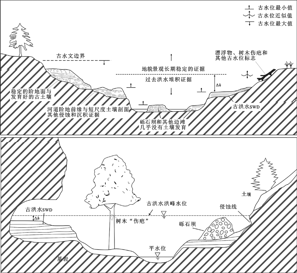
图1 古洪水地貌证据和水位标志关系示意图(据文献[36,37])
Fig.1 A schematic diagram showing the correlation between the geomorphic evidences of palaeoflood and palaeostage indictors. Adapted from [36-37].

图2 高山峡谷古洪水沉积、古泥石流扇和古滑坡堆积体地貌位置示意图
Fig.2 Schematic diagram showing the geomorphic positions of palaeoflood deposits, debris flow fans and landslide deposits in a mountain canyon valley
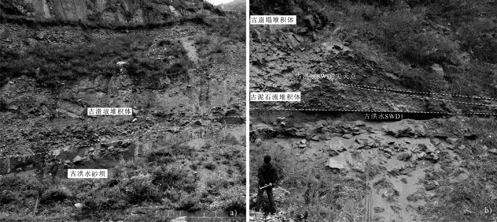
图3 岷江上游河谷古洪水砂坝沉积和古洪水滞流沉积物被古崩塌、滑坡、泥石流堆积体掩埋
Fig.3 Examples of palaeoflood sand bars and SWD covered by debris flow and landslide deposits in the upper Minjiang River valley

图4 古洪水地貌证据的二维模型模拟结果(据文献[46])
Fig.4 Results of sedimention and river hydraulic-2D(SRH-2D) modeling of palaeoflood deposits and hydrodynamic condition. Adapted from [46].

图5 岷江上游叠溪段滑坡坝与近坝处河道地貌景观
Fig.5 Geomorphic landscape of ancient landslide-dammed lake in the Diexi reach of the upper Minjiang River
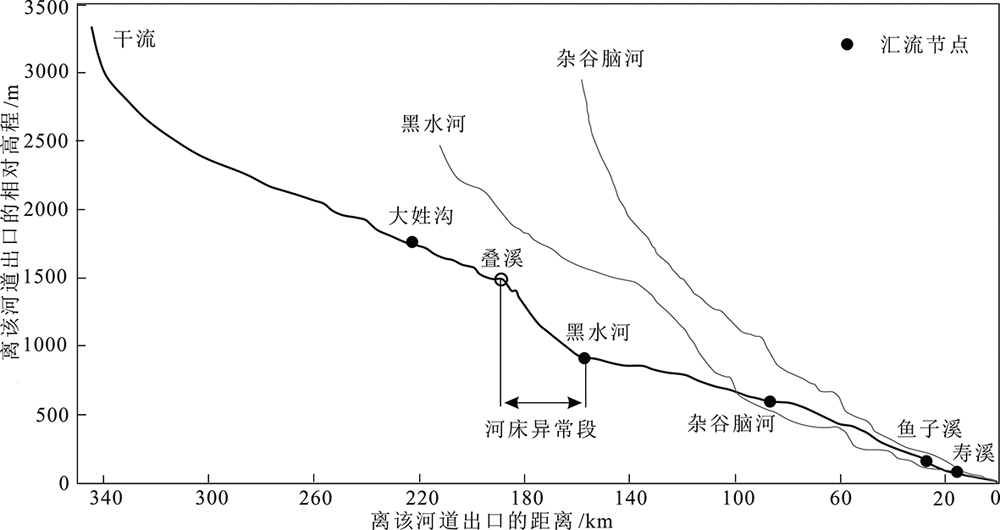
图6 岷江上游河道纵剖面变化(据文献[51])
Fig.6 The longitudinal profile of the upper Minjiang River. Adapted from [51].

图7 全球不同地质载体的古洪水档案记录(据文献[7,57])
Fig.7 Palaeoflood records of different geological carriers around the world. Adapted from [7,57].

图8 洪水涡流地貌特征以及大型边滩坝沉积与水位关系图(据文献[55,60]修改)
Fig.8 Geomorphic feature of eddy bar and the spatial relationships between large scale bar and PSIs during the catastrophic palaeofloods. Modified after [55,60].

图9 溃决洪水沉积物(outburst floods deposits,OFD)砂砾石坝地层沉积特征 a—岷江上游砂砾石坝OFD;b,c—易贡砾石坝OFD;d—雅江砂坝OFD。
Fig.9 Sedimentary characteristics of outburst flood deposits (OFD) in the upper Minjiang and Yarlung-Tsangpo River valley
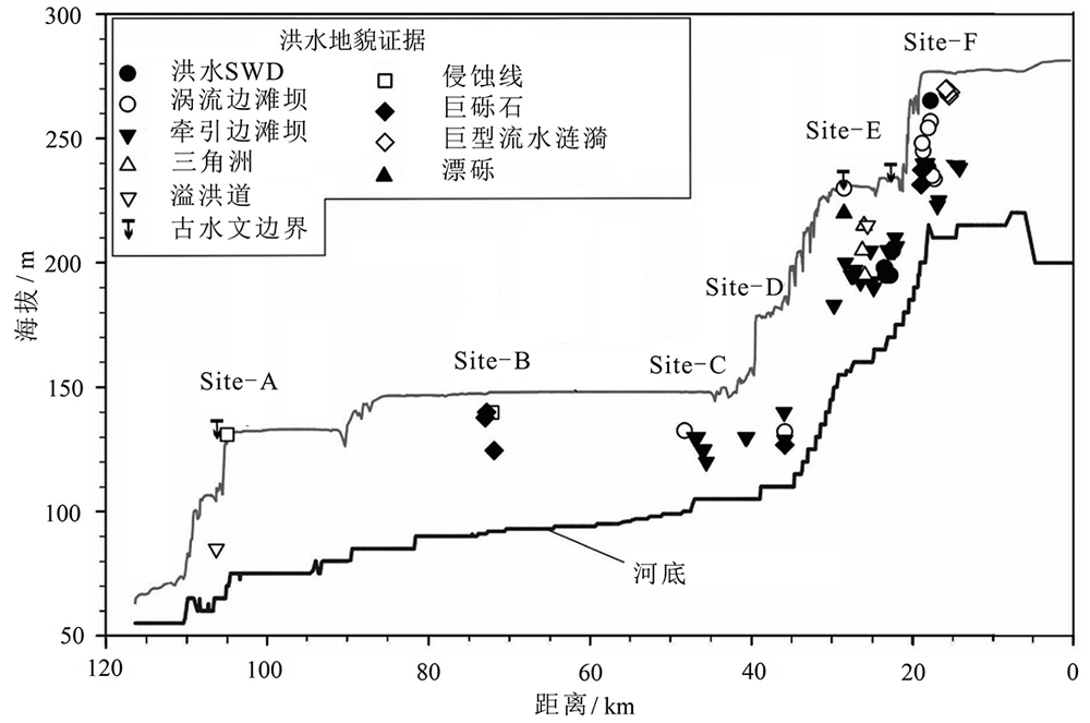
图10 基于不同类型洪水地貌证据的灾难性古洪水重建(据文献[61])
Fig.10 Catastrophic palaeoflood reconstruction based on different geomorphic evidences. Adapted from [61].
| [1] |
BAKER V R. Paleoflood hydrology and extraordinary flood events[J]. Journal of Hydrology, 1987,96:79-99.
DOI URL |
| [2] |
STEINGER J R, BAKER V R. Surface water hydrology: historical and palaeoflood information[J]. Reviews of Geophysics, 1987,25(2):119-124.
DOI URL |
| [3] | COSTA J E. A history of paleoflood hydrology in the United States, 1800-1970[M]. Washington DC: American Geophysical Union, 1987: 49-53. |
| [4] |
BRETZ J H, SMITH H T U, SMITH H T U . Channeled scabland of Washington: new data and interpretations[J]. Geological Society of America Bulletin, 1956,67(8):957-1049.
DOI URL |
| [5] |
KOCHEL R C, BAKER V R. Paleoflood hydrology[J]. Science, 1982,215(4531):353-361.
DOI URL |
| [6] | BAKER V R, KOCHEL R C, PATTON P C. Flood geomorphology[M]. New York: John Wiley & Sons, Inc., 1987. |
| [7] | BAKER V R. Global late Quaternary fluvial paleohydrology: with special emphasis paleofloods and megafloods[M]// SHRODER J, WOHL E E. Treatise on geomorphology, Volume 9. San Diego: Academic Press, 2013:511-527. |
| [8] | BENITO G, DIEZ-HERRERO A. Palaeoflood hydrology: reconstructing rare events and extreme flood discharges[M]//PARON P, BALDASSARRE G D. Hydro-meteorological hazards, risks, and disasters. Amsterdam: Elsevier, 2015: 65-104. |
| [9] |
BAKER V R. Palaeoflood hydrology in a global context[J]. Catena, 2006,66(1/2):161-168.
DOI URL |
| [10] |
BAKER V R. Paleoflood hydrology: origin, progress, prospects[J]. Geomorphology, 2008,101(1/2):1-13.
DOI URL |
| [11] | Past Global Changes (PAGES). Floods Working Group [EB/OL]. [2020-12-28]. http://pastglobalchanges.org/science/wg/floods/intro |
| [12] | 徐润滋. 关于用地貌学方法估算河流极限洪水问题的初步探讨[J]. 水文, 1982,2(5):37-40, 31. |
| [13] | 詹道江, 谢悦波. 古洪水研究[M]. 北京: 中国水利水电出版社, 2001. |
| [14] | 夏正楷, 王赞红, 赵青春. 我国中原地区3500 a BP前后的异常洪水事件及其气候背景[J]. 中国科学:D辑, 2003,33(9):881-888. |
| [15] | 葛兆帅, 杨达源, 李徐生, 等. 晚更新世晚期以来的长江上游古洪水记录[J]. 第四纪研究, 2004,24(5):555-560. |
| [16] | 张斌, 李徐生, 韩志勇, 等. 古洪水重建研究综述[J]. 水利水运工程学报, 2013(3):92-100. |
| [17] | 朱诚, 郑朝贵, 马春梅, 等. 长江三峡库区中坝遗址地层古洪水沉积判别研究[J]. 科学通报, 2005,50(20):2240-2250. |
| [18] | 张玉芬, 李长安, 陈亮, 等. 基于磁组构特征的江汉平原全新世古洪水事件[J]. 地球科学:中国地质大学学报, 2009,34(6):985-992. |
| [19] | 黄春长, 李晓刚, 庞奖励, 等. 黄河永和关段全新世古洪水研究[J]. 地理学报, 2012,67(11):1493-1504. |
| [20] | 邬龙, 谢悦波, 聂秋月, 等. 雅鲁藏布江加查峡谷河段古洪水沉积特征[J]. 河海大学学报(自然科学版), 2010,38(2):134-138. |
| [21] |
YANG D, YU B, XIE Y, et al. Sedimentary records of large Holocene floods from the middle reaches of the Yellow River, China[J]. Geomorphology, 2000,33(1/2):73-88.
DOI URL |
| [22] |
LI X G, HUANG C C, PANG J L, et al. Sedimentary and hydrological studies of the Holocene palaeofloods in the Shanxi-Shaanxi Gorge of the middle Yellow River, China[J]. International Journal of Earth Science, 2015,104(1):277-288.
DOI URL |
| [23] |
GUO Y Q, HUANG C C, ZHOU Y L, et al. Extraordinary flood events and the response to monsoonal climatic change during the last 3000 years along the middle Yangtze River valley, China[J]. Palaeogeography, Palaeoclimatology, Palaeoecology, 2016,462:70-84.
DOI URL |
| [24] |
LIU T, HUANG C C, PANG J L, et al. Extraordinary hydro-climatic events during 1800-1600 yr BP in the Jin-Shaan Gorges along the middle Yellow River, China[J]. Palaeogeography, Palaeoclimatology, Palaeoecology, 2014,410:143-152.
DOI URL |
| [25] | 魏海燕, 黄春长, 庞奖励, 等. 黄河中游晋陕峡谷段全新世晚期洪水滞流沉积研究[J]. 地质论评, 2010,56(5):745-752. |
| [26] | 朱向锋, 黄春长, 庞奖励, 等. 渭河天水峡谷全新世特大洪水水文学研究[J]. 地理科学进展, 2010,29(7):840-846. |
| [27] |
李晓刚, 黄春长, 庞奖励, 等. 黄河壶口段全新世古洪水事件及其水文学研究[J]. 地理学报, 2010,65(11):1371-1380.
DOI |
| [28] | 赵明, 黄春长, 庞奖励, 等. 北洛河中游白水段峡谷全新世特大洪水水文学研究[J]. 自然灾害学报, 2011,20(5):155-161. |
| [29] | 王恒松, 黄春长, 周亚利, 等. 关中西部千河流域全新世古洪水事件光释光测年研究[J]. 中国科学: 地球科学, 2012,42(3):390-401. |
| [30] |
刘涛, 黄春长, 庞奖励, 等. 汉江上游郧县五峰段史前大洪水水文学恢复研究[J]. 地理学报, 2013,68(11):1568-1577.
DOI |
| [31] |
胡贵明, 黄春长, 周亚利, 等. 伊河龙门峡段全新世古洪水和历史洪水水文学重建[J]. 地理学报, 2015,70(7):1165-1176.
DOI |
| [32] | 陈莹璐, 黄春长, 张玉柱, 等. 汝河全新世古洪水沉积学与光释光测年研究[J]. 地质学报, 2017,91(10):2351-2367. |
| [33] | 陈莹璐, 黄春长, 张玉柱, 等. 黄河源区玛曲段末次冰消期古洪水事件及其光释光测年研究[J]. 冰川冻土, 2017,39(3):549-562. |
| [34] | BENITO G, O’CONNOR J E. Quantitative paleoflood hydrology[M]//SHRODER J, WOHL E. Treatise on geomorphology, Volume 9. San Diego: Academic Press, 2013: 459-474. |
| [35] | HERGET J. Reconstruction of Pleistocene ice-dammed lake outburst floods in the Altai Mountains, Siberia[J]. Special Paper of the Geological Society of America, 2005,386:1-118. |
| [36] | BAKER V R, COSTA J E. Flood power[M]//MAYER L, NASH M L. Catastrophic flooding. Boston: Allen and Unwin, 1987: 1-21. |
| [37] | JARRETT R D, ENGLAND JR J F. Reliability of paleostage indicators for paleoflood studies[M]//HOUSE P K, WEBB R H, BAKER V R, et al. Ancient floods,modern hazards: principles and applications of paleoflood hydrology, Volume 5. Washington DC: American Geophysical Union, 2002: 91-109. |
| [38] |
COSTA J E, SCHUSTER R L. The formation and failure of natural dams[J]. Geological Society of America Bulletin 1988,100:1054-1068.
DOI URL |
| [39] | PENG M, ZHANG L M. Breaching parameters of landslide dams[J]. Landslide, 2011,9:13-31. |
| [40] | O’CONNOR J E. Hydrology, hydraulics, and geomorphology of the Bonneville Flood[M]. Boulder: Geological Society of America, 1993: 1-84. |
| [41] | 朱程, 谢悦波, 成晨光. 高山峡谷大比降河段古洪水沉积物特征研究[J]. 人民长江, 2016,47(4):23-26. |
| [42] |
BENITO G, SÁNCHEZ-MOYA Y, SÁNCHEZ-MOYA Y . Sedimentology of high-stage flood deposits of the Tagus River,central Spain[J]. Sedimentary Geology, 2003,157(1/2):107-132.
DOI URL |
| [43] |
JARRETT R D, TOMLINSON E M. Regional interdisciplinary paleoflood approach to assess extreme flood potential[J]. Water Resources Research, 2000,36(10):2957-2984.
DOI URL |
| [44] |
GREENBAUM N, SCHWARTZ U, BENITO G, et al. Paleohydrology of extraordinary floods along the Swakop River at the margin of the Namib Desert and their paleoclimate implications[J]. Quaternary Science Reviews, 2014,103:153-169.
DOI URL |
| [45] |
GUO Y Q, HUANG C C, PANG J L, et al. Reconstruction palaeoflood hydrology using slackwater flow depth method in the Yanhe River valley, middle Yellow River basin, China[J]. Journal of Hydrology, 2017,544:156-171.
DOI URL |
| [46] |
LIU T, GREENBAUM N, BAKER V R, et al. Paleoflood hydrology on the lower Green River, upper Colorado River Basin, USA: an example of a naturalist approach to flood-risk analysis[J]. Journal of Hydrology, 2020,580:124337
DOI URL |
| [47] | 柴贺军, 刘汉超, 张倬元. 大型崩滑堵江事件及其环境效应研究综述[J]. 地质科技情报, 2000,19(2):87-90. |
| [48] | 徐则民, 刘文连, 黄润秋. 滑坡堵江的地貌效应[J]. 第四纪研究, 2013,33(3):490-500. |
| [49] | 王一舟, 张会平, 郑德文, 等. 非均衡河道高程剖面及其蕴含的构造活动信息[J]. 第四纪研究, 2018,38(1):220-231. |
| [50] | 周丽琴, 刘维明, 赖忠平, 等. 河流堰塞的地貌响应[J]. 第四纪研究, 2019,39(2):366-380. |
| [51] | 曾超, 赵景峰, 李旭娇. GIS支持下岷江上游水文特征空间分析[J]. 水土保持研究, 2011,18(3):5-9, 14. |
| [52] |
JOHNSTONE E, MACKLIN M G, LEWIN J. The development and application of a database of radiocarbon-dated Holocene fluvial deposits in Great Britain[J]. Catena, 2006,66(1/2):14-23.
DOI URL |
| [53] |
KALE V S, SINGHVI A K, MISHRA P K, et al. Sedimentary records and luminescence chronology of Late Holocene palaeofloods in the Luni River, Thar Desert, Northwest India[J]. Catena, 2000,40(4):337-358.
DOI URL |
| [54] |
MEDIALDEA A, THOMSEN K J, MURRAY A S, et al. Reliability of equivalent-dose determination and age-models in the OSL dating of historical and modern palaeoflood sediments[J]. Quaternary Geochronology, 2014,22:11-24.
DOI URL |
| [55] |
BALBAS A M, BARTH A M, CLARK P U, et al. 10Be dating of late Pleistocene megafloods and Cordilleran Ice Sheet retreat in the northwestern United States[J]. Geology, 2017,45(7):583-586.
DOI URL |
| [56] |
GUO Y Q, HUANG C C, ZHOU Y L, et al. Sedimentary record and luminescence chronology of palaeoflood events along the upper Hanjiang River valley, middle Yangtze River basin, China.[J]. Journal of Asian Earth Sciences, 2018,156:96-110.
DOI URL |
| [57] | WILHELM B, BALLESTEROS CÁNOVAS J A, MACDONALD N, et al. Interpreting historical, botanical, and geological evidence to aid preparations for future floods[J]. Wiley Interdisciplinary Reviews: Water, 2019,6(1):e1318. |
| [58] | O’CONNOR J E, COSTA J E. The World’s largest floods, past and present: their causes and magnitudes[M]. Washington DC: US Geological Survey, 2004. |
| [59] |
BAKER V R, BENITO G, RUDOY A N. Paleohydrology of Late Pleistocene superflooding, Altay Mountains, Siberia[J]. Science, 1993,259(5093):348-350.
DOI URL |
| [60] |
CARLING P A. Freshwater megaflood sedimentation: what can we learn about generic processes?[J]. Earth-Science Reviews, 2013,125:87-113.
DOI URL |
| [61] | O’CONNOR J E, CLAGUE J J, WALDER J S, et al. Outburst floods[M]// SHRODER J, WOHL E E. Treatise on geomorphology, Volume 9. San Diego: Academic Press, 2013: 475-510. |
| [62] |
BENITO G, THORNDYCRAFT V R. Catastrophic glacial-lake outburst flooding of the Patagonian Ice Sheet[J]. Earth-Science Reviews, 2020,200:102996.
DOI URL |
| [63] | BURR D M, CARLING P A, BAKER V R. Megaflooding on Earth and Mars[M]. Cambridge: Cambridge University Press, 2009. |
| [64] |
SMITH G. Missoula flood dynamics and magnitudes inferred from sedimentology of slack-water deposits on the Columbia Plateau, Washington[J]. Geological Society of America Bulletin, 1993,105:77-100.
DOI URL |
| [65] | 李海龙, 张岳桥, 乔彦松, 等. 青藏高原东缘大渡河中游深切河谷沉积物及其地震地质意义[J]. 地质通报, 2015,34(1):104-112. |
| [66] |
WOHL E E. Bedrock benches and boulder bars: floods in the Burdekin Gorge of Australia[J]. Geological Society of America Bulletin, 1992,104(6):770-778.
DOI URL |
| [67] |
GREENBAUM N, SCHWARTZ U, CARLING P, et al. Frequency of boulders transport during large floods in hyperarid areas using paleoflood analysis: an example from the Negev Desert, Israel[J]. Earth-Science Reviews, 2020,202:103086.
DOI URL |
| [68] | 柴贺军, 刘汉超, 张倬元. 中国堵江滑坡发育分布特征[J]. 山地学报, 2000,18(增刊):51-54. |
| [69] | 伍超, 冉洪兴, 郑永红, 等. 雅砻江唐古栋垮山堵江溃决洪水过程研究[J]. 水动力学研究与进展:A辑, 1996,11(6):646-652. |
| [70] | 冷伦. 雅砻江垮山堵江及溃泄洪水[J]. 水文, 2000,20(3):46-50. |
| [71] | 崔之久, 张梅, 崔鹏, 等. 初论堰塞湖溃坝沉积相特征[J]. 山地学报, 2015,33(2):129-140. |
| [72] | 陈剑, 崔之久. 金沙江上游雪隆囊古滑坡堰塞湖溃坝堆积体的发现及其环境与灾害意义[J]. 沉积学报, 2015,33(2):275-284. |
| [73] |
LIU W, CARLING P A, HU K, et al. Outburst floods in China: a review[J]. Earth-Science Reviews, 2019,197:102895.
DOI URL |
| [74] |
MA JX, CHEN J, CUI ZJ, et al. Sedimentary evidence of outburst deposits induced by the Diexi paleolandslide-dammed lake of the upper Minjiang River in China[J]. Quaternary International, 2018,464:460-481.
DOI URL |
| [75] |
XU H, CHEN J, CUI Z J, et al. Sedimentary facies and depositional processes of the Diexi Ancient Dammed Lake, Upper Minjiang River, China[J]. Sedimentary Geology, 2020,398:105583
DOI URL |
| [76] | COSTA J E, O’CONNOR J E. Geomorphically effective floods[M]//COSTA J E, MILLER A J, POTTER K W, et al. Natural and anthropogenic influences in fluvial geomorphology. Washington DC: American Geophysical Union, 1995: 89-104. |
| [77] |
KALE V S, HIRE P S. Effectiveness of monsoon floods on the Tapi River, India: role of channel geometry and hydrologic regime[J]. Geomorphology, 2004,57:275-291.
DOI URL |
| [78] |
DEAN D J, SCHMIDT J C. The geomorphic effectiveness of a large flood on the Rio Grande in the Big Bend region: insights on geomorphic controls and post-flood geomorphic response[J]. Geomorphology, 2013,201:183-198.
DOI URL |
| [79] | WOHL E E. Geomorphic effects of floods[M]//WOHL E E. Inland flood hazards: human, riparian, and aquatic communities. Cambridge: Cambridge University Press, 2011: 167-193. |
| [80] |
TURZEWSKI M D, HUNTINGTON K W, LEVEQUE R J. The geomorphic impact of outburst floods: integrating observations and numerical simulations of the 2000 Yigong Flood, eastern Himalaya[J]. Journal of Geophysical Research: Earth Surface, 2019,124(5):1056-1079.
DOI URL |
| [81] |
BAKER V R. The spokane flood controversy and the martian outflow channels[J]. Science, 1978,202:1249-1256.
DOI URL |
| [82] |
BAKER V R, STROM R G, GULICK V C, et al. Ancient oceans, ice sheets and the hydrological cycle on Mars[J]. Nature, 1991,352:589-594.
DOI URL |
| [83] |
BAKER V R. Water and the Martian landscape[J]. Nature, 2001,412:228-236.
DOI URL |
| [84] |
BAKER V R, HAMILTON C W, BURR D M, et al. Fluvial geomorphology on Earth-like planetary surfaces: a review[J]. Geomorphology, 2015,245:149-182.
DOI URL |
| [85] |
KIM J R, SCHUMANN G, NEAL J C, et al. Megaflood analysis through channel networks of the Athabasca Valles, Mars based on multi-resolution stereo DTMs and 2D hydrodynamicmodeling[J]. Planetary and Space Science, 2014,99:55-69.
DOI URL |
| [86] |
KOMATSU G, ACHILLE G A, POPA C, et al. Paleolakes, paleofloods, and depressions in Aurorae and Ophir Plana, Mars: connectivity of surface and subsurface hydrological systems[J]. Icarus, 2009,201:474-491.
DOI URL |
| [87] |
RODRIGUEZ J A P, BAKER V R, LIU T, et al. The 1997 Mars Pathfnder spacecraft landing site: spillover deposits from an Early Mars inland sea[J]. Scientific Reports, 2019. DOI: 10.1038/s41598-019-39632-1.
DOI |
| [88] |
MORGAN G A, CAMPBELL B A, CARTER L M, et al. 3D reconstruction of the source and scale of buried young flood channels on Mars[J]. Science, 2013,340(6132):607-610.
DOI URL |
| [89] | 王铮. 火星典型地貌特征知识的描述分类与识别[D]. 武汉:武汉大学, 2009. |
| [90] | 赵健楠, 肖龙. 火星古湖泊研究的现状、问题与展望[J]. 地球科学, 2016,41(9):1572-1582. |
| [1] | 孙炜毅, 刘健, 严蜜, 宁亮. 全新世亚洲季风百年-千年尺度变化的模拟研究进展[J]. 地学前缘, 2022, 29(5): 342-354. |
| [2] | 田芝平, 张冉, 姜大膀. 全新世中期中国气候和东亚季风:PMIP4模式结果[J]. 地学前缘, 2022, 29(5): 355-371. |
| [3] | 燕青. 亚洲高山区全新世中期气候及其影响下的冰川模拟[J]. 地学前缘, 2022, 29(5): 372-381. |
| [4] | 吴家望, 姚胜男, Amalia FILIPPIDI, 刘志飞, Gert J. DE LANGE. 全新世东地中海的陆源碎屑输入及其水文气候变化:海盆尺度地球化学分析[J]. 地学前缘, 2022, 29(4): 156-167. |
| [5] | 丁大林,李广雪,徐继尚,丁咚,李倩,王丽艳,王昊寅,张洋. 全新世亚洲季风演变[J]. 地学前缘, 2017, 24(4): 114-123. |
| [6] | 公王斌, 胡健民, 李振宏, 吴素娟, 刘洋, 阎纪元. 河套盆地西缘山前低台地沉积特征对“吉兰泰—河套”古湖消退过程及其控制因素的指示意义[J]. 地学前缘, 2013, 20(4): 190-198. |
| [7] | 朱诚, 马春梅, 李兰, 孙智彬, 郑朝贵, 白九江, 朱光耀, 黄润. 长江三峡库区全新世环境考古研究进展[J]. 地学前缘, 2010, 17(3): 222-232. |
| [8] | 陈发虎 陈建徽 黄伟. 中纬度亚洲现代间冰期气候变化的“西风模式”讨论[J]. 地学前缘, 2009, 16(6): 23-32. |
| [9] | 史辰羲 莫多闻 毛龙江 刘辉. 京山屈家岭地区全新世中晚期环境变化及其对人类活动的影响[J]. 地学前缘, 2009, 16(6): 120-128. |
| [10] | 余克服 陈特固. 南海北部晚全新世高海平面及其波动的海滩沉积证据[J]. 地学前缘, 2009, 16(6): 138-145. |
| [11] | 李世杰 Bernd Wünnemann 夏威岚 于守兵 沈德福 姜永见. 青藏高原兹格塘错沉积记录的全新世水位变化事件及其原因初步研究[J]. 地学前缘, 2009, 16(6): 162-167. |
| [12] | 刘再华 孙海龙 张金流. 山西娘子关泉钙华记录的MIS12/11以来的气候和植被历史[J]. 地学前缘, 2009, 16(5): 99-. |
| [13] | 方晶 武亚芳 李瑞武 周江 康玲玲 柴锐 马楠. 辽宁沿海早、中期全新世海进中的一次海退事件探讨[J]. 地学前缘, 2009, 16(2): 396-403. |
| 阅读次数 | ||||||
|
全文 |
|
|||||
|
摘要 |
|
|||||